
CORZ Indonesia | Research & Studies
When Evidence Moves with the Ocean, Search Operations Need to Understand the Ocean Too
Check out some other model outputs on YouTube @CORZIndonesia
A marine accident begins at a location.
That location does not necessarily define where all subsequent evidence will remain.
Debris may float.
Lightweight material may drift.
Objects within the surface layer or water column may be transported.
And while search teams work, the ocean continues to move.
The key question is therefore not only:
“Where did the aircraft enter the sea?”
It also becomes:
Where were the currents moving afterward?
How rapidly could floating material be transported?
How did the current field change during the following hours?
Could newly discovered evidence have drifted from another location?
And how can predictive ocean information support interpretation of the search area?
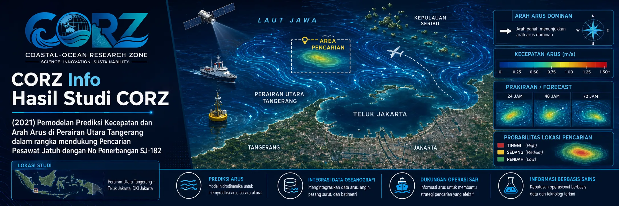
In 2021, CORZ Indonesia conducted Research & Studies involving:
Predictive Current-Speed and Direction Modelling to Support the Search for Sriwijaya Air Flight SJ-182 in the Waters North of Jakarta and Surrounding Areas.
The study applied numerical ocean modelling to a highly time-sensitive purpose:
MARITIME SEARCH & RECOVERY SUPPORT.
9 January 2021: Sriwijaya Air SJ-182 Crashes into the Java Sea
On 9 January 2021, Sriwijaya Air Flight SJ-182, a Boeing 737-500 operating from Jakarta to Pontianak, crashed into the Java Sea only minutes after departure.
Reuters reported 62 people aboard, including crew, and rescue teams were rapidly deployed after suspected debris was located near Laki Island.
Reuters — Indonesian plane crashes after take-off with 62 aboard
The crash location was subsequently established in the Thousand Islands waters, and search teams began recovering aircraft debris.
At that point, oceanography became directly relevant to the search:
Where could the moving water transport the evidence?
CORZ Research: Predict the Current Rather Than Guess the Drift
CORZ modelled the speed and direction of marine currents through time.
The result is not merely a static current map.
It is a sequence:
CURRENT FIELD t₀
→
CURRENT FIELD t₁
→
CURRENT FIELD t₂
→
CURRENT FIELD tₙ
Each vector contains:
DIRECTION × VELOCITY × LOCATION × TIME.
Conceptually:
BATHYMETRY & OCEANOGRAPHIC INFORMATION
↓
BOUNDARY / TIDAL / METEOROLOGICAL FORCING
↓
HYDRODYNAMIC MODEL
↓
CURRENT SPEED & DIRECTION
↓
PREDICTED CURRENT FIELD
↓
SEARCH-AREA INTERPRETATION SUPPORT
This makes the ocean a dynamically evolving search environment rather than a fixed map.
Operational Authorities Also Used Current Forecasts during the SJ-182 Search
The operational importance of current information was demonstrated directly during the accident response.
On 10 January 2021, Indonesia's BMKG issued dedicated marine forecasts to support SJ-182 search-and-rescue operations.
Alongside weather and wave predictions, BMKG specifically provided:
SURFACE CURRENT DIRECTION AND SPEED.
For 10–12 January, the agency forecast surface currents oriented from northeast toward southeast at approximately 5–20 cm/s.
BMKG — Marine forecasts supporting the SJ-182 search operation
BMKG also deployed weather-monitoring equipment and its Ocean Forecast System to support the SAR command post.
These official forecasts are not CORZ results and are not presented here as numerical validation of the CORZ model.
Their importance is contextual:
current prediction was itself recognised as useful operational information during the real SJ-182 response.
From Crash Location to Drift
For material capable of being transported by water:
POSITION AT t₀ ≠ NECESSARILY POSITION AT t₁.
The process becomes:
INITIAL LOCATION
↓
CURRENT + WIND + TIME
↓
DRIFT
↓
POTENTIAL NEW LOCATION.
A search team can also ask the inverse question:
EVIDENCE FOUND HERE
↓
WHAT WERE THE PREVIOUS CURRENTS?
↓
WHERE COULD IT HAVE COME FROM?
Predictive hydrodynamics provides the physical framework for both questions.
Distance Is Not the Same as Drift
An object does not simply expand outward from an accident location in a perfect circle.
Its movement depends on:
CURRENT DIRECTION
CURRENT SPEED
WIND
OBJECT CHARACTERISTICS
TIME
Therefore:
STRAIGHT-LINE DISTANCE ≠ TRANSPORT PATH.
A hydrodynamic model replaces a simple radius with a physically based picture of moving water.
Why Are the Waters North of Tangerang Relevant?
The primary crash site was within the Thousand Islands waters near Laki and Lancang Islands.
However, the wider search context also involved the Tangerang coast.
On 10 January, ANTARA reported that fishermen from Tanjung Kait, Tangerang, joined efforts to search for aircraft debris around the Laki Island area.
ANTARA — Tangerang fishermen assist the SJ-182 debris search
Later in January, detikNews reported that suspected victim remains were discovered on the Pakuhaji coast in Tangerang, with police at the time noting the proximity of the coastline to the Lancang Island area.
detikNews — Suspected SJ-182 victim material found on the Tangerang coast
These observations do not demonstrate that CORZ predicted those findings.
They show why a hydrodynamic domain encompassing the wider Tangerang–Jakarta–Thousand Islands marine system can be relevant to regional drift analysis.
Currents Were a Real Operational Challenge
Ocean currents were not merely theoretical during the recovery operation.
On the ninth day, ANTARA reported that divers were being challenged by strong underwater currents as well as poor visibility.
Two days later, strong current and adverse weather were also cited when a Basarnas vessel collided with another vessel participating in the operation.
This demonstrates two distinct roles for current information:
DRIFT INTERPRETATION
and:
OPERATIONAL SAFETY.
What Can Predictive Current Modelling Support?
For an aircraft accident at sea, hydrodynamic information can help assess the movement of:
- floating aircraft fragments
• personal belongings
• emergency equipment
• oil or fuel sheen
• other buoyant material
• selected material within the water column
It can help answer:
Where might material be transported?
How could its pathway change over several hours?
How can a new finding be interpreted against the predicted current field?
Where might additional surface observations be useful?
But hydrodynamics should not be confused with direct underwater detection.
Hydrodynamics Supports the Search. Sonar Finds the Seabed Target.
A:
HYDRODYNAMIC MODEL
provides information about:
MOVING WATER.
Direct detection of seabed wreckage requires other technologies, including:
sonar • multibeam echosounding • pinger detection • underwater vehicles • divers and specialised survey systems.
The real SJ-182 operation involved thousands of personnel, dozens of vessels, aircraft, underwater equipment, and divers.
This was therefore a:
MULTI-SENSOR, MULTI-DATA, MULTI-AGENCY OPERATION.
Search Areas Expand—and Then Contract as Evidence Accumulates
On 15 January, the aerial search area was expanded into three sectors totalling approximately 222 square nautical miles.
Later, as fewer underwater objects remained to be investigated and more information became available, authorities narrowed parts of the search area.
The workflow is familiar to operational modelling:
INITIAL AREA
↓
OBSERVATION
↓
NEW EVIDENCE
↓
UPDATED SEARCH HYPOTHESIS
↓
REFINED SEARCH AREA
Current predictions can contribute one layer of evidence to this iterative process.
The Search Environment Was Continuously Changing
Search conditions did not remain constant.
Reuters reported that on 13 January, diving operations for the cockpit recorder were temporarily suspended after bad weather generated waves of up to approximately 2.5 metres.
BMKG likewise warned that high wind and waves could interfere with the search-and-recovery effort.
The operational environment therefore consisted of:
CURRENT + WIND + WAVES + WEATHER + VISIBILITY.
A current model provides one essential part of that changing marine picture.
From Current Prediction to Search Intelligence
The greatest value emerges when several forms of information are combined:
CRASH LOCATION
CURRENT PREDICTION
WIND
DEBRIS OBSERVATIONS
BATHYMETRY
SONAR
DIVER / UNDERWATER-VEHICLE INFORMATION
↓
SEARCH INTELLIGENCE.
The objective is not to make one model responsible for the whole search.
It is to:
reduce uncertainty with better physical information.
Model → Observe → Update → Search
Rapid-response modelling works best as an iterative process.
MODEL
↓
OBSERVE
↓
COMPARE
↓
UPDATE
↓
SEARCH AGAIN.
If evidence appears somewhere unexpected, the interpretation is updated.
If weather changes, the forcing changes.
If currents change, trajectories change.
This is the transition from a static simulation to:
OPERATIONAL OCEAN MODELLING.
From Coastal Modelling to Emergency Response
The 2021 SJ-182 study demonstrates that CORZ hydrodynamic expertise can extend beyond conventional engineering and environmental applications.
The same ocean physics can support:
- Maritime Search & Recovery
• Aircraft-Accident Search Support
• Drift Prediction
• Debris Tracking
• Oil/Fuel-Slick Interpretation
• Emergency Marine Operations
• Search-Area Analysis
• Marine-Incident Reconstruction
Because every one of these applications begins with the same physical reality:
THE OCEAN MOVES.
Predict the Current. Follow the Evidence. Reduce the Search Uncertainty.
Evidence in a marine accident does not always remain where the accident occurred.
The moving ocean can transport it.
Understanding current speed and direction therefore helps connect:
where an accident occurred
with:
where evidence may later be observed.
The 2021 SJ-182 study reflects the CORZ Indonesia Research & Studies approach:
Start from the Incident Location.
Predict the Currents.
Follow the Time Evolution.
Understand the Drift.
Compare with Field Observations.
Update the Search Interpretation.
Reduce the Uncertainty.
Support Better Emergency Decisions.
Because during a marine search, the useful question is not only:
“Where did it fall?”
It is also:
“Where could the moving ocean carry the evidence next?”
CORZ Indonesia for Research & Studies
Predictive Current Modelling • Hydrodynamic Modelling • Maritime Search & Recovery Support • Drift Prediction • Debris Tracking • Marine Emergency Modelling
Coastal-Ocean Research Zone (CORZ) Indonesia provides research, modelling, analysis, and technical solutions for coastal and ocean environments.
YouTube — CORZ Indonesia
Website — CORZ Indonesia
Email: info@corz.co.id
© 2026 CORZ Indonesia. All Rights Reserved.


