
CORZ Indonesia | Research & Studies
When Every Hour Matters, Understanding Where the Ocean Is Moving Matters Too
Check out some other model outputs on YouTube @CORZIndonesia
The ocean never stops moving.
When an object, oil slick, floating material, or debris enters the marine environment, its position does not necessarily remain where it was first released or observed.
Currents move.
Tides evolve.
Wind acts on the sea surface.
And as time passes, a single last known position can develop into an increasingly uncertain search area.
During a maritime emergency, the question is therefore not only:
“Where was the target last known to be?”
It also becomes:
Where was the surrounding water moving?
How rapidly was it moving?
How did the current field evolve over the following hours?
If floating evidence was found elsewhere, where might it have originated?
And how could oceanographic prediction help interpret a rapidly evolving search area?
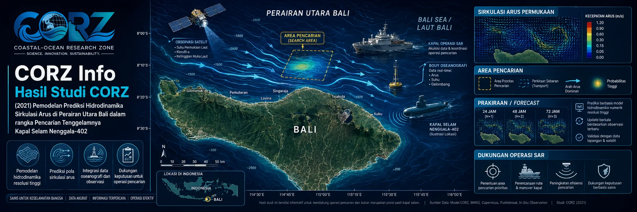
In 2021, CORZ Indonesia conducted Research & Studies involving:
Predictive Hydrodynamic Current-Circulation Modelling to Support the Search for KRI Nanggala-402 in Northern Bali Waters.
The study brought numerical ocean modelling into one of the most time-critical marine applications:
SEARCH & RESCUE SUPPORT.
21 April 2021: KRI Nanggala-402 Loses Contact North of Bali
In the early hours of 21 April 2021, KRI Nanggala-402 received clearance to dive during a torpedo-training exercise.
Communication was subsequently lost.
Indonesian Navy vessels began searching the area using active sonar, and an aerial observation later identified an oil slick near the location where the submarine had begun its dive.
detikNews — Timeline of the disappearance of KRI Nanggala-402
ANTARA reported that the submarine, carrying 53 people, had lost contact in waters north of Bali and that vessels equipped for underwater searching were deployed.
The incident rapidly became a major multinational maritime-search operation.
From an oceanographic perspective, it also posed an urgent question:
What was the water doing within the search area?
CORZ Research: Predicting a Time-Evolving Current Field
CORZ conducted predictive hydrodynamic modelling to represent current circulation across the search environment.
The key information was:
CURRENT DIRECTION
CURRENT VELOCITY
LOCATION
TIME
forming a:
SPATIAL–TEMPORAL CURRENT FIELD.
Conceptually:
OCEANOGRAPHIC DATA
+
BATHYMETRY
+
BOUNDARY / TIDAL FORCING
+
OTHER RELEVANT FORCING
↓
HYDRODYNAMIC MODEL
↓
CURRENT DIRECTION & VELOCITY
↓
TIME-EVOLVING CURRENT FIELD
↓
SEARCH-AREA INTERPRETATION SUPPORT
This is not a single static map.
It is a sequence:
t₀ → t₁ → t₂ → t₃ → tₙ.
Because the ocean at sunrise does not necessarily have the same current pattern several hours later.
A Last Known Position Is Not Always the Last Possible Position
A Last Known Position (LKP) provides the initial reference for many search operations.
For material transported by the water, however:
POSITION AT t₀
does not necessarily equal:
POSITION AT t₁.
The conceptual process becomes:
LAST KNOWN POSITION
↓
CURRENT + WIND + TIME
↓
POTENTIAL DRIFT
↓
SEARCH AREA
As time increases, uncertainty can expand.
Predictive ocean information helps provide a physical basis for understanding that expansion.
What Can Current Modelling Actually Support?
Scientific precision is particularly important in this case.
For floating or near-surface evidence such as:
oil slicks • buoyant debris • life-saving equipment • other floating objects,
surface currents can be important contributors to drift.
Currents at depth may similarly influence material suspended within the water column.
However, a submarine resting on the seabed does not drift like floating debris.
Therefore hydrodynamic modelling should be positioned correctly.
CURRENT MODELLING CAN SUPPORT:
- understanding the ocean-current environment;
- estimating potential drift of floating evidence;
- interpreting the relationship between observed debris and possible source locations;
- supporting evolution of the search-area hypothesis;
- planning surface and marine survey operations.
IT DOES NOT REPLACE:
- sonar;
- magnetometers;
- multibeam echosounders;
- side-scan sonar;
- remotely operated vehicles;
- underwater acoustic detection; or
- other specialist submarine-search systems.
In short:
Hydrodynamics helps interpret the search environment.
Underwater sensors locate the target.
From an Oil Slick to a Drift Question
One of the earliest clues in the Nanggala search was the oil slick observed near the dive area.
An oil slick can be an important observation.
But after spending time on the surface, the location where oil is observed does not necessarily correspond exactly to where it entered the water.
Conceptually:
SOURCE LOCATION
↓
SURFACE CURRENT + WIND
↓
OIL-SLICK DRIFT
↓
OBSERVED LOCATION
This changes the question from:
“Where was the oil observed?”
to:
“How could the water have moved the oil since release?”
That is precisely the type of physical context a current model can provide.
Current Vectors: Every Arrow Tells Part of the Search Story
A model current vector contains:
DIRECTION + VELOCITY.
Adding geography gives:
DIRECTION + VELOCITY + LOCATION.
Adding prediction time gives:
DIRECTION + VELOCITY + LOCATION + TIME.
For a time-critical maritime search, that final dimension is essential.
One arrow is a snapshot.
Thousands of vectors evolving through time create a dynamic picture of the search environment.
Forecast the Water—Do Not Guess the Search
There is a major difference between simply guessing where evidence might move and numerically calculating the expected movement of the surrounding water.
The modelling chain is:
DATA
↓
PHYSICAL EQUATIONS
↓
NUMERICAL SIMULATION
↓
CURRENT PREDICTION
↓
SEARCH-SUPPORT INFORMATION
Numerical predictions always carry uncertainty.
But they provide a systematic physical framework for search planning and interpretation.
Real Search Operations Combine Many Independent Clues
The Nanggala operation demonstrated why multi-source information matters.
During 23–24 April, search teams assessed evidence including oil, debris, and magnetic contacts while specialised vessels conducted underwater searches. ANTARA reported that operations remained focused in northern Bali and that a strong magnetic anomaly had become one of the search targets.
ANTARA — Search for KRI Nanggala-402 begins to identify promising targets
A modern search can therefore combine:
LAST KNOWN POSITION
OCEAN CURRENT INFORMATION
OIL SLICK / DEBRIS
MAGNETIC CONTACT
SONAR
BATHYMETRY
MULTIBEAM ECHOSOUNDER
ROV
↓
SEARCH INTELLIGENCE.
From a Large Area to Specific Search Targets
By 25 April, the search had been focused around several candidate locations in northern Bali.
Kompas reported that nine points were being examined, including locations associated with oil and strong magnetic signatures.
Kompas — Search locations for KRI Nanggala-402 in northern Bali
This illustrates the process of reducing uncertainty:
LARGE SEARCH DOMAIN
↓
NEW DATA
↓
UPDATED INTERPRETATION
↓
TARGETED SURVEY
↓
NARROWER SEARCH ZONE
Hydrodynamic prediction can contribute one physical layer within that process.
25 April 2021: The Submarine Is Located at 838 Metres
On 25 April, KRI Rigel obtained a significant underwater contact using a multibeam echosounder.
Because its ROV was limited to approximately 800 metres, the contact was subsequently investigated using an ROV from Singapore's MV Swift Rescue.
At 09:04 local time, the ROV obtained visual confirmation.
KRI Nanggala-402 was found:
at a depth of 838 metres
and approximately:
1,500 yards south of the original datum.
ANTARA reported that the wreck had separated into multiple sections and that all 53 crew members had died.
ANTARA — KRI Nanggala-402 found at a depth of 838 metres
Reuters, carried by The Jakarta Post, also reported the discovery of the submarine on the seabed following the multinational search.
The Jakarta Post / Reuters — Sunken KRI Nanggala-402 found by rescuers
CORZ Modelling Should Not Be Presented as the System That Located Nanggala
This distinction strengthens the credibility of the portfolio.
The CORZ activity was:
predictive hydrodynamic modelling relevant to understanding the search environment.
The physical wreck was located using specialised underwater-survey and detection technology, particularly multibeam echosounding and ROV visual identification.
The appropriate message is therefore:
CORZ provided hydrodynamic insight relevant to search-support analysis.
Not:
CORZ discovered the submarine.
Scientific credibility matters—especially when describing a real tragedy.
Why Is Submarine Search So Difficult?
A submarine is specifically designed to avoid detection.
An article examining the Nanggala operation noted that even in exercises, continuously tracking a submerged submarine with sonar can be extremely difficult.
Kompas — Why is a missing submarine so difficult to locate?
Northern Bali also transitions rapidly toward deep-water environments.
Search teams therefore faced a combination of:
large area • deep water • limited visibility • complex bathymetry • moving water • difficult target detection.
In such an environment:
every reliable layer of information matters.
From Current Prediction to Search Probability
Within a broader search-and-rescue drift framework:
LAST KNOWN POSITION
↓
CURRENT FORECAST
WIND
OBJECT DRIFT CHARACTERISTICS
UNCERTAINTY
↓
POSSIBLE TRAJECTORIES
↓
PROBABILITY-BASED SEARCH AREA
The concept demonstrates why ocean prediction can become operationally valuable.
But model results must always be updated against actual observations.
The strongest workflow is:
MODEL → OBSERVE → UPDATE → SEARCH.
Modelling Does Not Replace Search and Rescue
Search and rescue is inherently multidisciplinary.
A major operation may require:
NAVY • SAR TEAMS • HYDROGRAPHERS • OCEANOGRAPHERS • AIRCRAFT • SONAR • SATELLITES • ROVs • INTERNATIONAL SUPPORT
Numerical modelling is one element.
Its role is to translate the moving marine environment into usable information.
When multiple technologies are integrated:
DATA BECOMES SEARCH INTELLIGENCE.
From Ocean Modelling to Emergency Decision Support
The 2021 Northern Bali study demonstrates another application of hydrodynamic modelling beyond conventional coastal engineering.
It can support:
- Maritime Search & Rescue
• Missing-Vessel Search Analysis
• Drift Prediction
• Floating-Debris Tracking
• Oil-Slick Interpretation
• Emergency Marine Operations
• Search-Area Planning
• Marine-Incident Reconstruction
The fundamental physics remains the same:
WATER MOVES.
Understanding that movement can reduce uncertainty when time matters most.
Predict the Current. Reduce the Uncertainty.
During a maritime search, complete information is rarely available.
There may only be:
a last known position,
a timestamp,
an oil slick,
floating debris,
a magnetic anomaly,
or a sonar contact.
Science helps transform those fragmented observations into a structured physical picture.
The 2021 Northern Bali study reflects the CORZ Indonesia Research & Studies approach:
Start from the Last Known Position.
Model the Currents.
Follow the Time Evolution.
Interpret the Drift.
Combine Model and Observation.
Reduce the Search Uncertainty.
Support Better Maritime Decisions.
Because at sea, the critical question is not only:
“Where was it last known to be?”
It may also be:
“Where could the ocean have carried the evidence next?”
CORZ Indonesia for Research & Studies
Predictive Hydrodynamic Modelling • Current Circulation • Maritime Search & Rescue Support • Drift Prediction • Marine Emergency Modelling • Search-Area Analysis
Coastal-Ocean Research Zone (CORZ) Indonesia provides research, modelling, analysis, and technical solutions for coastal and ocean environments.
YouTube: https://www.youtube.com/@CORZIndonesia
Website: https://corz.co.id
Email: info@corz.co.id
© 2026 CORZ Indonesia. All Rights Reserved.


