
CORZ Indonesia | Research & Studies
Before a Tsunami Sensor Can Watch the Ocean, We Need to Understand the Ocean Where It Will Be Installed
Check out some other model outputs on YouTube @CORZIndonesia
A tsunami early-warning system may appear to begin with a sensor waiting silently on the seafloor.
In reality, the challenge begins much earlier.
What is the marine environment where the system will be deployed?
How do the currents behave?
How do velocity and direction vary through space and time?
What conditions connect the coastal zone with deep water?
And how can oceanographic information support the installation of cables and instruments that may eventually operate thousands of metres below the sea surface?
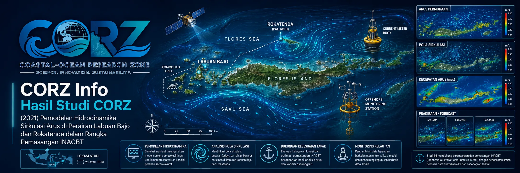
In 2021, CORZ Indonesia conducted Research & Studies involving:
- Hydrodynamic Current-Circulation Modelling to Support InaCBT Tsunami-Warning Installation in Labuan Bajo
- Hydrodynamic Current-Circulation Modelling to Support InaCBT Tsunami-Warning Installation at Rokatenda
Two marine environments.
Two deployment areas.
One larger objective:
strengthening Indonesia's ability to observe tsunami-related signals from the deep ocean.
InaCBT: Connecting the Seafloor to the Shore
InaCBT—the Indonesia Cable-Based Tsunameter— is a cable-connected tsunami-observation technology.
Sensors deployed on the seabed are linked to shore through fiber-optic cable.
In November 2021, ANTARA reported plans to install InaCBT systems at Labuan Bajo and Rokatenda by the end of the year. The deep-water sensors would detect changes in seabed water pressure and rapidly transmit data toward the land-based observation system.
ANTARA — BRIN prepares InaCBT installation in Labuan Bajo and Rokatenda, November 2021
The observation chain can be expressed as:
SEAFLOOR DISTURBANCE
↓
BOTTOM-PRESSURE CHANGE
↓
OCEAN-BOTTOM SENSOR
↓
FIBER-OPTIC CABLE
↓
LAND-BASED STATION
↓
DATA CENTRE
↓
TSUNAMI EARLY-WARNING INFORMATION.
InaCBT is therefore more than an underwater instrument.
It connects:
OCEAN → SENSOR → DATA → INFORMATION → WARNING → EVACUATION.
Where Does CORZ Hydrodynamic Modelling Fit?
The distinction between observation technology and numerical modelling is important.
InaCBT
is designed to detect pressure and seismic-related signals on the seafloor that can contribute to tsunami monitoring.
HYDRODYNAMIC CURRENT MODELLING
describes the moving marine environment within which the observation infrastructure is deployed.
The CORZ current model is therefore not an earthquake-prediction system and not a tsunami-propagation model.
Its role is within oceanographic and marine-engineering support.
Conceptually:
BATHYMETRY + OCEAN BOUNDARIES + FORCING
↓
HYDRODYNAMIC MODEL
↓
CURRENT DIRECTION & VELOCITY
↓
SPATIAL–TEMPORAL CURRENT FIELD
↓
MARINE ENVIRONMENT INFORMATION FOR DEPLOYMENT SUPPORT.
Why Do Currents Matter for Subsea Installation?
A subsea cable is not installed on a two-dimensional drawing.
It has to be deployed through moving water.
During marine installation, vessels, cables, and underwater equipment operate within an environment influenced by currents.
Current information therefore forms one element that can be considered together with:
bathymetry • seabed conditions • depth • weather • waves • vessel capability • cable properties • deployment methodology.
Hydrodynamic modelling contributes:
CURRENT ENVIRONMENT INFORMATION.
Each vector describes:
DIRECTION × VELOCITY × LOCATION × TIME.
The installation problem becomes not merely:
WHERE IS THE ROUTE?
but also:
WHAT IS THE WATER DOING AROUND IT?
Labuan Bajo — From the Coast toward the Deep Flores Sea
The first CORZ study focused on Labuan Bajo.
Its marine environment transitions from a highly complex island-fringed coastal setting toward deep waters north of Flores.
Once deployed, the Labuan Bajo InaCBT system was reported by BRIN in 2022 to include approximately 54.7 km of cable, extending to a maximum depth of about 4,100 metres.
ANTARA — BRIN confirms InaCBT deployment at Labuan Bajo and Rokatenda
The physical transition is remarkable:
COAST
↓
SHALLOW WATER
↓
ISLAND SLOPE
↓
DEEP OCEAN
↓
OCEAN-BOTTOM SENSOR.
Understanding the marine environment along such a system contributes to broader marine situational awareness for subsea deployment.
Rokatenda — Modern Observation Technology in a Region with a Tsunami History
The second study area was Rokatenda, the volcano on Palue Island in East Nusa Tenggara.
Its disaster history makes the location particularly significant.
In August 2021, BNPB highlighted the catastrophic 1928 Rokatenda eruption, which was accompanied by a tsunami and caused hundreds of fatalities.
ANTARA — BNPB recalls historical Rokatenda eruption and tsunami
The historical case demonstrates an important point:
tsunami hazards in an island-arc environment are not associated only with major tectonic earthquakes.
Volcanic processes and submarine mass movements can also matter.
This strengthens the value of direct ocean observations in a complex tectonic–volcanic region.
Rokatenda Hydrodynamic Modelling: Understanding the Operating Environment
CORZ modelled current circulation around the Rokatenda marine environment to support the installation study.
The model addresses questions such as:
How does water circulate around the area?
How do current direction and velocity vary spatially?
How does the current field evolve through time?
A time-evolving sequence:
CURRENT FIELD t₁
→
CURRENT FIELD t₂
→
CURRENT FIELD t₃
→
CURRENT FIELD tₙ
adds dynamic information that cannot be obtained from bathymetry alone.
Bathymetry answers:
HOW DEEP?
Hydrodynamics adds:
HOW DOES THE WATER MOVE?
December 2021 Demonstrated Why Tsunami Observation Matters
Only weeks after the planned InaCBT deployment was publicly reported, a major earthquake struck the Flores Sea.
On 14 December 2021, a M7.4 earthquake occurred northwest of Larantuka.
BMKG issued a tsunami warning for parts of eastern Indonesia before subsequently ending the warning after monitoring and evaluation.
ANTARA — BMKG ends tsunami warning following M7.4 Flores Sea earthquake
detikNews reported that the earthquake was strongly felt in Labuan Bajo, prompting people to leave buildings.
detikNews — M7.4 Flores Sea earthquake strongly felt in Labuan Bajo
BMKG's subsequent technical review stated that a small tsunami was detected by sea-level observations following the earthquake.
This event was not a validation of the CORZ hydrodynamic modelling study.
It provides independent real-world context demonstrating why enhanced deep-ocean tsunami observation is valuable in the Flores region.
From a 2021 Deployment Plan to an Installed Observation System
In November 2021, InaCBT installation was still publicly described as an upcoming operation.
By May 2022, BRIN reported that the systems were installed at both locations.
The final reported configurations were approximately:
LABUAN BAJO
54.7 km of cable
reaching depths up to approximately 4,100 m
ROKATENDA
14.3 km of cable
reaching depths up to approximately 1,400 m.
BRIN explained that the system sends data captured by the seabed instruments in real time through the optical cable to a land-based station and onward to the data centre.
The sequence therefore became very tangible:
RESEARCH → MODELLING → MARINE DEPLOYMENT → OCEAN OBSERVATION.
Sensors Measure. Models Provide Context.
This is one of the strongest messages of the CORZ study.
A SENSOR
provides observations at its measurement location.
A MODEL
provides a physical representation of the surrounding marine environment.
They are complementary rather than interchangeable.
OCEAN OBSERVATION
+
NUMERICAL MODELLING
↓
BETTER OCEAN UNDERSTANDING.
Within a complete tsunami-warning architecture, other components join the system:
SEISMOLOGY + BOTTOM-PRESSURE OBSERVATION + SEA-LEVEL MONITORING + TSUNAMI MODELLING + TELECOMMUNICATION + WARNING DISSEMINATION
↓
TSUNAMI RISK REDUCTION.
Hydrodynamic Modelling Does Not Predict Earthquakes
This scientific boundary matters.
The CORZ hydrodynamic model does not predict when an earthquake will occur.
Nor does current-circulation modelling alone determine whether an earthquake will generate a tsunami.
The study provides knowledge of the hydrodynamic environment associated with deployment of the InaCBT infrastructure.
Tsunami early warning depends on an integrated system involving seismic analysis, bottom-pressure observations, tide gauges, tsunami modelling, communication infrastructure, and warning dissemination.
Therefore:
HYDRODYNAMIC MODELLING ≠ EARTHQUAKE PREDICTION.
Instead:
HYDRODYNAMIC MODELLING = MARINE ENVIRONMENT KNOWLEDGE.
Where Ocean Engineering Meets Disaster-Risk Reduction
The study connects two disciplines.
OCEAN ENGINEERING
needs to understand the marine environment where underwater infrastructure must be installed and operated.
DISASTER-RISK REDUCTION
needs reliable observation systems capable of providing information rapidly when an event occurs.
They meet in a common chain:
UNDERSTAND THE SEA
↓
INSTALL THE SYSTEM
↓
OBSERVE THE DEEP OCEAN
↓
TRANSMIT THE DATA
↓
SUPPORT EARLY WARNING
↓
PROTECT COASTAL COMMUNITIES.
From Current Modelling to Ocean-Observation Infrastructure
Studies of this type can support physical understanding relevant to:
- Subsea Cable Installation Studies
• Ocean-Bottom Instrument Deployment
• Tsunami Observation Infrastructure
• Marine Survey Planning
• Offshore Installation Support
• Hydrodynamic Current Assessment
• Ocean Monitoring Systems
• Disaster-Mitigation Infrastructure
This demonstrates another role for numerical ocean modelling.
It is not used only to model the consequences of marine hazards.
It can also support development of:
THE SYSTEMS THAT OBSERVE THOSE HAZARDS.
Model the Ocean Before Installing the System That Watches It.
A tsunami sensor may eventually operate silently thousands of metres below the surface.
But placing a reliable system there requires science and engineering long before an emergency occurs.
Understand the depth.
Understand the seabed.
Understand the currents.
Deploy the cable.
Install the sensor.
Connect the deep sea to the shore.
And make sure information can move when every second matters.
The 2021 Labuan Bajo–Rokatenda study reflects the CORZ Indonesia Research & Studies approach:
Understand the Currents.
Characterise the Marine Environment.
Support the Deployment.
Connect the Deep Sea to the Shore.
Observe the Ocean.
Strengthen Early Warning.
Protect What Matters.
Because before an observation system can ask:
“Is a tsunami coming?”
engineers and researchers must first answer:
“How do we place a reliable observing system in this ocean?”
CORZ Indonesia for Research & Studies
Hydrodynamic Modelling • Current Circulation • Subsea Cable & Instrument Deployment Support • Ocean Observation Systems • Tsunami Monitoring Infrastructure • Marine Engineering Studies
Coastal-Ocean Research Zone (CORZ) Indonesia provides research, modelling, analysis, and technical solutions for coastal and ocean environments.
YouTube: https://www.youtube.com/@CORZIndonesia
Website: https://corz.co.id
Email: info@corz.co.id
© 2026 CORZ Indonesia. All Rights Reserved.


