
CORZ Indonesia | Research & Studies
Before and After Reclamation: How Does a Changing Harbour Geometry Change the Waves?
Check out some other model outputs on YouTube @CORZIndonesia
A port is not simply built on the sea.
Its construction can also change how the sea behaves within it.
Reclamation changes the water boundary. Breakwaters alter the pathways through which wave energy enters the harbour. Dredging and basin modifications change bathymetry. New quay walls and structures create new reflecting boundaries.
When harbour geometry changes, the internal wave field can change as well.
The engineering question is therefore not simply:
“How high are the incoming offshore waves?”
It becomes:
How do waves enter the harbour?
How does reclamation modify their propagation?
Do particular areas become more sheltered?
How do wave reflection and diffraction change?
How does modification of the harbour basin affect internal wave conditions?
And does the new configuration provide better conditions for port operations?
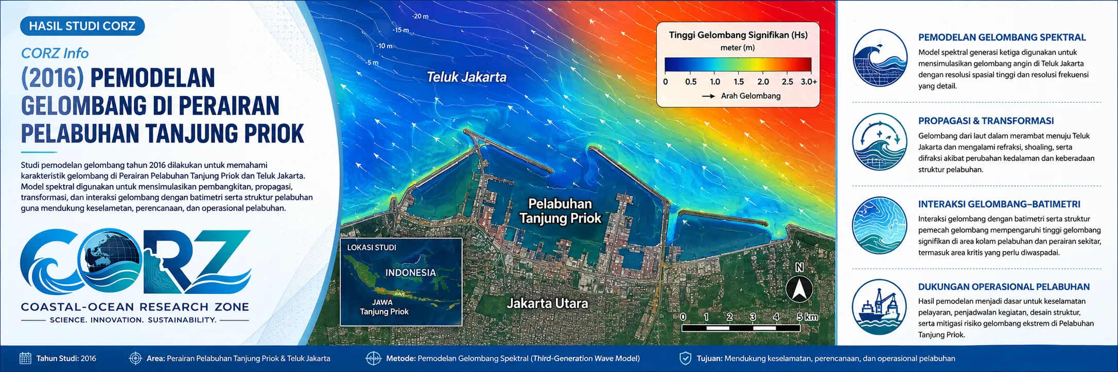
In 2016, CORZ Indonesia conducted Research & Studies involving detailed wave modelling at Tanjung Priok Port using a Boussinesq Wave approach.
The investigation compared two fundamental configurations:
- Wave-Height Modelling Before Reclamation and Harbour-Basin Modification
- Wave-Height Modelling After Reclamation and Harbour-Basin Modification
The port was therefore evaluated through a numerical before-and-after experiment.
2016: Tanjung Priok Was Undergoing Major Transformation
The timing of the study is particularly significant.
On 8 March 2016, detikFinance reported that further New Priok development was proceeding through reclamation near New Priok Container Terminal 1, with additional container and oil-and-gas terminals planned for the reclaimed area.
detikFinance — Reclamation underway at New Priok, 8 March 2016
In April 2016, detikFinance reported that approximately 25 million m³ of material would be required for the reclamation and that dredged material from the harbour basin was being used. The report also described plans to deepen harbour areas from approximately -14 m to -16 m.
detikFinance — New Priok reclamation and harbour dredging, 5 April 2016
On 13 September 2016, President Joko Widodo inaugurated New Priok Container Terminal 1. Reuters described it as the first part of a broader expansion intended to improve capacity and efficiency at Indonesia's principal international port.
Reuters — Indonesia president opens Priok port expansion, 13 September 2016
These reports were not reports about the CORZ study.
They provide the historical setting: the numerical assessment was undertaken during a period when Tanjung Priok's physical configuration and operational capacity were undergoing major change.
Why Can Reclamation Change Harbour Waves?
Consider an incoming wave approaching a harbour.
Before development, it encounters one configuration:
OPEN WATER → ENTRANCE → BREAKWATER → BASIN → BERTH
After reclamation and modification, it may encounter:
OPEN WATER → MODIFIED ENTRANCE → NEW STRUCTURES → MODIFIED BASIN → BERTH
Changes in geometry can influence:
REFRACTION
wave turning associated with changing depth;
DIFFRACTION
lateral redistribution of wave energy around openings and structures;
REFLECTION
wave energy reflected by quay walls, breakwaters, and other boundaries;
SHOALING
changes in wave height as water depth changes;
and:
WAVE INTERACTION
interactions among wave components within an enclosed or semi-enclosed basin.
The principle is straightforward:
NEW PORT GEOMETRY = NEW WAVE ENVIRONMENT.
Why Boussinesq Wave Modelling?
A Boussinesq-type wave model is particularly useful when detailed wave transformation needs to be represented within relatively shallow and geometrically complex environments.
Such modelling provides a framework for resolving processes including:
shoaling • refraction • diffraction • reflection • nonlinear wave transformation • harbour-wave propagation
For harbour studies, the ability to represent reflection and diffraction is especially important.
Incoming waves do not simply travel in straight lines through a port entrance.
Wave energy can:
enter → turn → spread → reflect → interact → produce spatially variable wave heights within the basin.
This is why detailed numerical wave modelling becomes valuable when harbour geometry is modified.
Model 1 — Before Reclamation
The first simulation represents:
BEFORE RECLAMATION & BASIN MODIFICATION.
This provides the baseline wave environment.
The model can be used to characterise:
- propagation of waves toward and into the port;
- wave-height distribution within the harbour;
- relatively sheltered areas;
- zones receiving greater wave energy;
- reflection around existing structures;
- diffraction through harbour openings; and
- wave conditions in operational areas.
The baseline is fundamental.
Without understanding the original condition, the effects of a proposed change cannot be objectively assessed.
BEFORE establishes the reference.
Model 2 — After Reclamation and Basin Modification
The second configuration represents:
AFTER RECLAMATION & BASIN MODIFICATION.
The modified geometry is then subjected to the wave simulation.
The question becomes:
What changed?
Did incoming wave pathways change?
Did new structures reduce wave penetration into particular areas?
Did new reflecting boundaries create different patterns?
Did wave-height distribution within the basin change?
Were new areas of interest created?
The proposed harbour configuration therefore becomes a numerical engineering experiment.
BEFORE vs AFTER
The greatest value emerges when both simulations are compared.
CONDITION A
Existing / Before Reclamation
versus:
CONDITION B
Modified / After Reclamation
Conceptually:
SAME EXTERNAL WAVE FORCING
+
DIFFERENT HARBOUR GEOMETRY
↓
DIFFERENT WAVE RESPONSE?
This is the central question of the study.
It enables changes associated with port geometry to be distinguished from the external wave forcing itself.
From Wave-Height Maps to Design Evaluation
A model output may initially appear to be simply a coloured map of wave heights.
Its engineering value is much greater.
A comparison between before and after conditions can identify:
WHERE THE WAVE ENVIRONMENT CHANGED.
The analysis can support evaluation of:
- areas with reduced wave height;
- locations where wave energy may increase;
- changes in wave penetration;
- changes in reflection patterns;
- relative harbour tranquillity;
- conditions around berthing areas;
- performance of structures; and
- opportunities for further design optimisation.
The transformation is:
WAVE MAP
↓
DESIGN PERFORMANCE INFORMATION.
Why Does Harbour Tranquillity Matter?
A port requires more than sufficient area and sufficient water depth.
It also requires suitable water conditions for safe and efficient operations.
Excessive wave action can affect:
vessel motions • mooring • berthing • cargo handling • tug operations • operational safety
A functional harbour therefore needs:
SPACE
DEPTH
ACCEPTABLE WAVE CONDITIONS.
This is why harbour-wave modelling is an important component of port design and expansion studies.
Tanjung Priok 2016: A Port Becoming a Different Port
In May 2016, The Jakarta Post described New Priok as a major transformation of Indonesia's largest and busiest port, intended to improve capacity and address long-standing operational constraints.
The Jakarta Post — New Priok as Jakarta's modern port landmark, 28 May 2016
After NPCT1 opened, The Jakarta Post described the terminal as only the first component of a much larger Tanjung Priok expansion programme.
The Jakarta Post — Our New Sea Gateway, 15 September 2016
This makes the before–after approach particularly relevant.
When a major harbour is physically changing, numerical modelling allows engineers and decision-makers to evaluate how the water may respond rather than waiting until construction is complete to discover the consequences operationally.
Build It Digitally Before Judging It Physically
One of the greatest strengths of numerical modelling is the ability to analyse a future configuration before—or while—it is physically being constructed.
Within the model:
EXISTING PORT
can be compared with:
PROPOSED / MODIFIED PORT.
This supports a more proactive workflow:
MODEL → COMPARE → EVALUATE → OPTIMISE → BUILD / OPERATE
instead of:
BUILD → DISCOVER A PROBLEM → MODIFY AGAIN.
From Wave Modelling to Port Decision Support
Studies of this type can support:
- Harbour Wave Agitation Studies
• Reclamation Impact Assessment
• Breakwater Design & Evaluation
• Harbour Basin Optimisation
• Port Expansion Studies
• Berthing & Mooring Assessment
• Navigation Safety Studies
• Environmental Impact Assessment
• Coastal Infrastructure Design
They can help address practical questions such as:
Is the reclamation configuration performing as intended?
How does the modified basin alter wave conditions?
Is the breakwater arrangement effective?
Which areas still experience significant wave penetration?
Could the geometry be optimised before the next construction phase?
This is where:
SIMULATION → COMPARISON → DESIGN INSIGHT → BETTER DECISIONS.
Don't Just Build the Harbour. Model How the Waves Will Respond.
Reclamation changes space.
Dredging changes depth.
Breakwaters change the pathways of wave energy.
And the sea responds to all of them.
The 2016 Tanjung Priok study represents a fundamental CORZ Indonesia Research & Studies approach:
Model the Existing Condition.
Build the Future Geometry Digitally.
Simulate the Waves.
Compare Before and After.
Evaluate the Design.
Support Better Port Decisions.
Because the key question is not only:
“What are we changing in the harbour?”
It is:
“How will the waves respond to that change?”
CORZ Indonesia for Research & Studies
Boussinesq Wave Modelling • Harbour Wave Agitation • Reclamation Studies • Breakwater Assessment • Port Basin Optimisation • Coastal & Port Engineering
Coastal-Ocean Research Zone (CORZ) Indonesia provides research, modelling, analysis, and technical solutions for coastal and ocean environments.
YouTube: https://www.youtube.com/@CORZIndonesia
Website: https://corz.co.id
Email: info@corz.co.id
© 2026 CORZ Indonesia. All Rights Reserved.


