
CORZ Indonesia | Research & Studies
Understanding Where Oil Could Travel Before a Spill Becomes an Impact
Check out some other model outputs on YouTube @CORZIndonesia
Cilacap waters form one of Indonesia's strategically important coastal environments. Port operations, tanker traffic, oil loading and unloading, industrial facilities, fisheries, and petroleum-processing activities create an intensive interaction between the ocean, energy infrastructure, and the coastal environment.
In an area such as Cilacap, oil-spill risk cannot be understood simply by identifying the location of a potential source.
The more important questions are:
If oil is released into the sea, where could it travel?
How far could the spill spread?
How could currents and monsoon conditions alter its trajectory?
Would crude oil, diesel oil, and gasoline behave in the same way?
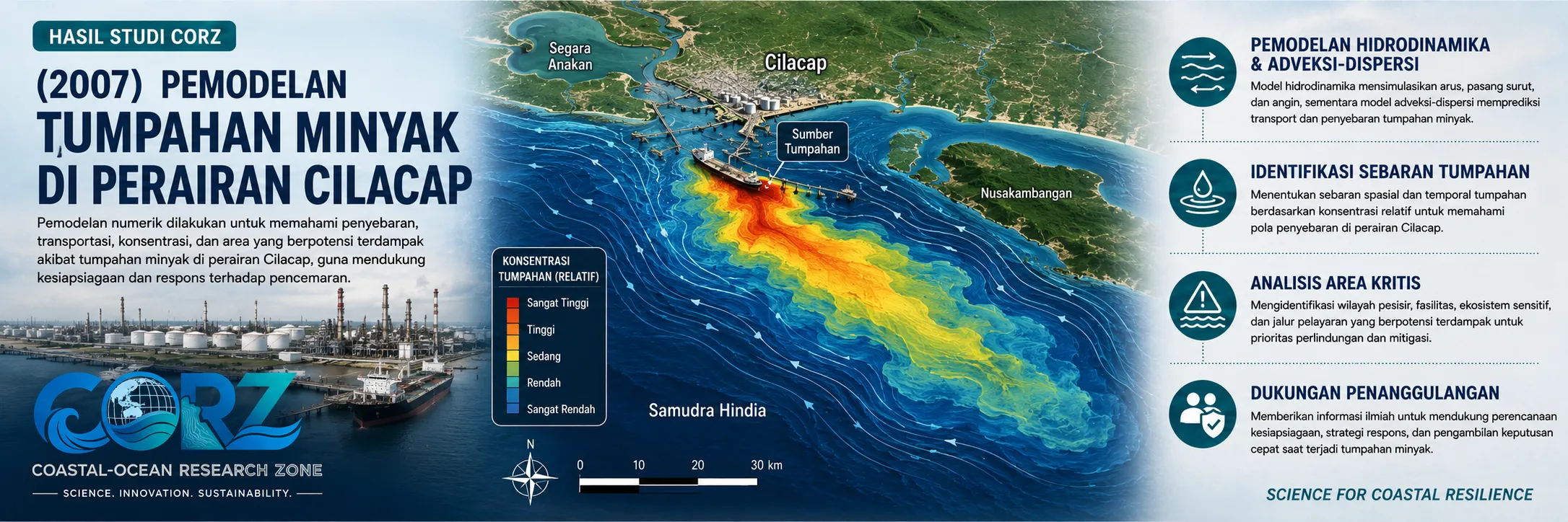
In 2007, CORZ Indonesia conducted a series of Research & Studies involving numerical oil-spill modelling in Cilacap waters, comparing three petroleum types under two major seasonal conditions.
The study consisted of:
- Crude Oil — West Monsoon
- Crude Oil — East Monsoon
- Diesel Oil — West Monsoon
- Diesel Oil — East Monsoon
- Gasoline — West Monsoon
- Gasoline — East Monsoon
The study therefore examined a single marine environment through six oil-spill scenarios, providing a broader perspective on how both oil properties and seasonal ocean conditions may influence spill behaviour.
Why Cilacap?
The relevance of such a study becomes clear when Cilacap's role in Indonesia's petroleum infrastructure is considered.
In July 2007, ANTARA reported plans to expand the Cilacap refinery, which at the time had a processing capacity of approximately 348,000 barrels per day.
ANTARA — Cilacap Refinery Expansion Plans, 13 July 2007
Then, on 29–30 December 2007—the same year as the CORZ modelling study—an oil spill was reported in the Teluk Penyu area of Cilacap. Fishermen participated in collecting oil from the coastal waters, while Pertamina investigated the source of the leak and the type of oil involved.
ANTARA — Pertamina Investigates Cilacap Oil Spill, 30 December 2007
These news reports were not reports about the CORZ study, nor should the modelling be interpreted as having predicted the incident.
Instead, the historical context demonstrates why oil-spill modelling is a practical requirement for coastal waters characterised by intensive petroleum and tanker operations.
Three Oil Types, Different Behaviour
One of the important features of the 2007 CORZ study was the decision not to represent all potential spills using a single petroleum type.
Three groups were modelled.
- Crude Oil
Crude-oil spill scenarios were simulated for both the West and East Monsoons.
Crude oils vary in composition and physical properties, while their behaviour after entering the ocean is influenced by transportation, spreading, mixing, evaporation, and other weathering processes.
Numerical modelling provides a means of examining how oil released from a given source can interact with the hydrodynamic circulation of Cilacap waters and develop a particular spatial trajectory.
The relevance of crude-oil scenarios was again demonstrated in May 2015, when leakage from a Single Point Mooring approximately 16 nautical miles south of Cilacap resulted in crude oil appearing in waters south of Nusakambangan. ANTARA reported that the spill was subsequently contained.
ANTARA — Crude-Oil Leakage South of Nusakambangan, 21 May 2015
- Diesel Oil
CORZ also developed diesel-oil spill scenarios for the West and East Monsoons.
Diesel differs physically and chemically from crude oil. These differences matter because the type of petroleum product can affect how the material spreads and changes after entering the marine environment.
The simulations allow the pathway:
SOURCE → TRANSPORT → DISPERSION → POTENTIAL EXPOSURE
to be examined and compared with crude-oil behaviour under the same hydrodynamic environment.
- Gasoline
The third petroleum category was gasoline.
Gasoline is generally lighter and more volatile than many crude oils. Modelling it independently is therefore important rather than assuming that every petroleum product behaves identically after release.
The fundamental message is straightforward:
Different oil, different behaviour.
Oil properties therefore need to be considered together with oceanographic conditions when assessing spill risk.
West Monsoon vs East Monsoon
Oil type is only one part of the problem.
The ocean itself changes.
Indonesia's monsoonal system produces seasonal variations in winds and coastal circulation. CORZ therefore modelled every petroleum category during both:
West Monsoon
and
East Monsoon conditions.
The principle is fundamental:
**SAME LOCATION
- SAME OIL
- DIFFERENT SEASON
= POTENTIALLY DIFFERENT SPILL TRAJECTORY**
A spill originating from the same location at different times of the year does not necessarily travel toward the same coastal area.
This is why an effective oil-spill assessment should not rely on only one oceanographic scenario.
Six Scenarios, One Marine System
The CORZ modelling programme can be summarised as:
CRUDE OIL
01 — Crude Oil | West Monsoon
02 — Crude Oil | East Monsoon
DIESEL OIL
03 — Diesel Oil | West Monsoon
04 — Diesel Oil | East Monsoon
GASOLINE
05 — Gasoline | West Monsoon
06 — Gasoline | East Monsoon
Together, they provide two analytical dimensions:
OIL TYPE × SEASON
This enables the marine environment to be evaluated without relying on a single pollutant type or a single seasonal condition.
From the Source to Potentially Exposed Areas
Conceptually, the modelling represents the pathway:
OIL RELEASE
↓
HYDRODYNAMIC CIRCULATION
↓
ADVECTION & DISPERSION
↓
OIL TRANSPORT
↓
SPATIAL SPREADING
↓
POTENTIAL EXPOSURE
Numerical modelling allows the evolving position of a spill to be investigated in both space and time.
The question therefore moves beyond:
“Where was the oil released?”
toward:
“Where could the oil travel after entering the sea?”
That distinction is critical for marine-pollution emergency management.
Real Incidents Demonstrate Why Modelling Matters
Oil-spill risk in Cilacap did not end with the incident reported in 2007.
In 2010, ANTARA again reported an oil-spill incident in the Cilacap–Nusakambangan area while Pertamina investigated a possible release associated with MFO loading operations to a tanker.
ANTARA — Oil Spill Investigation in Cilacap, 3 October 2010
Further incidents occurred in 2015. In addition to offshore crude-oil leakage, pollution reached the Teluk Penyu area, and The Jakarta Post subsequently reported fishermen seeking compensation after marine pollution disrupted their activities.
The Jakarta Post — Fishermen Seek Compensation Following Cilacap Oil Pollution, 12 September 2015
Then, in June 2022, crude oil was again observed in Cilacap waters. ANTARA reported residents and fishermen participating in clean-up operations around the Wijayapura wharf and Area 70.
Strong currents, winds, and high waves were reported to have contributed to the expansion of the affected area—an important real-world illustration of the relationship between oil transport and marine dynamics.
ANTARA — Oil Spill in Cilacap Waters, June 2022
These incidents were not events predicted by the 2007 CORZ modelling study.
Their significance lies elsewhere: they demonstrate why the capability to simulate oil transport remains strategically important for Cilacap.
Why Oil-Spill Modelling Matters
When an actual oil spill occurs, time becomes critical.
Decision-makers may need to determine:
Where is the oil likely to travel?
Which areas should receive priority protection?
Where might containment measures be considered?
Which environmentally sensitive areas lie along potential trajectories?
How could the response change under different ocean conditions?
Would a strategy appropriate for crude oil also be appropriate for diesel or gasoline?
Scenario-based modelling provides a scientific framework for addressing these questions before an emergency occurs or as part of preparedness planning.
From Simulation to Oil-Spill Decision Support
For CORZ Indonesia, an oil-spill model is more than an animation showing oil moving across a map.
Its true value lies in the decision-support information extracted from the simulation.
Oil-spill modelling can contribute to:
- Oil Spill Contingency Planning
- Emergency Response Planning
- Environmental Impact Assessment (EIA/AMDAL)
- Port & Terminal Risk Assessment
- Pipeline and SPM Studies
- Sensitive-Area Protection
- Coastal Environmental Management
- Scenario-Based Emergency Exercises
The modelling workflow can be represented as:
DATA
↓
HYDRODYNAMIC MODEL
↓
OIL CHARACTERISTICS
↓
SPILL SCENARIO
↓
TRAJECTORY & DISPERSION
↓
POTENTIAL EXPOSURE
↓
DECISION SUPPORT
A 2007 Study with Repeatedly Demonstrated Relevance
The CORZ study was conducted in 2007.
An oil spill was reported in Teluk Penyu later that same year.
Other incidents followed in 2010, 2015, and 2022.
This does not mean numerical modelling can tell us when an accidental spill will occur.
It can, however, help answer another highly important question:
If a spill occurs, what might the ocean do to the oil?
That is where hydrodynamic science, oil-spill modelling, and practical environmental management come together.
Model the Spill Before It Becomes an Impact.
Different oils have different characteristics.
The ocean changes.
The monsoon changes its circulation.
And a local release can become a wider coastal problem when its transport pathway is not understood.
The 2007 Cilacap study reflects the CORZ Indonesia approach:
Know the Oil.
Understand the Water.
Model the Spill.
Compare the Seasons.
Protect What Matters.
CORZ Indonesia for Research & Studies
Oil Spill Modelling • Hydrodynamic Modelling • Marine Pollution • Advection–Dispersion • Environmental Risk Assessment • Coastal & Ocean Modelling
Coastal-Ocean Research Zone (CORZ) Indonesia provides research, modelling, analysis, and technical solutions for coastal and ocean environments.
Email: info@corz.co.id
© 2026 CORZ Indonesia. All Rights Reserved.


