
CORZ Indonesia | Research & Studies
When Numerical Models Map the Current—and Tomography Observes the Ocean along a Path
Check out some other model outputs on YouTube @CORZIndonesia
Between the islands of Bali and Lombok lies a relatively narrow marine passage.
Yet the water moving through it forms part of a circulation system far larger than the strait itself.
The Lombok Strait is one of the principal exit passages of the Indonesian Throughflow (ITF), through which water from the Indonesian seas enters the Indian Ocean. Scientific studies also identify the strait as an important region for the generation of internal tides and nonlinear internal waves.
The ocean here is continuously changing.
Currents accelerate and weaken.
Tides reverse.
Water masses interact with complex bathymetry.
Internal waves propagate through the water column.
The scientific questions therefore become:
How does water circulate through the strait?
How do current direction and velocity change through time?
How does the seabed topography affect the flow?
How can observations collected along a tomography pathway be interpreted within the wider current field?
And how can numerical modelling and ocean observation work together to understand one of Indonesia's most important ocean passages?
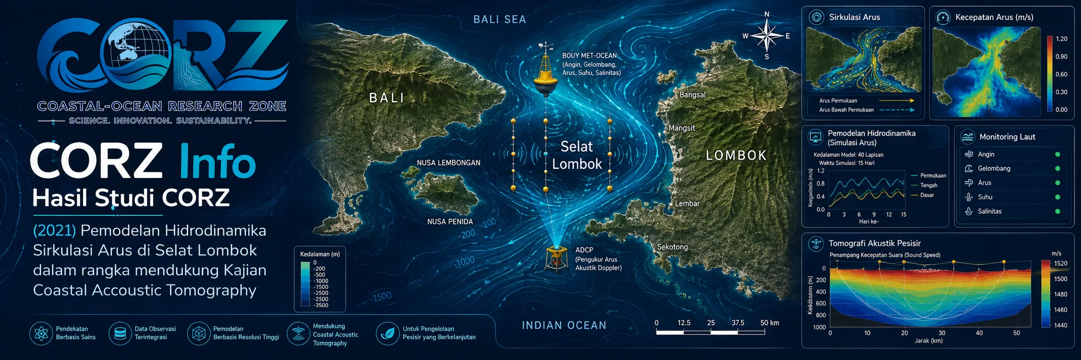
In 2021, CORZ Indonesia conducted Research & Studies involving:
Hydrodynamic Current-Circulation Modelling to Support a Tomography Study in the Lombok Strait.
The study places numerical hydrodynamics as a spatial and temporal physical framework for tomography-based observations.
The central idea is:
TOMOGRAPHY OBSERVES A PATH.
HYDRODYNAMIC MODELLING REPRESENTS THE SURROUNDING FLOW FIELD.
Together:
OBSERVATION + MODELLING → BETTER OCEAN UNDERSTANDING.
Lombok Strait: A Gateway between the Pacific and Indian Oceans
Indonesia forms a maritime connection between two great ocean basins.
Water entering the Indonesian seas from the Pacific ultimately exits toward the Indian Ocean through several pathways.
This system is known as the:
INDONESIAN THROUGHFLOW — ITF.
ANTARA, reporting on Indonesian oceanographic research, described Lombok Strait as one of the principal routes through which ITF water ultimately reaches the Indian Ocean.
ANTARA — Indonesian researchers investigate the Indonesian Throughflow
Scientific observations similarly identify Lombok Strait as one of the major ITF exits. Its circulation is strongly influenced by the Nusa Penida Sill near the southern part of the strait.
Lombok Strait is therefore not simply:
A CHANNEL BETWEEN BALI AND LOMBOK.
It forms part of:
A PACIFIC–INDIAN OCEAN EXCHANGE SYSTEM.
CORZ Research: Reconstructing the Current Field
Hydrodynamic modelling provides a numerical representation of water movement throughout the study domain.
Conceptually:
BATHYMETRY
+
TIDAL / OCEAN BOUNDARY CONDITIONS
+
HYDRODYNAMIC FORCING
↓
NUMERICAL HYDRODYNAMIC MODEL
↓
CURRENT DIRECTION & VELOCITY
↓
SPATIAL–TEMPORAL CURRENT FIELD
↓
PHYSICAL SUPPORT FOR TOMOGRAPHY ANALYSIS
Each current vector carries:
DIRECTION × VELOCITY × LOCATION × TIME.
A model therefore goes beyond answering:
“What is the current at one instrument?”
It provides a framework for asking:
“How does the entire strait move?”
Ocean Tomography: Observing the Water between Stations
One technology already demonstrated in Lombok Strait is Coastal Acoustic Tomography (CAT).
CAT uses underwater acoustic transmission between observation stations.
The transmitted acoustic signal travels through the ocean before being received at another station.
Conceptually:
ACOUSTIC STATION A
↓
SOUND THROUGH THE OCEAN
↓
ACOUSTIC STATION B.
Travel-time information contains information about the ocean medium crossed by the acoustic signal.
For reciprocal acoustic-current measurements:
A → B
B → A
↓
RECIPROCAL TRAVEL-TIME INFORMATION
↓
PATH-AVERAGED CURRENT INFORMATION
depending on the measurement configuration.
This makes tomography conceptually different from a single-point instrument.
It observes an ocean pathway.
Coastal Acoustic Tomography Has Already Demonstrated Its Potential in Lombok Strait
A particularly important scientific experiment was conducted in Lombok Strait from 27 to 29 February 2019.
Two bottom-mounted CAT systems observed the water column across an acoustic path approximately 18.286 km long.
The resulting research, published in Geophysical Research Letters, reconstructed four-layer temperature variations and detected the sequential passage of internal solitary waves. The reconstructed temperatures showed strong agreement with independent CTD observations.
Earlier feasibility work had also examined the potential application of CAT for long-term monitoring of Indonesian Throughflow transport variability through Lombok Strait.
This provides a strong scientific background for a 2021 hydrodynamic study supporting tomography.
Why Is a Hydrodynamic Model Still Needed?
Because an acoustic path is not the entire strait.
Suppose tomography observes:
STATION A ↔ STATION B.
That pathway may provide exceptionally useful integrated information.
But it does not automatically tell us:
What happens north of the acoustic line?
What happens south of it?
How does circulation evolve around Nusa Penida?
How does the current change through the tidal cycle?
How is the observed pathway connected to the larger ITF system?
Hydrodynamic modelling extends:
PATH INFORMATION
into:
FIELD INFORMATION.
Together:
TOMOGRAPHY OBSERVATION
NUMERICAL CURRENT FIELD
↓
A MORE COMPLETE PHYSICAL INTERPRETATION.
Sensors Measure. Models Provide Context.
This relationship is fundamental.
OBSERVATION
provides information from the real ocean.
MODELLING
places that information within a dynamically consistent spatial and temporal framework.
The strongest approach is therefore not:
MODEL vs OBSERVATION.
It is:
MODEL ↔ OBSERVATION.
Depending on the experiment and available data, the combination can support:
interpretation • validation • calibration • experiment planning • monitoring-system development.
Lombok Strait Is a Hotspot of Internal Ocean Dynamics
Scientific research published in 2021 confirmed that Lombok Strait is an important region for internal tides, nonlinear internal waves, and mixing.
The strait's topography interacts strongly with tidal motions, generating subsurface wave structures that can propagate through the water column.
This means that:
A CALM SURFACE DOES NOT NECESSARILY MEAN A SIMPLE OCEAN.
Below the surface there may be:
current shear • tidal oscillation • internal waves • vertical displacement • enhanced mixing.
Such dynamics make the Lombok Strait particularly valuable for integrated modelling and tomography studies.
Mainstream Media Also Highlighted Indonesia's Internal-Wave Research in 2021
In March 2021, ANTARA reported results from an Indonesian oceanographic expedition investigating active regions of internal-wave generation.
Lombok Strait was explicitly identified as one of the Indonesian waters where internal waves occur, alongside several other important ITF passages. The research also highlighted the importance of ocean mixing for understanding broader ocean and climate dynamics.
ANTARA — Indonesian expedition identifies active internal-wave regions
This report was not about the CORZ study.
Its importance here is contextual: subsurface dynamics within the Indonesian Throughflow system were an active focus of Indonesian marine science during the same period.
The Current Field Changes through Time
A single current map is only a snapshot.
The moving ocean requires:
CURRENT FIELD t₁
→
CURRENT FIELD t₂
→
CURRENT FIELD t₃
→
CURRENT FIELD tₙ.
This time dimension matters for tomography.
An acoustic signal transmitted through the same geographical path at different times may encounter a different ocean state.
Therefore:
SPACE MATTERS.
TIME MATTERS.
And modelling connects both.
Local Current, Strait Transport, Global Connection
Lombok Strait illustrates how different spatial scales are connected.
LOCAL CURRENT
forms part of:
STRAIT CIRCULATION,
which contributes to:
INDONESIAN THROUGHFLOW,
which connects:
PACIFIC OCEAN ↔ INDIAN OCEAN.
The sequence becomes:
LOCAL FLOW
↓
LOMBOK STRAIT TRANSPORT
↓
INDONESIAN THROUGHFLOW
↓
INTER-OCEAN EXCHANGE.
This is why understanding Lombok Strait has implications far beyond the channel between two islands.
Operationally, the Strait Is Dynamic as Well
The physical variability of the region is not only of academic interest.
In July 2021, BMKG warned of wave heights exceeding two metres in both northern and southern Lombok Strait waters.
ANTARA — BMKG warns of elevated waves in the Lombok Strait
In August, Indonesia's Ministry of Transportation issued a maritime warning during another period of severe weather, with 4–6 metre wave potential in the southern Bali–Lombok–Alas Strait region.
ANTARA — Transportation Ministry issues navigation warning during high-wave conditions
These reports do not validate the CORZ current model and concern surface-wave conditions rather than tomography.
They simply illustrate that Lombok Strait is an operationally dynamic marine environment as well as an oceanographically important one.
From Tomography to Long-Term Ocean Monitoring
One of the most promising directions for ocean tomography is sustained observation.
Traditional oceanographic instruments can provide highly precise local measurements.
Tomography provides an integrated view along an acoustic path.
Numerical modelling provides the surrounding spatial field.
Combined:
ACOUSTIC TOMOGRAPHY
↓
PATH-INTEGRATED OBSERVATION
↕
HYDRODYNAMIC MODEL
↓
SPATIAL CURRENT FIELD
↓
COMPARISON & PHYSICAL INTERPRETATION
↓
LONG-TERM OCEAN MONITORING.
Such an approach is relevant to research on:
Indonesian Throughflow variability • tidal circulation • internal waves • turbulent mixing • water-mass transport • ocean–climate interaction.
From Ocean Data to Ocean Intelligence
For CORZ Indonesia, numerical modelling is not simply about creating current animations.
The objective is to transform physical ocean information into a deeper understanding of the marine system.
The pathway becomes:
OCEAN OBSERVATION
BATHYMETRY & FORCING
↓
HYDRODYNAMIC MODELLING
↓
SPATIAL CURRENT FIELD
↔
TOMOGRAPHY
↓
PHYSICAL INTERPRETATION
↓
OCEAN INTELLIGENCE.
The direction is clear:
Do not choose between models and sensors.
Integrate them.
Don't Just Measure a Line. Understand the Flow Around It.
Tomography can observe the ocean along a pathway.
Hydrodynamic modelling places that pathway inside a wider moving sea.
In Lombok Strait—one of the principal gateways of the Indonesian Throughflow—the combination provides a powerful framework for understanding a complex and continuously changing marine system.
The 2021 Lombok Strait study reflects the CORZ Indonesia Research & Studies approach:
Model the Currents.
Observe the Path.
Understand the Tides.
Track the Variability.
Connect Local Flow with the Indonesian Throughflow.
Integrate Modelling and Observation.
Build Better Ocean Intelligence.
Because the question is not only:
“What does tomography measure along this line?”
The larger question is:
“How does that line fit into the movement of the entire strait?”
CORZ Indonesia for Research & Studies
Hydrodynamic Modelling • Current Circulation • Ocean Tomography Support • Coastal Acoustic Tomography • Indonesian Throughflow Studies • Internal-Wave Analysis • Ocean Monitoring
Coastal-Ocean Research Zone (CORZ) Indonesia provides research, modelling, analysis, and technical solutions for coastal and ocean environments.
YouTube: https://www.youtube.com/@CORZIndonesia
Website: https://corz.co.id
Email: info@corz.co.id
© 2026 CORZ Indonesia. All Rights Reserved.


