
CORZ Indonesia | Research & Studies
Before Tracking the Oil, Understand the Water That Carries It
An oil spill begins at a source.
Check out some other model outputs on YouTube @CORZIndonesia
Once petroleum enters the ocean, however, the problem no longer remains confined to that location.
The oil enters a moving marine system.
Currents transport water masses. Tides alter current velocity and direction. Wind can influence surface transport. Oil properties affect the way petroleum behaves once released.
The system evolves continuously through space and time.
Before asking:
“Where will the oil go?”
therefore, we need to answer a more fundamental physical question:
“Where is the water going?”
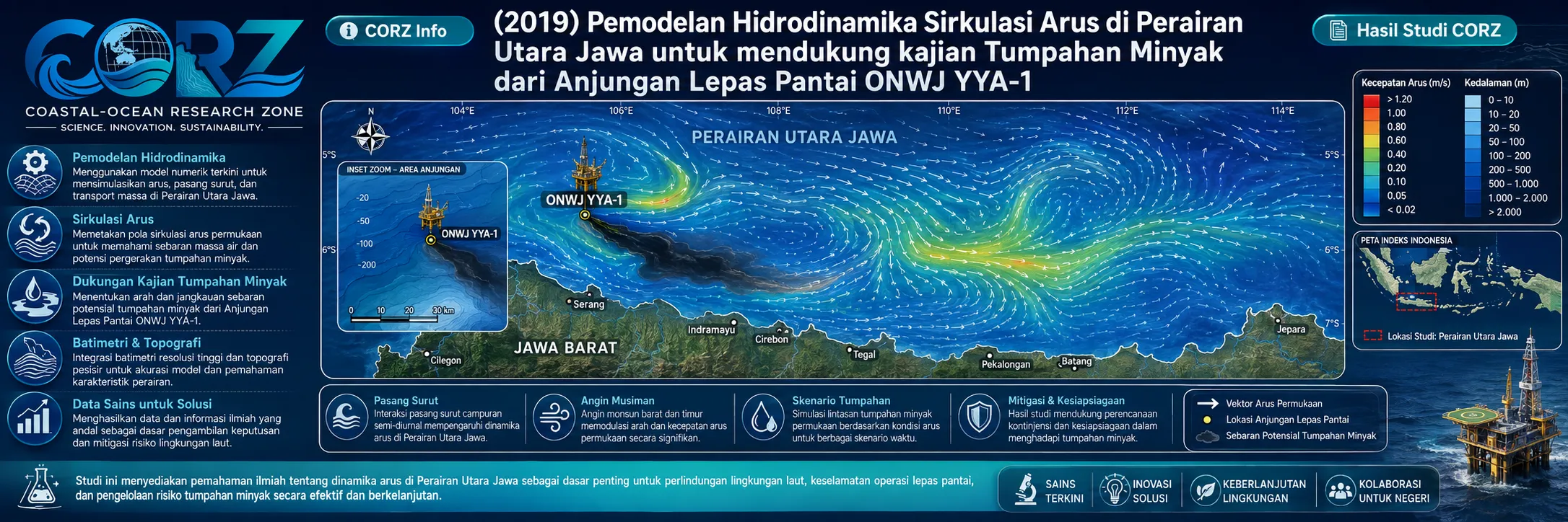
In 2019, CORZ Indonesia conducted Research & Studies involving hydrodynamic current-circulation modelling in the Java Sea to support assessment of the oil spill originating from the ONWJ YYA-1 offshore well.
The study positioned hydrodynamics as the physical foundation for understanding marine transport.
Its core framework is:
OCEAN FORCING → CURRENT CIRCULATION → WATER-MASS TRANSPORT → POTENTIAL OIL TRANSPORT
YYA-1 2019: When an Offshore Well Incident Became a Coastal Pollution Problem
In July 2019, an incident developed at the YYA-1 well within the PHE Offshore North West Java block off Karawang.
ANTARA reported that gas bubbles appeared during re-entry and re-perforation activities. Workers were subsequently evacuated; an oil sheen was observed on the sea surface on 16 July, and by 18 July spilled oil had begun reaching the coastline west of the offshore facility.
ANTARA — Investigation of the YYA-1 offshore well incident in the Java Sea
The Jakarta Post reported that the reactivated YYA-1 well experienced a well kick on 12 July, followed by gas release and an oil spill.
What began as an offshore engineering incident therefore became a much larger oceanographic question:
Where would the oil be transported?
How were the offshore well and the northern Java coastline connected by water movement?
How would circulation evolve through time?
And which receiving waters could become connected with the source?
This is precisely where hydrodynamic modelling becomes essential.
CORZ Research: Modelling the Ocean's Invisible Transport Network
Currents can be considered the ocean's invisible transport network.
Oil is one of many materials capable of travelling through that network.
Knowing the release coordinate tells us:
WHERE THE EVENT STARTED.
It does not yet tell us:
WHERE THE OCEAN MAY CARRY IT.
CORZ hydrodynamic modelling provides a spatial and temporal representation of marine circulation.
Conceptually:
BATHYMETRY + TIDAL / OCEAN BOUNDARY FORCING
↓
HYDRODYNAMIC MODEL
↓
CURRENT DIRECTION & VELOCITY
↓
SPATIAL–TEMPORAL CURRENT FIELD
↓
PHYSICAL BASIS FOR OIL-SPILL ASSESSMENT
Each modelled current vector contains:
DIRECTION × VELOCITY × LOCATION × TIME.
Together, these vectors reveal how water masses connect different parts of the Java Sea.
Hydrodynamics Is Not the Oil-Spill Model—It Is Its Physical Foundation
This distinction is scientifically important.
A:
HYDRODYNAMIC MODEL
primarily addresses:
How does the water move?
An oil-spill model can subsequently address:
How does petroleum move and transform within that moving water?
The analytical chain becomes:
HYDRODYNAMICS
↓
CURRENT FIELD
↓
ADVECTION / TRANSPORT
↓
OIL-SPILL TRAJECTORY & FATE PROCESSES
The CORZ hydrodynamic study therefore should not be interpreted as providing unspecified oil concentrations, slick thicknesses, shoreline-arrival times, or exposure values.
Its core result is the physical transport framework required to support such analyses.
To track the oil, first understand the water that carries it.
From One Offshore Platform to the Northern Java Coast
Geographical distance alone cannot fully explain oil-spill transport.
Two locations at similar distances from a source may have very different relationships with the spill because their hydrodynamic connectivity is different.
Therefore:
DISTANCE ≠ HYDRODYNAMIC CONNECTIVITY.
A more physically meaningful framework is:
SOURCE → CURRENT PATHWAY → RECEPTOR.
This is one of the fundamental reasons numerical circulation modelling matters in marine-pollution assessment.
Field Reports Demonstrated the Transport Problem
The shoreline consequences became visible within days.
On 23 July 2019, ANTARA reported clean-up operations involving crude-oil residues mixed with sand on the Karawang coastline.
By 24 July, authorities reported impacts across seven coastal villages in Karawang.
On 27 July, ANTARA reported that oil had spread into several river mouths along the northern Karawang coast.
ANTARA — Oil from the offshore leak spreads into river mouths along the Karawang coast
By the end of July, The Jakarta Post reported impacts affecting at least 10 villages and seven beaches across Karawang and Bekasi.
These observations are external field evidence and should not be presented as quantitative validation of the CORZ hydrodynamic model.
Their significance is broader: they demonstrate why understanding marine transport pathways is critical during a large offshore pollution event.
Pollution Does Not Follow Administrative Boundaries
Oil does not recognise the boundaries between:
Karawang • Bekasi • Jakarta • Banten.
It follows the physical marine system.
By September 2019, The Jakarta Post reported that oil associated with the ONWJ incident had reached nine islands in the Thousand Islands Regency, including Untung Jawa and Lancang.
The Jakarta Post — Fishermen catch oil, not fish, after well accident
The case illustrates an essential principle:
A pollution source may be local. Its transport pathway can become regional.
Current Vectors Are More Than Arrows on a Map
Hydrodynamic results are often visualised through current vectors.
Each arrow represents a physical state of the marine system.
But the greater value emerges when the field is examined through time:
CURRENT FIELD t₁
↓
CURRENT FIELD t₂
↓
CURRENT FIELD t₃
↓
CURRENT FIELD tₙ
A substance released during one current condition may encounter a different circulation pattern several hours later.
Transport is therefore not simply:
WHERE?
It is:
WHERE + WHEN?
This is what makes time-dependent hydrodynamic modelling fundamental to spill assessment.
Current Direction and Current Speed Work Together
Current direction answers:
Where could water carry the material?
Current speed contributes to:
How rapidly could the water transport it?
Neither should be interpreted alone.
The complete current vector contains:
DIRECTION + VELOCITY.
Adding its spatial and temporal dimensions produces:
DIRECTION + VELOCITY + SPACE + TIME.
This is the physical information required for increasingly sophisticated pollutant-transport analysis.
From Hydrodynamics to Oil-Spill Decision Support
Within a broader assessment framework:
INCIDENT / RELEASE LOCATION
↓
METEOROLOGICAL & OCEANOGRAPHIC INFORMATION
↓
HYDRODYNAMIC MODELLING
↓
CURRENT CIRCULATION
↓
OIL-SPILL MODELLING
↓
TRAJECTORY / EXPOSURE
↓
SHORELINE & ENVIRONMENTAL RECEPTORS
↓
RESPONSE DECISION SUPPORT
Such information can support oil-spill contingency planning, emergency response, offshore oil-and-gas environmental studies, shoreline protection, sensitive-area assessment, and marine-pollution analysis.
A model does not replace field observations.
It can help determine:
Where should observations and response be directed next?
The YYA-1 Response Demonstrated the Scale of a Real Offshore Emergency
The response became a major operation.
The Jakarta Post reported the deployment of numerous vessels and the involvement of international well-control specialist Boots & Coots in efforts to control YYA-1.
ANTARA reported layered containment measures, including oil booms and efforts to localise and recover escaped oil.
A relief well, YYA-1RW, was subsequently drilled. ANTARA reported that it successfully intercepted YYA-1 on 21 September 2019, allowing the well-control operation to move into its next critical stage.
ANTARA — YYA-1 brought under control after relief-well interception
A real incident therefore requires the integration of:
FIELD RESPONSE + ENGINEERING + OCEAN OBSERVATION + MODELLING.
From Current Data to Environmental Intelligence
At CORZ Indonesia, a current model is more than a moving field of arrows.
The objective is to transform ocean dynamics into usable environmental information.
The pathway is:
BATHYMETRY & OCEANOGRAPHIC DATA
↓
HYDRODYNAMIC SIMULATION
↓
CURRENT CIRCULATION
↓
TRANSPORT PATHWAYS
↓
OIL-SPILL ASSESSMENT SUPPORT
↓
ENVIRONMENTAL INTELLIGENCE
The same physical capability is also relevant to:
sediment transport • pollutant dispersion • marine outfalls • floating debris • search and rescue • larval transport • coastal connectivity
because each ultimately asks the same physical question:
Where does the water carry it?
Before Tracking the Oil, Model the Water.
The incident begins at an offshore well.
Oil enters the Java Sea.
The moving ocean determines the physical pathways available to it.
The 2019 Northern Java study reflects the CORZ Indonesia Research & Studies approach:
Identify the Source.
Model the Currents.
Understand the Water-Mass Pathways.
Support the Spill Assessment.
Connect Offshore Events with Coastal Receptors.
Transform Hydrodynamics into Decision Support.
Because before we can reliably investigate:
“Where will the oil go?”
we need to understand:
“Where is the water going?”
CORZ Indonesia for Research & Studies
Hydrodynamic Modelling • Current Circulation • Oil Spill Assessment Support • Offshore Environmental Studies • Marine Pollution • Coastal Connectivity Analysis
Coastal-Ocean Research Zone (CORZ) Indonesia provides research, modelling, analysis, and technical solutions for coastal and ocean environments.
YouTube: https://www.youtube.com/@CORZIndonesia
Website: https://corz.co.id
Email: info@corz.co.id
© 2026 CORZ Indonesia. All Rights Reserved.


