
CORZ Indonesia | Research & Studies
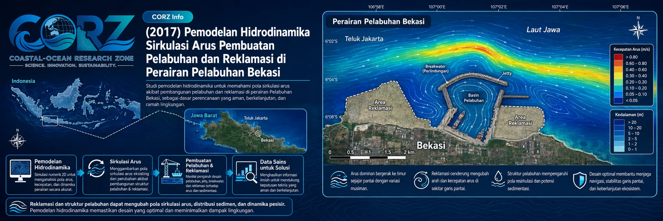
When the Coastline Changes, the Water May Respond
Check out some other model outputs on YouTube @CORZIndonesia
Coastal development takes place within a moving physical system.
Reclamation changes the land–water boundary. Port development introduces new geometry into the marine environment. Areas previously occupied by water may become land, while port facilities modify the space through which currents circulate.
The engineering question is therefore not simply:
“Can the reclamation and port be constructed?”
The oceanographic questions are:
How will the water move after construction?
Will current pathways change?
Will velocity increase or decrease in particular areas?
Will new local circulation patterns develop?
And how can the effects of reclamation be distinguished from those of port development?
In 2017, CORZ Indonesia conducted Research & Studies involving hydrodynamic current-circulation modelling in Bekasi coastal waters, using four development configurations.
| Scenario | Reclamation | Port | Analytical Purpose |
| 01 — Baseline | Before | Before | Establish the reference hydrodynamic condition |
| 02 — Port Only | Before | After | Isolate the influence of port development |
| 03 — Reclamation Only | After | Before | Isolate the influence of reclamation |
| 04 — Combined Development | After | After | Evaluate the combined configuration |
This makes the study more than a current simulation.
It becomes a numerical experiment in coastal transformation.
Four Models to Answer One Fundamental Question
The modelling concept can be expressed as:
EXISTING COASTAL WATERS
↓
MODIFY THE COASTLINE?
↓
INTRODUCE THE PORT?
↓
SIMULATE THE HYDRODYNAMICS
↓
COMPARE CURRENT DIRECTION & VELOCITY
↓
UNDERSTAND THE RESPONSE OF THE WATER
Importantly, the two physical interventions are not evaluated only as a single combined development.
They are also modelled independently.
This enables more structured questions:
What does the port change?
What does reclamation change?
What happens when both are present?
Scenario 1 — Before Reclamation, Before Port Development
The first scenario represents the:
BASELINE CONDITION.
Neither reclamation nor port development is introduced into the model geometry.
This reference simulation establishes the original circulation environment through parameters such as:
CURRENT DIRECTION + CURRENT VELOCITY + SPATIAL CIRCULATION + TEMPORAL VARIABILITY
The baseline is essential because changes cannot be objectively assessed without a reference condition.
Before evaluating change, understand the original system.
Scenario 2 — Before Reclamation, After Port Development
The second configuration introduces the port while keeping the unreclaimed coastal configuration.
Conceptually:
RECLAMATION = OFF
PORT = ON
This isolates the response associated with port geometry.
A new marine structure or port configuration can modify the available flow space and create new boundaries for the moving water.
The analytical pathway becomes:
EXISTING CURRENT FIELD
↓
PORT GEOMETRY INTRODUCED
↓
HYDRODYNAMIC RESPONSE
↓
MODIFIED LOCAL CIRCULATION?
Comparison with the baseline allows changes represented by the numerical model to be evaluated systematically.
Scenario 3 — After Reclamation, Before Port Development
The third experiment reverses the configuration:
RECLAMATION = ON
PORT = OFF
The purpose is to investigate the influence of reclamation independently.
Reclamation changes the:
LAND–WATER BOUNDARY.
Water that previously occupied part of the coastal domain is displaced by a new land configuration.
Conceptually:
ORIGINAL COASTLINE
↓
RECLAMATION
↓
MODIFIED COASTLINE
↓
MODIFIED FLOW SPACE
↓
HYDRODYNAMIC RESPONSE
The model therefore provides a framework for asking how coastal geometry itself influences circulation.
Scenario 4 — After Reclamation, After Port Development
The fourth scenario represents the full development configuration:
RECLAMATION = ON
PORT = ON.
Having already evaluated the two interventions independently, CORZ can then examine their combined hydrodynamic setting.
The key question becomes:
Does the combined response simply resemble the separate effects?
or:
Does the interaction between both geometrical changes create a different circulation pattern?
That should not be assumed from the layout alone.
It needs to be simulated.
A 2 × 2 Hydrodynamic Scenario Matrix
Scientifically, the scenario design is particularly valuable.
There are two development variables:
RECLAMATION — BEFORE / AFTER
and:
PORT — BEFORE / AFTER
creating a:
2 × 2 SCENARIO MATRIX.
The model can therefore compare:
BASELINE → PORT ONLY
to investigate the port effect;
BASELINE → RECLAMATION ONLY
to investigate the reclamation effect;
and:
BASELINE → RECLAMATION + PORT
to investigate the complete development condition.
This provides greater analytical value than a simple:
BEFORE vs AFTER
comparison.
The objective is not only to determine whether the current field changes, but to provide a framework for understanding which physical modification is associated with that change.
2017: Maritime Connectivity Was Becoming Increasingly Important for Bekasi
The historical context strongly reinforces the relevance of such modelling.
On 27 April 2017, ANTARA reported that Indonesia's Transportation Minister and Public Works Minister inspected the planned Cikarang–Bekasi–Laut Inland Waterway (CBL), travelling by boat along the route. The project was intended to provide an alternative cargo connection between industrial areas and the Tanjung Priok logistics network.
ANTARA — CBL Inland Waterway Development, 27 April 2017
In May, ANTARA reported expectations that the waterway could eventually shift a substantial portion of container traffic from roads to barges, connecting Tanjung Priok with the Cikarang, Cibitung, and Karawang industrial areas.
ANTARA — Cikarang–Bekasi–Laut Waterway and Container Transport, 12 May 2017
detikFinance subsequently reported continued preparation for the approximately 19-km CBL waterway project and its associated terminal infrastructure.
detikFinance — Cikarang Bekasi Laut Project Prepared for Development
These reports were not about the CORZ study and do not establish that the CORZ model represented the CBL project.
Their relevance is historical: in 2017, Bekasi was increasingly part of an interconnected industrial–waterway–coastal–port development environment.
Port Infrastructure Was Also Expanding on the Bekasi Coast
A further development occurred on 24 May 2017, when Indonesia's Directorate General of Sea Transportation signed a concession agreement covering Marunda Center Terminal in Bekasi, establishing it as a public terminal.
Indonesia Ministry of Transportation — Marunda Center Terminal Concession, 24 May 2017
The terminal operator's documented milestones indicate that Terminal 1B construction had started in June 2016 and operations began in August 2017; the facility is located in Bekasi approximately 9 km east of Tanjung Priok.
This information does not establish that Marunda Center Terminal was the specific port represented in the CORZ modelling study.
It does, however, demonstrate that coastal Bekasi was undergoing substantial maritime-infrastructure development during the same period.
Why Model the Currents Before Changing the Coast?
Water moves through the physical space available to it.
When that space changes, the circulation may respond.
The underlying relationship can be expressed as:
COASTLINE + BATHYMETRY + TIDAL / BOUNDARY FORCING
↓
CURRENT CIRCULATION
Introduce:
RECLAMATION
or:
PORT GEOMETRY
and the system becomes:
MODIFIED COASTLINE + MODIFIED FLOW SPACE
↓
POTENTIALLY MODIFIED CURRENT CIRCULATION
The magnitude and spatial pattern of that response should be determined from simulation and observation—not assumed.
That is why CORZ modelling does not need to claim in advance that currents necessarily become faster or slower.
The model is used to find out.
Current Vectors: Turning Development into Measurable Hydrodynamic Response
A hydrodynamic model produces a spatial current field.
Each current vector contains:
DIRECTION × VELOCITY × LOCATION × TIME
The greatest value emerges when the scenario results are compared.
Scenario 01 vs Scenario 02 provides information about the response associated with port development.
Scenario 01 vs Scenario 03 provides information about reclamation.
Scenario 01 vs Scenario 04 provides the overall development perspective.
The research output is therefore more than four current animations.
Its core value is:
COMPARATIVE HYDRODYNAMIC INFORMATION.
From Engineering Layout to Hydrodynamic Consequence
A coastal engineering layout may look convincing on a plan.
But that layout will ultimately exist within moving water.
A stronger design workflow therefore becomes:
ENGINEERING LAYOUT
↓
DIGITAL COASTAL GEOMETRY
↓
HYDRODYNAMIC MODELLING
↓
CURRENT RESPONSE
↓
SCENARIO COMPARISON
↓
DESIGN & ENVIRONMENTAL INSIGHT
Numerical modelling connects:
WHAT WE PLAN TO BUILD
with:
HOW THE WATER MAY RESPOND.
More Than Before vs After
One of the most distinctive features of the 2017 Bekasi study is that it does not rely only on:
BEFORE
and:
AFTER.
Instead, it evaluates:
BASELINE
PORT ONLY
RECLAMATION ONLY
PORT + RECLAMATION
This provides a much stronger framework for evaluating complex coastal development.
If only the initial and final configurations were compared, a difference might be visible—but separating the effects of individual interventions would be more difficult.
The four-scenario framework allows numerical modelling to serve not merely as an ocean simulation tool, but as a design-testing tool.
From Hydrodynamic Modelling to Coastal and Port Decision Support
This type of modelling can support reclamation impact assessment, port master planning, harbour development, navigation studies, sedimentation assessment, environmental impact assessment, water-quality studies, coastal infrastructure planning, and marine spatial planning.
It enables decision-makers to ask:
What changes if only the port is developed?
What changes if only reclamation takes place?
How does the combined configuration compare?
Which parts of the waterbody are most sensitive to geometrical modification?
Should the development layout be further evaluated or optimised?
This is where:
MODEL → COMPARISON → UNDERSTANDING → BETTER DECISION.
Four Scenarios. One Question: How Will the Water Respond?
Reclamation changes the boundary.
A port changes the marine space.
The water responds according to physics.
The 2017 Bekasi coastal study reflects the CORZ Indonesia Research & Studies approach:
Model the Baseline.
Add the Port.
Add the Reclamation.
Combine the Development.
Compare the Currents.
Understand the Consequences.
Support Better Coastal Decisions.
Because coastal development should not ask only:
“What will we build?”
It should also ask:
“How will the water respond when we build it?”
CORZ Indonesia for Research & Studies
Hydrodynamic Modelling • Reclamation Impact Assessment • Port Development Studies • Current Circulation • Coastal Infrastructure Modelling • Environmental Impact Assessment
Coastal-Ocean Research Zone (CORZ) Indonesia provides research, modelling, analysis, and technical solutions for coastal and ocean environments.
YouTube: https://www.youtube.com/@CORZIndonesia
Website: https://corz.co.id
Email: info@corz.co.id
© 2026 CORZ Indonesia. All Rights Reserved.


