
CORZ Indonesia | Research & Studies
When Numerical Modelling Meets a Technology That “Listens” to the Ocean
Check out some other model outputs on YouTube @CORZIndonesia
Balikpapan Bay is far more than a body of water between Balikpapan and Penajam.
It is a complex coastal system connected to rivers, estuaries, mangroves, industrial zones, ports, shipping activities, energy infrastructure, and the Makassar Strait.
Water movement within such a system is inherently dynamic.
Tides alter current direction and velocity. Bay geometry constrains water transport. Rivers introduce freshwater and material from land, while intensive human activities operate within the same continuously moving marine environment.
The scientific questions therefore include:
How does circulation within Balikpapan Bay work?
How rapidly does it change?
How are different parts of the bay hydrodynamically connected?
And, more innovatively:
Can underwater sound be used to observe those currents?
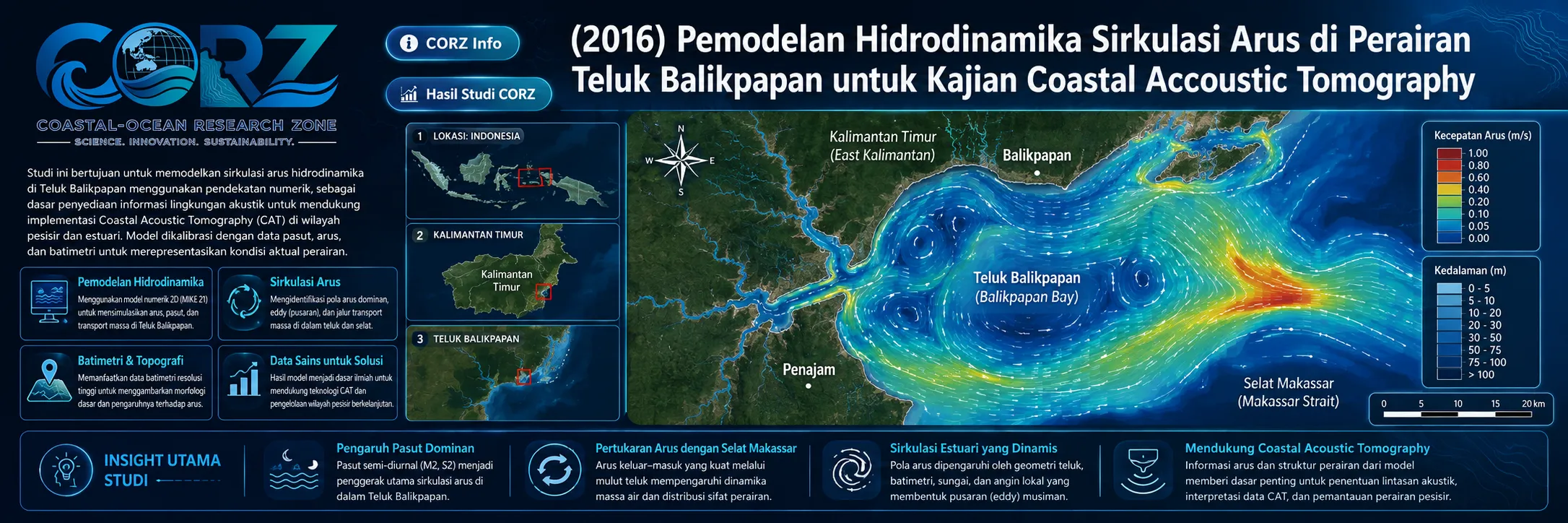
In 2016, CORZ Indonesia conducted Research & Studies involving:
Hydrodynamic Modelling to Support the Application of Coastal Acoustic Tomography in Balikpapan Bay.
The numerical model provided spatial and temporal representations of current circulation to support the understanding, evaluation, and potential application of Coastal Acoustic Tomography (CAT).
Coastal Acoustic Tomography: Measuring the Ocean through Sound Travel Time
Coastal Acoustic Tomography uses reciprocal underwater acoustic transmissions between observation stations.
Sound travelling with the current experiences a slightly different travel time from sound travelling against the current.
Conceptually:
ACOUSTIC STATION A → STATION B
+
ACOUSTIC STATION B → STATION A
↓
RECIPROCAL TRAVEL-TIME DIFFERENCE
↓
PATH-AVERAGED CURRENT
This provides a fundamentally different perspective from conventional single-point current measurements.
Rather than observing only what occurs at an instrument location, CAT can provide information integrated along the acoustic transmission pathway.
The technology was actively being developed for monitoring coastal circulation and strait throughflow in the Indonesian archipelago during this period.
Why Combine CAT with a Hydrodynamic Model?
Ocean observations and numerical simulations answer complementary questions.
CAT asks:
What happened along this acoustic pathway?
Hydrodynamic modelling asks:
How does that observation fit into the entire circulation system?
The combination becomes:
OBSERVATION + MODELLING = MORE COMPLETE OCEAN UNDERSTANDING
A numerical model provides information on:
- current direction;
- current velocity;
- tidal variability;
- spatial circulation patterns;
- water-mass connectivity; and
- areas outside the acoustic measurement paths.
CAT observations can therefore be interpreted within a wider hydrodynamic context rather than as isolated measurements.
From an Acoustic Path to a Current Field
Imagine two CAT stations separated across part of the bay.
The acoustic system provides information along:
A ↔ B
But what happens north of the path?
What happens south of it?
Does the water circulate locally?
How does that section communicate with the inner and outer bay?
Numerical modelling extends:
ONE ACOUSTIC PATH
into:
A SPATIAL CURRENT FIELD
With several acoustic stations, modelling and observation can increasingly support:
VALIDATION • INTERPRETATION • CALIBRATION • MONITORING DEVELOPMENT
This is one of the major advantages of integrated observational–numerical oceanography.
Coastal Acoustic Tomography Was Subsequently Applied in Balikpapan Bay
The scientific context is particularly relevant.
Research subsequently documented the development of Coastal Acoustic Tomography for monitoring sea temperature and currents in Balikpapan Bay. The work used a network of four acoustic stations and incorporated hydrodynamic modelling to compare reconstructed current information.
A later peer-reviewed publication demonstrated successful reconstruction of Balikpapan Bay sea temperature using the four-station CAT network, with the reported temperature validation exceeding 97–98% against CTD observations for the analysed parameter.
Scientific publication — Mapping Sea Temperature of Balikpapan Bay Using Coastal Acoustic Tomography
This provides strong independent scientific context for the value of integrating acoustic observation and numerical modelling in Balikpapan Bay.
2016: A Bay under Increasing Development Pressure
The study also took place during a period of significant activity around Balikpapan Bay.
In January 2016, ANTARA reported environmental concerns surrounding rapid industrial expansion, coastal development, and reclamation around the bay.
ANTARA — Industrial Expansion Threatens Balikpapan Bay, 25 January 2016
Later that year, Balikpapan authorities planned to reactivate Somber Port and redistribute some vessel activity to address congestion around Kariangau. ANTARA described intensive ferry and cargo activity across the local waters.
ANTARA — Balikpapan Plans to Reactivate Somber Port, 21 September 2016
These reports were not reports about the CORZ study.
They provide the broader context for why better marine observation matters:
more coastal activity requires better ocean information.
Why Do Currents Matter?
Current circulation influences far more than basic physical oceanography.
It is directly relevant to:
POLLUTANT TRANSPORT • OIL-SPILL DISPERSION • SEDIMENT TRANSPORT • NAVIGATION • WATER EXCHANGE • MARINE OUTFALLS • PORT OPERATIONS • ECOSYSTEM CONNECTIVITY • SEARCH & RESCUE
Balikpapan Bay therefore represents exactly the type of environment where improved understanding of current circulation can support many different sectors.
The objective is not simply to produce arrows on a screen.
It is to understand how different parts of the bay are connected by moving water.
From Monitoring to Ocean Intelligence
For CORZ Indonesia, the future of ocean monitoring is not simply about deploying more instruments.
It is about connecting observations with numerical understanding.
The integrated pathway is:
COASTAL ACOUSTIC TOMOGRAPHY
↓
OCEAN OBSERVATION
↕
HYDRODYNAMIC MODELLING
↓
SPATIAL CURRENT FIELD
↓
VALIDATION & DATA INTEGRATION
↓
MARINE MONITORING
↓
OCEAN INTELLIGENCE
Such an approach can support:
Marine Monitoring • Port Operations • Environmental Assessment • Pollution Response • Sediment Studies • Navigation • Coastal Planning • Search & Rescue • Long-Term Ocean Observation
Models do not replace observations.
Observations do not replace models.
They make each other more useful.
Don't Just Measure the Bay. Understand How It Moves.
Balikpapan Bay may appear calm from the surface.
Beneath it, the water is always moving.
Acoustics can help us observe movement along a marine pathway.
Numerical modelling allows us to see the larger system.
The 2016 Balikpapan Bay study reflects the CORZ Indonesia Research & Studies approach:
Transmit the Sound.
Measure the Current.
Model the Circulation.
Compare Observation and Simulation.
Understand the Connectivity.
Transform Data into Ocean Intelligence.
Because the ultimate objective is not merely to determine:
“How fast is the current here?”
It is to understand:
“How does the entire bay move?”
CORZ Indonesia for Research & Studies
Hydrodynamic Modelling • Coastal Acoustic Tomography Support • Current Circulation • Tidal Dynamics • Ocean Observation • Marine Monitoring & Environmental Analysis
Coastal-Ocean Research Zone (CORZ) Indonesia provides research, modelling, analysis, and technical solutions for coastal and ocean environments.
YouTube — CORZ Indonesia
Website — CORZ Indonesia
Email: info@corz.co.id
© 2026 CORZ Indonesia. All Rights Reserved.


