
CORZ Indonesia | Research & Studies
Modelling the Current—and Using Sound to Observe It
Check out some other model outputs on YouTube @CORZIndonesia
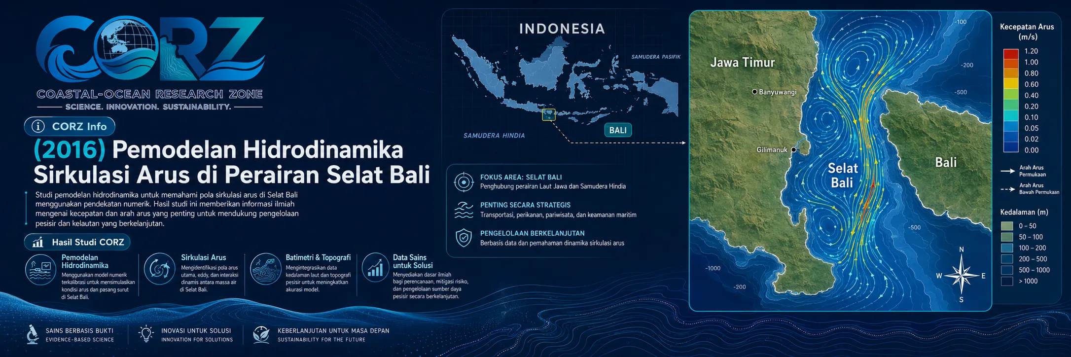
The Bali Strait is a narrow, dynamic, and strategically important marine corridor separating Java and Bali.
At the surface, ferries continuously cross between Ketapang and Gilimanuk.
Beneath them, water masses move through a considerably more complex hydrodynamic system influenced by tides, bathymetry, coastline geometry, sea-level variability, and the marine environments at both ends of the strait.
The scientific question therefore extends beyond:
“Which direction does the current flow?”
It becomes:
How rapidly does the current change? How does velocity vary across the strait? Can a measurement at one location adequately represent the system? And can underwater sound be used to observe currents across an entire section of the sea?
In 2016, CORZ Indonesia conducted Research & Studies involving hydrodynamic current-circulation modelling in the Bali Strait to support studies on the application of Coastal Acoustic Tomography (CAT).
The modelling was conducted at two complementary spatial scales:
- Detailed hydrodynamic modelling for the CAT study area
- Hydrodynamic modelling across the wider Bali Strait
Together, these approaches provide:
ZOOM IN — detailed understanding of the observation area
and:
ZOOM OUT — understanding how that area functions within the entire strait system.
Coastal Acoustic Tomography: When Sound Becomes an Oceanographic Instrument
Coastal Acoustic Tomography is an ocean-observation technique that uses underwater sound transmission between acoustic stations to measure characteristics of the marine environment.
Its fundamental principle is elegant.
Sound is transmitted from one station to another and then reciprocally in the opposite direction.
Ocean currents influence acoustic travel time.
A sound signal travelling with the current experiences a slightly different travel time from one travelling against it.
The difference between reciprocal travel times can therefore be converted into path-averaged current velocity. Combined travel-time information can also provide information on sound speed, which is related principally to water temperature and salinity.
Conceptually:
ACOUSTIC TRANSMISSION A → B
+
ACOUSTIC TRANSMISSION B → A
↓
RECIPROCAL TRAVEL-TIME DIFFERENCE
↓
PATH-AVERAGED CURRENT
This differs fundamentally from a single-point current measurement.
CAT does not observe only what happens at the instrument—it integrates information along the acoustic transmission path.
Why Combine CAT with Hydrodynamic Modelling?
Observations and numerical models should not be seen as competing approaches.
Their greatest value emerges when they are combined.
OBSERVATION tells us what the ocean did.
MODELLING helps us understand where, why, and how it happened.
Hydrodynamic modelling can provide important context for CAT by describing:
- expected current-circulation patterns;
- current direction and velocity;
- tidal variability;
- spatial relationships between the CAT study area and the broader strait;
- physical interpretation of acoustic transmission paths; and
- the wider current field surrounding path-averaged CAT observations.
The integrated concept is therefore:
MODEL + OBSERVATION → BETTER OCEAN UNDERSTANDING.
- Detailed Hydrodynamic Modelling
The first component was:
Detailed Hydrodynamic Modelling for the Coastal Acoustic Tomography Study
A detailed model provides higher-resolution information around the target observation area.
The simulations can characterise:
current direction • current velocity • tidal variation • local circulation • hydrodynamic connectivity
CAT provides information along acoustic transmission paths.
The model provides a current field surrounding those paths.
Thus:
CAT PATH INFORMATION
can be interpreted within a:
2-D / 3-D HYDRODYNAMIC CONTEXT.
The ocean is no longer represented only by a line connecting two acoustic stations.
The surrounding circulation becomes visible as a physical system.
- Hydrodynamic Modelling of the Entire Bali Strait
The second component expands the domain to:
The Wider Bali Strait Hydrodynamic System
Why is this important?
Because currents measured within a local observation area form part of a larger water-mass transport system.
The full-domain model allows broader questions to be investigated:
Where does the water come from?
How does flow respond as it enters narrower sections of the strait?
How does velocity vary along the channel?
How are local observations related to the circulation of the wider region?
The distinction can be expressed as:
DETAIL MODEL = WHAT HAPPENS HERE?
FULL-STRAIT MODEL = HOW DOES IT FIT INTO THE SYSTEM?
Combining the two produces a more complete hydrodynamic interpretation.
In 2016, Coastal Acoustic Tomography Was Actually Deployed in the Bali Strait
The scientific context is particularly compelling.
A four-station Coastal Acoustic Tomography experiment was conducted in the northern Bali Strait from 1–3 June 2016.
Reciprocal acoustic observations were obtained along four transmission paths during an approximately 30-hour measurement period.
Results subsequently published in Estuarine, Coastal and Shelf Science identified semidiurnal tidal currents as a dominant signal and also detected an approximately 3-hour oscillation, whose amplitude was reported as comparable to that of the semidiurnal tidal current during the experiment.
Coastal acoustic tomography for measuring strait throughflows in the Indonesian archipelago was also presented in the Journal of the Acoustical Society of America in 2016.
Recent progress in Coastal Acoustic Tomography — JASA 2016
These publications provide independent scientific context demonstrating the relevance of combining hydrodynamic modelling with acoustic observation in the Bali Strait.
Strong Currents in a Very Busy Strait
Bali Strait hydrodynamics have direct operational significance.
Following the sinking of KMP Ravelia II in March 2016, ANTARA reported calls for a rapid safety investigation and quoted the Banyuwangi regent describing currents in the Bali Strait as strong.
ANTARA — KMP Ravelia II investigation and strong-current context in the Bali Strait
The strait also carries extremely intensive ferry traffic.
During the 2016 Eid transport period, ANTARA reported that 48 ferries were prepared for the Ketapang–Gilimanuk crossing.
At the peak of the holiday movement, detikNews reported that daily crossing trips were increased from around 357 to 460.
detikNews — Ferry trips increased across Bali Strait during the 2016 holiday peak
These reports were not reports about the CORZ modelling study.
They demonstrate why understanding Bali Strait circulation matters well beyond academic oceanography: marine science, navigation, transport, safety, and observation technology all intersect within the same narrow waterway.
From Point Measurements to Strait-Wide Information
Traditional instruments often provide information at one location:
CURRENT METER → ONE LOCATION
or within one vertical water column:
ADCP → ONE PROFILE
CAT introduces a different concept:
ACOUSTIC STATION A ↔ ACOUSTIC STATION B
↓
PATH-AVERAGED INFORMATION
With multiple acoustic paths and inverse methods, CAT can support reconstruction of spatial current fields rather than limiting observation to isolated points.
Hydrodynamic modelling then adds:
A FULL SPATIAL FIELD.
The combination becomes:
POINT / PATH OBSERVATION
+
NUMERICAL MODEL
↓
SPATIAL–TEMPORAL OCEAN UNDERSTANDING
CAT and Numerical Modelling: Technologies That Strengthen Each Other
An integrated monitoring approach brings complementary strengths.
CAT provides:
REAL-OCEAN OBSERVATION
while:
HYDRODYNAMIC MODELLING provides:
A SPATIAL AND TEMPORAL PHYSICAL FRAMEWORK
Together, they open pathways toward:
VALIDATION • CALIBRATION • DATA ASSIMILATION • MONITORING • FORECASTING
Modern studies have even demonstrated the use of CAT observations for calibrating the open-boundary conditions of numerical tidal-current models, illustrating the increasing integration between acoustic observation and coastal-ocean modelling.
From Hydrodynamic Modelling to Integrated Ocean Observation
For CORZ Indonesia, future marine monitoring is not simply about installing more sensors.
It is about integrating observation, modelling, and analysis into a coherent information system.
The pathway can be expressed as:
FIELD OBSERVATION
↓
ACOUSTIC TRAVEL-TIME DATA
↓
COASTAL ACOUSTIC TOMOGRAPHY
↓
PATH-AVERAGED CURRENT
↕
HYDRODYNAMIC MODEL
↓
SPATIAL CURRENT FIELD
↓
VALIDATION & INTERPRETATION
↓
INTEGRATED OCEAN INFORMATION
This approach is relevant to:
Current Monitoring • Tidal Dynamics • Strait Transport Studies • Navigation • Marine Safety • Environmental Monitoring • Pollutant Transport • Sediment Transport • Ocean-Energy Studies • Long-Term Coastal Observation
Don't Just Measure the Current. Understand the Entire Flow.
Sensors provide data.
Sound allows us to observe along an entire marine pathway.
Numerical modelling places those observations within the larger moving ocean.
The 2016 Bali Strait study reflects the CORZ Indonesia Research & Studies approach:
Model the Strait.
Transmit the Sound.
Measure the Current.
Compare Observation and Simulation.
Understand the Flow.
Build Better Ocean Intelligence.
Because the ultimate question is not simply:
“How fast is the current here?”
It is:
“How does the entire strait move?”
CORZ Indonesia for Research & Studies
Hydrodynamic Modelling • Coastal Acoustic Tomography Support • Current Circulation • Tidal Dynamics • Ocean Observation • Marine Monitoring & Analysis
Coastal-Ocean Research Zone (CORZ) Indonesia provides research, modelling, analysis, and technical solutions for coastal and ocean environments.
YouTube: https://www.youtube.com/@CORZIndonesia
Website: https://corz.co.id
Email: info@corz.co.id
© 2026 CORZ Indonesia. All Rights Reserved.


