
CORZ Indonesia | Research & Studies
Understanding the Ocean Before Planning the Coastal Space
Check out some other model outputs on YouTube @CORZIndonesia
The coast is more than the boundary between land and sea.
It is a dynamic environment where waves, currents, tides, sediment, ecosystems, navigation, fisheries, infrastructure, and human activities continuously interact.
Coastal spatial planning should therefore not rely solely on administrative boundaries or the availability of physical space.
The ocean has its own dynamics—and those dynamics change with the seasons.
The key questions become:
How much wave energy reaches different parts of the coast? Where do water masses circulate? How are different marine areas physically connected? Does an area sheltered during the West Monsoon remain similarly sheltered during the East Monsoon? And how can this information support more appropriate allocation of coastal uses?
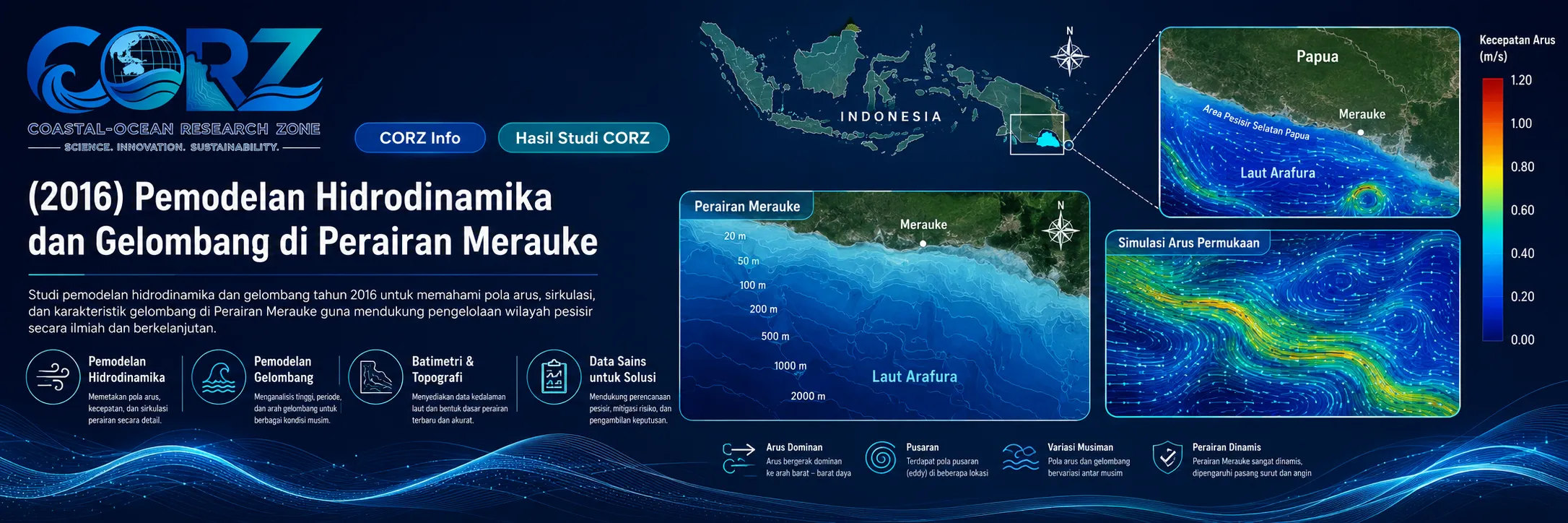
In 2016, CORZ Indonesia conducted Research & Studies involving integrated hydrodynamic and wave modelling in Merauke waters to support coastal spatial planning.
Four principal components were modelled: West Monsoon waves, East Monsoon waves, West Monsoon current circulation, and East Monsoon current circulation.
Together, they form an integrated framework:
WAVES × CURRENTS × SEASON × COASTAL SPACE
Merauke: A Coastal Region of Increasing Strategic Importance
The timing of the study coincided with significant maritime development in Merauke.
In February 2016, local port management identified prolonged tidal conditions as one of the constraints affecting large vessels entering and leaving Merauke Port. The same period included plans to extend the port by 75 × 30 metres and undertake reclamation for a passenger terminal.
Merauke was also incorporated into Indonesia's expanding Sea Toll programme. detikFinance reported in February 2016 that a scheduled route would connect Tanjung Perak with Saumlaki, Dobo, and Merauke.
detikFinance — Merauke included in a new Indonesian Sea Toll route in 2016
Development of the Merauke Oceanic Fishing Port further highlighted the strategic role of the coastal zone. President Joko Widodo inspected the project shortly before 2016, while ANTARA later reported that the facility had been completed during 2016.
These reports were not about the CORZ study.
Their relevance is contextual: as ports, fisheries, transportation, and coastal infrastructure expand, understanding the physical behaviour of the surrounding marine environment becomes increasingly important.
- West Monsoon Wave Modelling
The first study component represented wave conditions during the West Monsoon.
Waves are one of the principal mechanisms by which energy is transported toward the coast.
Conceptually:
WIND → WAVE GENERATION → PROPAGATION → TRANSFORMATION → COASTAL EXPOSURE
Numerical modelling transforms wave conditions from isolated observations into a spatial wave field.
The resulting model provides a framework for examining relative wave exposure, propagation patterns, changes associated with shallow water, and differences between more exposed and sheltered coastal areas.
Such information is relevant to ports, navigation, fisheries, aquaculture, coastal infrastructure, and environmentally sensitive areas.
- East Monsoon Wave Modelling
The same coastal system was then modelled under East Monsoon conditions.
This seasonal comparison is fundamental.
The coastline does not move.
The atmospheric and oceanographic forcing does.
Therefore:
SAME COASTLINE + DIFFERENT MONSOON = DIFFERENT WAVE ENVIRONMENT
An area that appears relatively sheltered under one seasonal regime may not necessarily exhibit the same wave characteristics during another.
Including both monsoon conditions provides a more complete basis for coastal planning than relying on a single representative season.
- West Monsoon Current-Circulation Modelling
Waves describe the movement of energy.
Currents describe the movement of water masses.
The third component of the study modelled current circulation during the West Monsoon.
Each current vector contains:
DIRECTION + VELOCITY + LOCATION + TIME
Together, these vectors reveal how different marine areas are physically connected.
This information is highly relevant to coastal spatial planning because current circulation influences navigation, sediment transport, suspended material, potential pollutant pathways, aquaculture, marine intakes and outfalls, port environments, and water-mass connectivity.
A coastal location therefore cannot always be evaluated as an isolated point.
Hydrodynamic modelling helps reveal the larger system to which it belongs.
- East Monsoon Current-Circulation Modelling
The current model was then evaluated under East Monsoon conditions.
The comparison becomes:
WEST MONSOON CURRENT SYSTEM
versus:
EAST MONSOON CURRENT SYSTEM
This is particularly important for spatial planning because the geographical location remains fixed while the marine transport pathways may change seasonally.
A site suitable for a particular activity under one set of current conditions may interact differently with surrounding waters during another season.
Seasonality is therefore not an optional detail.
It is part of the physical identity of the coastal space.
Four Models, One More Complete Marine Picture
The strength of the CORZ study lies in combining all four simulations.
West Monsoon waves characterise one seasonal energy environment.
East Monsoon waves show how that environment can change.
West Monsoon currents describe water-mass connectivity during one circulation regime.
East Monsoon currents reveal the alternative seasonal pathway.
Together:
WAVE — WEST MONSOON
WAVE — EAST MONSOON
CURRENT — WEST MONSOON
CURRENT — EAST MONSOON
provide information across four key dimensions:
ENERGY × TRANSPORT × SEASONALITY × SPACE
This is what transforms oceanographic modelling into useful coastal spatial intelligence.
From an Oceanographic Map to Coastal Spatial Intelligence
An administrative map tells planners:
“Where is the area?”
Ocean modelling adds another question:
“How does that area function?”
A site may appear geographically attractive for aquaculture, yet experience excessive wave exposure during a particular season.
Another area may appear suitable for an outfall or coastal facility, yet be hydrodynamically connected to environmentally sensitive waters.
A port location may offer strategic connectivity while still facing operational constraints associated with tides, waves, or sediment processes.
A stronger planning framework therefore integrates:
GIS / SPATIAL PLANNING + OCEANOGRAPHY + NUMERICAL MODELLING
The question is not simply:
where is the space?
It becomes:
what happens within that space?
Real Marine Conditions Demonstrate Why This Matters
The importance of understanding physical marine conditions was visible in Merauke itself during 2016.
Local port officials identified tides as an operational limitation for large vessels.
In August that year, ANTARA reported the rescue of eight crew members after a vessel sank in Merauke waters; a crew member described high waves during the incident.
ANTARA — Crew rescued after vessel sank in Merauke waters, August 2016
These incidents were not connected to the CORZ study and should not be interpreted as model validation.
They nevertheless illustrate the broader principle: physical ocean conditions directly influence how coastal waters can be used and managed.
From Modelling to Coastal-Planning Decision Support
An integrated study of this type can support marine and coastal spatial planning, port development, navigation, fisheries, aquaculture, conservation, coastal tourism, shoreline infrastructure, intake and outfall planning, marine-pollution risk assessment, and other strategic coastal uses.
The analytical pathway can be expressed as:
OCEANOGRAPHIC DATA
↓
HYDRODYNAMIC MODEL + WAVE MODEL
↓
WEST & EAST MONSOON SCENARIOS
↓
WAVE EXPOSURE + CURRENT CONNECTIVITY
↓
SPATIAL CHARACTERISATION
↓
COASTAL SUITABILITY INFORMATION
↓
BETTER COASTAL PLANNING
The model does not make the spatial-planning decision by itself.
It provides scientific evidence that can make the decision better informed.
Don't Just Draw the Coastal Zone. Understand the Ocean Inside It.
A line on a map can define a zone.
But the ocean determines how that zone physically functions.
The 2016 Merauke study reflects the CORZ Indonesia Research & Studies approach:
Model the Waves.
Map the Currents.
Compare the Seasons.
Understand the Connectivity.
Characterise the Coastal Space.
Support Better Planning.
Because effective coastal planning should not ask only:
“Where should we develop?”
It should also ask:
“How does the ocean behave there throughout the year?”
CORZ Indonesia for Research & Studies
Hydrodynamic Modelling • Spectral Wave Modelling • Coastal Spatial Planning • Marine Spatial Analysis • Seasonal Ocean Assessment • Coastal & Ocean Management
Coastal-Ocean Research Zone (CORZ) Indonesia provides research, modelling, analysis, and technical solutions for coastal and ocean environments.
YouTube: https://www.youtube.com/@CORZIndonesia
Website: https://corz.co.id
Email: info@corz.co.id
© 2026 CORZ Indonesia. All Rights Reserved.


