
CORZ Indonesia | Research & Studies
From a Local Dredging Site to an Entire River System
Check out some other model outputs on YouTube @CORZIndonesia
Dredging is an essential activity for maintaining the function of anchorage basins, navigation channels, and other marine and river infrastructure.
Yet dredging does more than remove material from the bed.
When bottom sediment is disturbed, part of that material may become resuspended within the water column. Once released, currents begin to transport it away from the work site.
The resulting material may develop into a suspended-sediment plume, become diluted, disperse through connected waterways, and eventually settle again elsewhere.
The important question therefore extends far beyond:
“How much sediment needs to be dredged?”
Environmental assessment must also ask:
Where will the released sediment travel?
How will the plume develop around the dredging site?
Will its influence remain local or extend along the river system?
Where could suspended-sediment concentrations increase?
And how will the plume evolve through time?
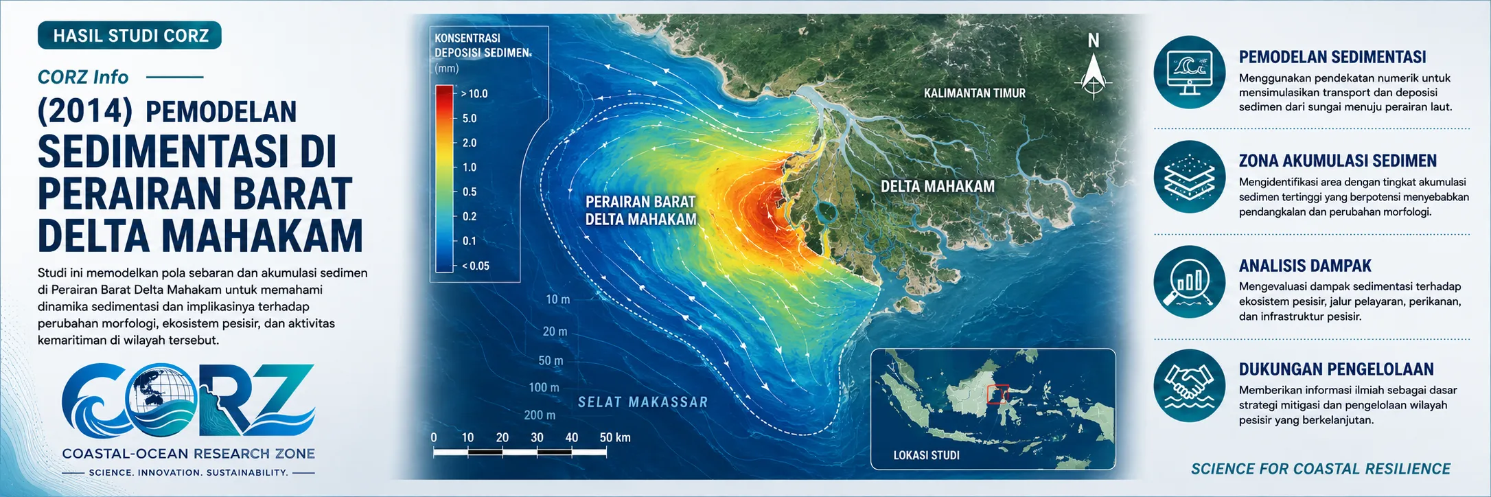
In 2014, CORZ Indonesia conducted Research & Studies involving sediment-dispersion modelling associated with maintenance dredging of an anchorage basin in the waters west of the Mahakam Delta, East Kalimantan.
The study was undertaken at two complementary spatial scales:
- Detailed sediment-dispersion modelling around the dredging area
• Sediment-dispersion modelling throughout the broader river channel system
The two-scale framework provides an important advantage:
understanding local effects without losing the system-wide perspective.
Mahakam Delta: A Sediment System in Continuous Motion
The Mahakam Delta has been created by sediment transport over long periods of time.
River flow carries water and sediment toward the delta, where a complex network of distributary channels interacts with tides and the coastal waters of the Makassar Strait.
Satellite imagery clearly illustrates the intricate network of waterways and sediment-rich flows that characterise the delta.
In such an environment:
sediment is not merely bottom material—it is part of the process that continually shapes the landscape.
This natural dynamism makes sedimentation highly relevant to:
navigation • anchorage areas • oil-and-gas infrastructure • river facilities • shipping • delta ecosystems
During 2014, the Mahakam region also remained strategically important to Indonesia's energy sector, with ANTARA reporting continuing national debate over the future operation of the Mahakam oil and gas block.
ANTARA — Mahakam Block development remained a major national issue in 2014
This reporting was not about the CORZ study, but it illustrates the broader operational significance of the Mahakam environment during the same period.
Why Do Anchorage Basins Require Maintenance?
An anchorage or harbour basin must maintain sufficient water depth for vessels to operate safely.
Within river and delta environments, naturally transported sediment may progressively accumulate on the bed.
Over time:
SEDIMENT TRANSPORT
↓
DEPOSITION
↓
SHOALING
↓
REDUCED WATER DEPTH
Maintenance dredging may then be required to restore operational depth.
The long-term relevance of this problem has also been reflected in mainstream reporting. ANTARA later reported that sections of the Mahakam River had become shallower and that insufficient depth near the river mouth could restrict larger vessels.
ANTARA — Shoaling and river-management challenges in the Mahakam system
This demonstrates why sedimentation studies have direct operational value.
CORZ Research: From Dredging to a Sediment Plume
When dredging equipment disturbs the bed, part of the sediment may become suspended.
Conceptually:
MAINTENANCE DREDGING
↓
BED SEDIMENT DISTURBANCE
↓
SEDIMENT RELEASE
↓
SUSPENDED SEDIMENT PLUME
↓
HYDRODYNAMIC TRANSPORT
↓
DISPERSION & DILUTION
↓
SETTLING / RE-DEPOSITION
The CORZ modelling approach couples the dredging-generated sediment source with the hydrodynamic environment.
The model therefore follows what happens after the sediment enters the water column.
- Detailed Modelling: What Happens Close to the Dredging Site?
The first component involved:
Detailed Sediment-Dispersion Modelling around the Anchorage Basin
A detailed modelling scale provides greater insight into the area closest to dredging operations.
The model can be used to investigate:
- plume development around the dredger;
- principal sediment-transport directions;
- changes in concentration with distance;
- influence of currents on plume geometry;
- surrounding waters receiving suspended material; and
- potential re-deposition after transport.
This scale addresses the question:
“What happens close to the operation?”
Such information is particularly valuable for designing local environmental monitoring and operational controls.
- River-Wide Modelling: Understanding the Larger System
The second component extends the modelling domain.
Sediment does not recognise the administrative boundaries of an anchorage basin.
If hydrodynamic conditions allow, material released locally can become part of a wider transport pathway.
CORZ therefore also conducted:
Sediment-Dispersion Modelling across the Wider River Channel
This scale asks:
“What happens beyond the immediate dredging area?”
The model places the plume within the broader connection:
UPSTREAM ↔ DREDGING AREA ↔ DOWNSTREAM / DELTA CHANNELS
This provides information on hydrodynamic connectivity.
The question is therefore no longer simply:
Where does the work occur?
It becomes:
Which parts of the aquatic system are physically connected to that work through water movement?
Detailed Model + Full-Domain Model
The two modelling scales provide different information.
DETAIL MODEL
asks:
What happens near the source?
while the:
FULL-DOMAIN MODEL
asks:
How could the influence develop within the wider river system?
Combined:
LOCAL DETAIL
+
SYSTEM-WIDE TRANSPORT
=
MORE COMPLETE ENVIRONMENTAL UNDERSTANDING
This is one of the important strengths of the study.
The source and the receiving waters are analysed as components of one connected physical system.
From Dredging Volume to Environmental Footprint
Dredging volume is an essential engineering parameter.
From an environmental perspective, however, it does not tell the whole story.
Additional questions include:
What fraction becomes suspended?
How long does it remain in the water column?
Where does it travel?
How rapidly does it dilute?
Where does it settle again?
The analytical pathway therefore becomes:
DREDGING VOLUME
↓
SEDIMENT RELEASE
↓
SEDIMENT PLUME
↓
POTENTIAL ENVIRONMENTAL FOOTPRINT
Numerical modelling provides the bridge between these stages.
A Sediment Map Is More Than a Colour Map
Sediment-model outputs are often presented as coloured concentration maps.
Yet every model cell represents:
WHERE × WHEN × HOW MUCH
Viewed through time, the simulation can show the plume:
emerging → developing → moving → weakening → settling.
The results can support assessment of:
- potential increases in TSS;
- plume transport distance;
- principal transport pathways;
- plume persistence;
- relationships with currents or tidal conditions;
- potential deposition areas; and
- locations requiring priority monitoring.
A local dredging activity therefore becomes a systematic sediment-transport problem that can be analysed quantitatively.
From Modelling to Better Monitoring
One highly practical benefit of sediment modelling is its ability to support monitoring design.
Without modelling, monitoring stations may be selected primarily according to distance from the dredging site.
With modelling, they can be positioned according to:
predicted plume pathways.
The workflow becomes:
DREDGING LOCATION
↓
MODELLED PLUME
↓
POTENTIAL EXPOSURE AREA
↓
MONITORING STATIONS
↓
FIELD VALIDATION
This enables monitoring to become more targeted, efficient, and scientifically informed.
Local Activity, System-Wide Response
The 2014 study carries an important message.
The engineering activity may be local.
The receiving environment is a system.
The dredger works locally.
The river responds systemically.
That is why CORZ applied two perspectives:
ZOOM IN
to understand the dredging area in detail,
and:
ZOOM OUT
to understand how the broader river system may respond.
This framework is relevant to:
maintenance dredging • capital dredging • anchorage-basin maintenance • navigation channels • pipeline works • river engineering • reclamation
From Dredging to Decision Support
At CORZ Indonesia, the final objective of sediment modelling is not simply to produce an animated plume.
Its purpose is to generate information that supports better decisions.
A study such as the 2014 Mahakam modelling can contribute to:
- Dredging Environmental Assessment
• Anchorage Basin Maintenance
• Navigation-Channel Studies
• Sediment Transport Modelling
• TSS & Turbidity Assessment
• Environmental Impact Assessment (EIA/AMDAL)
• Sediment Monitoring Design
• Port & River Environmental Management
• Dredging Mitigation Planning
The practical questions become:
When should dredging be undertaken?
Where could the plume develop?
Where should monitoring stations be located?
Should the working method be modified?
How can sediment release be minimised?
Which areas require greater protection?
This is where:
SIMULATION → INFORMATION → DECISION.
Model the Plume—Not Just the Dredging.
Dredging occurs at a specific location.
The sediment released from it may travel well beyond that location.
The 2014 western Mahakam Delta study reflects the CORZ Indonesia approach:
Understand the Current.
Define the Dredging Source.
Model the Local Plume.
Track the River-Wide Dispersion.
Design Better Monitoring.
Support Better Environmental Decisions.
Because responsible dredging should not ask only:
“How much should we dredge?”
It must also ask:
“Where will the released sediment go?”
CORZ Indonesia for Research & Studies
Sediment Transport Modelling • Dredging Studies • Anchorage Basin Maintenance • Hydrodynamic Modelling • TSS Assessment • Port & River Environmental Management
Coastal-Ocean Research Zone (CORZ) Indonesia provides research, modelling, analysis, and technical solutions for coastal and ocean environments.
YouTube: https://www.youtube.com/@CORZIndonesia
Website: https://corz.co.id
Email: info@corz.co.id
© 2026 CORZ Indonesia. All Rights Reserved.


