
CORZ Indonesia | Research & Studies
When Natural Waves Meet Vessel-Generated Waves
Check out some other model outputs on YouTube @CORZIndonesia
Waves in marine and delta environments are not generated exclusively by natural processes.
Wind is one of the principal sources of ocean-wave energy. Atmospheric energy is transferred to the water surface, generating waves that propagate and transform as they encounter different depths, shorelines, and coastal configurations.
In waterways also used for transportation and industrial operations, however, another source of wave energy exists:
moving vessels.
Every vessel displaces water as it travels. The interaction among hull geometry, vessel speed, displacement, water depth, and the free surface creates vessel-generated waves, commonly referred to as a ship wake or boat wake.
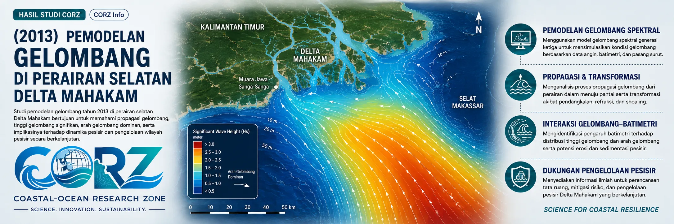
In 2013, CORZ Indonesia conducted Research & Studies involving wave modelling in the waters south of the Mahakam Delta, East Kalimantan, based on three principal scenarios:
- Significant Wind-Generated Wave Modelling
• Sea Truck-Generated Wave Modelling at 16 knots
• Sea Truck-Generated Wave Modelling at 20 knots
The study therefore examined two distinct sources of wave energy:
NATURAL WAVE FORCING × VESSEL-GENERATED WAVE FORCING
allowing the aquatic environment to be understood not only through what nature does to the water, but also through the additional energy introduced by human activity.
South of the Mahakam Delta: Where a Delta Environment Meets Offshore Energy Operations
The Mahakam Delta is a complex coastal system comprising distributary channels, tidal waterways, mangrove environments, estuarine waters, and an offshore system connected with the Makassar Strait.
It is also part of one of Indonesia's most important oil-and-gas regions.
In 2013, The Jakarta Post reported that Indonesia's new gas-development programme included enhanced development of the South Mahakam field in East Kalimantan, with expected production of approximately 202 MMSCFD for delivery to the Bontang LNG system.
The Jakarta Post — New Indonesian gas projects including South Mahakam, 2013
ANTARA also reported in May 2013 on the extensive network of businesses and service providers supporting oil-and-gas operations in the Mahakam Block within the Mahakam River Delta.
ANTARA — Oil-and-gas operations and supporting businesses in the Mahakam Delta, May 2013
These reports were not reports about the CORZ study, nor do they establish a direct connection with the particular Sea Truck represented in the modelling.
They provide historical context showing that Mahakam waters were simultaneously an environmental system and an intensively used operational marine environment.
Two Wave Worlds in a Single Study
The CORZ modelling separates two fundamentally different wave-generation mechanisms.
NATURAL FORCING
WIND
↓
ENERGY TRANSFER
↓
WAVE GENERATION
↓
WAVE PROPAGATION
↓
WAVE TRANSFORMATION
and:
VESSEL FORCING
SEA TRUCK
↓
HULL–WATER INTERACTION
↓
VESSEL WAKE
↓
WAVE PROPAGATION
↓
INTERACTION WITH SURROUNDING WATERS
Both mechanisms create waves.
Their forcing, duration, propagation characteristics, and energy distributions, however, may differ considerably.
Numerical modelling makes it possible to:
separate the source → simulate the response → compare the outcomes.
- Significant Wind-Generated Waves
The first component involved significant wind-generated wave modelling.
In oceanography and coastal engineering, Significant Wave Height (Hs) is a key parameter used to characterise the wave environment.
Numerical modelling transforms wind forcing into spatial wave information that can describe:
- significant-wave-height distribution;
- wave propagation direction;
- spatial differences in wave conditions;
- transformation associated with changing water depth;
- effects of shoreline and delta geometry; and
- relative differences in wave-energy conditions.
Conceptually:
WIND
↓
ENERGY TRANSFER
↓
WAVE GENERATION
↓
PROPAGATION
↓
TRANSFORMATION
↓
DELTA / COASTAL WATERS
Rather than providing only a wave height at one monitoring point, the simulation generates a:
WAVE FIELD IN SPACE AND TIME.
- Sea Truck-Generated Waves at 16 Knots
The second scenario represented a Sea Truck travelling at 16 knots.
As the vessel moves, its hull displaces water and disturbs the free surface.
The resulting energy generates a wake that propagates away from the navigation track.
Conceptually:
SEA TRUCK @ 16 KNOTS
↓
WATER DISPLACEMENT
↓
VESSEL-GENERATED WAVE
↓
PROPAGATION
↓
WAVE TRANSFORMATION
↓
RECEIVING WATERS
The model allows that evolving wake system to be examined across space and time.
The key question therefore changes from:
“Where does the vessel travel?”
to:
“Where does the wave energy travel after the vessel passes?”
- Sea Truck-Generated Waves at 20 Knots
The third scenario increased vessel operating speed to:
20 KNOTS.
Why model two speeds?
Because vessel speed is one of the parameters capable of changing wake characteristics.
Comparing:
16 KNOTS
with:
20 KNOTS
allows the hydrodynamic response to two operational conditions to be assessed.
It is important, however, not to reduce the relationship to the simplistic assumption:
a 20-knot vessel must always generate a higher wave than the same vessel at 16 knots.
Wake behaviour also depends on:
hull geometry • vessel length • displacement • loading condition • water depth • draft • distance from the vessel track • speed-to-length relationship
Different hydrodynamic regimes may also alter the resulting wake characteristics.
This is precisely why modelling matters:
SIMULATE FIRST. CONCLUDE FROM THE RESULTS.
16 Knots vs 20 Knots: Turning an Operational Choice into a Scientific Scenario
The two speeds allow a practical operating question to become a modelling experiment:
“What changes when vessel speed changes?”
Conceptually:
SAME VESSEL
SAME WATERBODY
DIFFERENT SPEED
↓
DIFFERENT HYDRODYNAMIC RESPONSE?
The simulations provide a framework for comparing:
- wave height;
- spatial wave distribution;
- wake propagation patterns;
- areas receiving vessel-generated wave energy;
- changes with distance from the navigation track; and
- responses of shallow water or nearby shorelines.
This is scenario-based modelling.
It allows operational alternatives to be evaluated before decisions are implemented.
Why Vessel-Generated Waves Matter in a Delta
In the open sea, an individual vessel wake may represent only a small component of the overall wave climate.
In relatively sheltered delta channels or coastal waterways, the context can be different.
Vessel-generated waves may reach:
channel banks • mangrove margins • muddy shorelines • marine structures • operational facilities • sedimentary environments
and repeated vessel passages mean repeated energy input.
Wake modelling can therefore provide valuable information for further assessment of:
shoreline and bank erosion
sediment resuspension
mangrove-edge stability
navigational operations
infrastructure protection
environmental management
Mangrove Protection: Why Wave Energy at the Water's Edge Matters
Environmental protection within the Mahakam Delta was receiving significant attention during the same period.
On 2 February 2013, ANTARA reported the planting of 10,000 mangrove seedlings in the Mahakam Delta at Teluk Pemedas, Samboja, as part of East Kalimantan's environmental-restoration programme.
ANTARA — Mangrove planting in the Mahakam Delta, February 2013
That programme was not connected to the CORZ wave-modelling study.
Its relevance is contextual.
The Mahakam Delta is not only working water supporting industrial and transportation activities.
It is also a living ecosystem.
Understanding how wave energy interacts with the water's edge can therefore have value extending beyond vessel operations alone.
Natural Waves vs Vessel Wake
One of the most useful conceptual outcomes of this study is the ability to compare:
What does nature generate?
with:
What does vessel operation add?
The modelling framework contains:
SCENARIO 01
Wind-Generated Significant Waves
SCENARIO 02
Sea Truck — 16 knots
SCENARIO 03
Sea Truck — 20 knots
Together, these scenarios contribute to understanding both:
THE NATURAL WAVE ENVIRONMENT
and:
THE VESSEL-GENERATED WAVE ENVIRONMENT.
The two should not simply be numerically added without appropriate wave analysis.
The important point is that both need to be understood when evaluating a heavily used aquatic environment.
From Wave Maps to Operational Decision Support
At CORZ Indonesia, a wave model is more than a coloured map of wave heights.
Its real value lies in the questions the simulation can help answer:
What is the natural wave environment?
How does a Sea Truck modify the local wave field?
How does the response differ between 16 and 20 knots?
Which areas receive stronger vessel-generated wave influence?
Should vessel distance from sensitive shorelines be evaluated?
Could operating speed form part of an environmental mitigation strategy?
Where could additional field monitoring be useful?
This is where:
WAVE MODELLING
becomes:
OPERATIONAL & ENVIRONMENTAL DECISION SUPPORT.
Speed Is an Operational Parameter—and an Environmental Variable.
Vessel speed is normally viewed as an operational consideration:
How quickly can the vessel reach its destination?
Within certain aquatic environments, however, speed is also an environmental variable.
Changing vessel speed can change the interaction:
VESSEL × WATER × WAVE × SHORELINE
This is one of the key messages of the 2013 CORZ study.
Numerical modelling allows an operational decision to be examined not only from the perspective of vessel efficiency, but also through the hydrodynamic response of the surrounding environment.
From Wind to Wake. From Simulation to Better Operations.
The 2013 study south of the Mahakam Delta demonstrates that understanding waves requires more than examining the weather.
Some waves are generated by nature.
Others are generated by our own activities.
CORZ Indonesia connects the two through:
Understand the Wind.
Model the Natural Waves.
Simulate the Vessel Wake.
Compare the Speeds.
Trace the Energy.
Support Safer and Smarter Operations.
Because the most important question is not simply:
“How high is the wave?”
It is:
“What created it, where will it travel, and what will it interact with?”
CORZ Indonesia for Research & Studies
Spectral Wave Modelling • Wind-Wave Modelling • Vessel-Generated Wave Modelling • Sea Truck Wake Assessment • Navigation & Operational Studies • Coastal & Environmental Engineering
Coastal-Ocean Research Zone (CORZ) Indonesia provides research, modelling, analysis, and technical solutions for coastal and ocean environments.
YouTube: https://www.youtube.com/@CORZIndonesia
Website: https://corz.co.id
Email: info@corz.co.id
© 2026 CORZ Indonesia. All Rights Reserved.


