
CORZ Indonesia | Research & Studies
When Waves Are Generated by More Than Wind
Check out some other model outputs on YouTube @CORZIndonesia
Ocean waves are commonly associated with wind.
Wind transfers energy to the water surface, generating waves that propagate, transform, and interact with shallow waters and coastlines.
In rivers, estuaries, deltas, ports, and active waterways, however, wind is not the only source of waves.
Moving vessels generate waves as well.
When a speed boat travels through the water, interactions between its hull and the surrounding water generate vessel-generated waves, or boat wakes. These waves propagate away from the vessel track and may interact with channel banks, shorelines, coastal structures, sediments, and nearby aquatic environments.
The scientific questions therefore extend beyond:
“How high are the wind-generated waves?”
They also include:
What wave characteristics are generated by a moving vessel?
How does the response change with vessel speed?
How does the wake propagate away from the navigation track?
And how do natural and human-generated wave sources contribute to the wave environment of the Mahakam Delta?
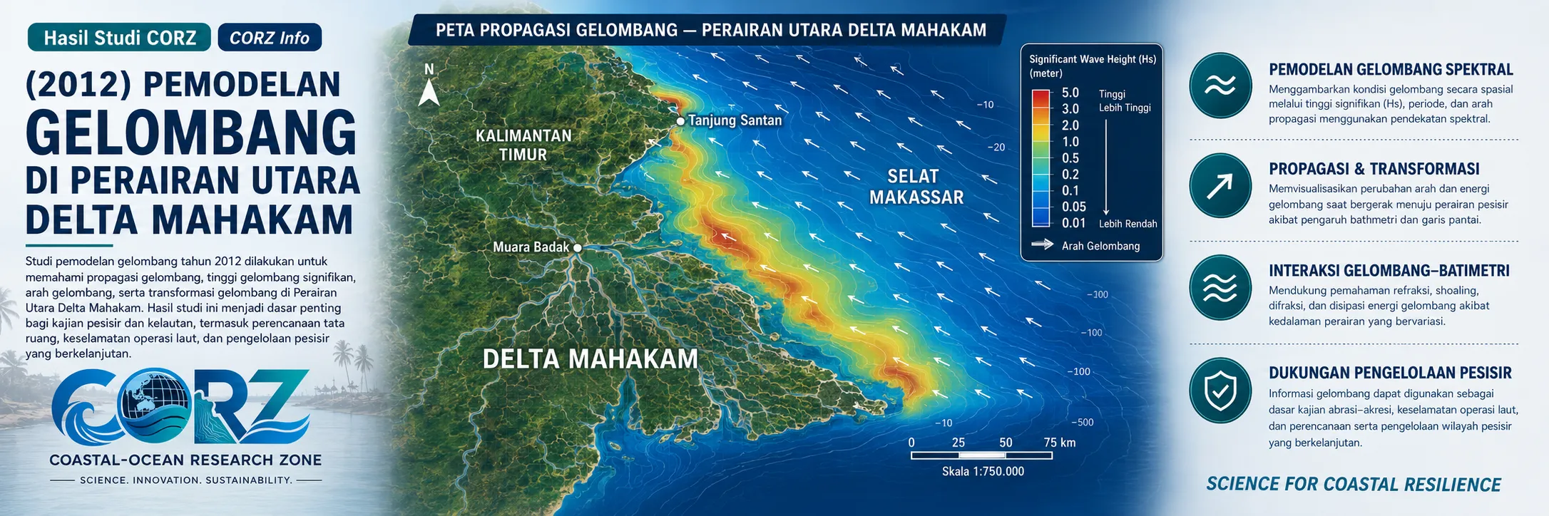
In 2012, CORZ Indonesia conducted Research & Studies involving wave modelling in the waters north of the Mahakam Delta, East Kalimantan, based on three primary scenarios:
- Significant Wind-Generated Wave Modelling
• Speed-Boat-Generated Wave Modelling at 16 knots
• Speed-Boat-Generated Wave Modelling at 20 knots
The study therefore investigated the marine environment from two complementary perspectives:
NATURAL WAVES × VESSEL-GENERATED WAVES
providing a framework for understanding both natural wave forcing and the additional wave energy introduced by vessel operations.
Mahakam Delta: A Dynamic Aquatic System
The Mahakam Delta is one of East Kalimantan's important coastal landscapes.
In September 2012, ANTARA described the delta as an estuarine environment covering approximately 1,500 km², comprising numerous islands and waterways formed by Mahakam River sediment entering the Makassar Strait. The report also highlighted its mangrove ecosystems, biological resources, and major oil-and-gas activities.
ANTARA — Pundi-Pundi Alam Delta Mahakam, 30 September 2012
Such an environment is far from static.
Rivers transport sediment.
Tides move water masses.
Wind generates waves.
Vessels introduce additional energy into the water.
Understanding the combined physical environment therefore requires more than observing a single process in isolation.
CORZ Research: Separating Two Sources of Wave Energy
One of the distinctive features of the 2012 CORZ study was its separation of naturally wind-generated waves from waves generated by vessel movement.
Both are waves.
Their generating mechanisms, however, are fundamentally different.
WIND-GENERATED WAVES
Wind → energy transfer → water surface → wave spectrum
VESSEL-GENERATED WAVES
Vessel motion → hull-water interaction → boat wake → wave propagation
Because the forcing mechanisms differ, their characteristics should also be evaluated independently.
The modelling therefore moves beyond simply stating:
“There are waves.”
It asks:
“What generated those waves, what are their characteristics, and how do they behave?”
- Significant Wind-Generated Wave Modelling
The first component of the CORZ study involved significant wind-wave modelling in the waters north of the Mahakam Delta.
In marine wave studies, significant wave height (Hs) is an important parameter used to characterise a wave field.
Numerical modelling can transform wind forcing into spatial wave information that supports analysis of:
- significant-wave-height distribution;
- wave propagation direction;
- variation between more exposed and sheltered waters;
- transformation associated with water depth and coastal configuration; and
- spatial differences in wave-energy conditions.
Conceptually:
WIND
↓
ENERGY TRANSFER
↓
WAVE GENERATION
↓
PROPAGATION
↓
WAVE TRANSFORMATION
↓
COASTAL / DELTA WATERS
The result is not merely a measurement at one location but a spatial representation of the wave field across the modelling domain.
- Speed-Boat-Generated Waves at 16 Knots
The second scenario introduced a completely different wave source.
CORZ modelled waves generated by a speed boat travelling at 16 knots.
A moving vessel displaces water and creates a wave system that propagates away from its track.
This process produces:
VESSEL-GENERATED WAVES / BOAT WAKE.
Numerical modelling provides a framework for examining how those waves:
are generated → propagate → spread → transform → interact with surrounding waters.
This type of information becomes particularly relevant in waterways where vessel traffic operates close to channel banks, delta shorelines, infrastructure, or environmentally sensitive areas.
- Speed-Boat-Generated Waves at 20 Knots
The third scenario represented the same class of vessel travelling at:
20 KNOTS.
The use of two vessel speeds creates a valuable scenario-comparison framework.
The model allows:
16 KNOTS
to be compared with:
20 KNOTS
to assess how changes in vessel operation may alter the resulting wave field.
Importantly, the relationship between vessel speed and wave height should not be reduced to the assumption:
“A faster boat always produces a higher wave.”
Actual wake characteristics may depend on hull geometry, vessel displacement, planing regime, water depth, distance from the sailing line, and environmental conditions.
This is precisely why modelling is valuable:
do not assume the response—simulate it.
Three Scenarios, Two Fundamental Questions
The overall study can be summarised as:
NATURAL WAVES
01 — Wind-Generated Significant Waves
VESSEL-GENERATED WAVES
02 — Speed Boat | 16 knots
03 — Speed Boat | 20 knots
Together, the simulations address two broad questions.
FIRST — What is the natural wave environment?
→ Wind-wave modelling
SECOND — What additional wave response may be generated by vessels?
→ Vessel-generated wave modelling
The combined perspective becomes:
NATURAL FORCING + HUMAN-INDUCED FORCING = A MORE COMPLETE WAVE ENVIRONMENT
Why Do Vessel-Generated Waves Matter?
Vessel wakes are sometimes considered minor compared with waves in the open ocean.
Location, however, matters.
In rivers, channels, estuaries, deltas, marinas, and sheltered waterways, vessel-generated waves can create repeated energy inputs close to shore.
Relevant questions include:
Does the vessel wake reach the shoreline?
How much wave energy is transmitted?
How does the response change with water depth?
Does changing vessel speed alter wave conditions in critical areas?
Are environmentally sensitive shorelines repeatedly exposed?
Because waves interact with sediment, repeated wave forcing may also be relevant to further studies of bank erosion, shoreline stability, sediment resuspension, and protection of coastal vegetation.
Vessel Activity Was Already Part of the Mahakam System in 2012
Vessel activity on the Mahakam waterways was not an abstract modelling assumption.
In September 2012, ANTARA reported that the Mahakam Festival included a wide range of water-based activities involving traditional ferry boats, dragon boats, small powered boats, jet skis, water skiing, and powerboats. The report also noted the long-standing role of traditional boats as a mode of transportation on the Mahakam River.
ANTARA — Boat Activities at the 2012 Mahakam Festival
This news report was not about the CORZ study and did not specifically concern the model area north of the Mahakam Delta.
Its relevance is contextual: powered-vessel activity forms a real part of the wider Mahakam aquatic environment.
That makes the study of vessel-generated waves practically relevant where navigation, economic activities, infrastructure, and ecological functions share the same water system.
A Delta Environment Requires More Than Wave Height Alone
Environmental attention to the Mahakam Delta was also significant in 2012.
Research published that year described the delta as a highly dynamic environmental system and examined water quality and ecological pressures associated with human activities.
Wave modelling therefore does not exist in isolation.
Wave energy interacts with a broader system involving:
CURRENTS + TIDES + SEDIMENT + MANGROVES + HUMAN ACTIVITY + INFRASTRUCTURE
Understanding waves is valuable because they can influence several of those components.
From Wave Height to Environmental and Engineering Information
At CORZ Indonesia, a wave-height map is more than a coloured modelling output.
Each model location contains information about:
WHERE + HOW HIGH + FROM WHICH SOURCE + UNDER WHICH SCENARIO
Comparing all three simulations can provide a framework for understanding:
- the natural wave environment;
- vessel-generated wave patterns;
- differences associated with vessel operating speeds;
- locations receiving wave energy;
- potential requirements for vessel-operation assessment;
- areas requiring additional monitoring; and
- links between wave dynamics and environmental or engineering issues.
This is where numerical simulation becomes decision-support information.
More Than Ocean-Wave Modelling
Studies of this type can contribute to:
- Wave Climate Assessment
• Vessel-Generated Wave / Wake Studies
• Navigation & Vessel Operation Assessment
• Coastal & Riverbank Protection
• Shoreline Erosion Studies
• Sediment Resuspension Assessment
• Port & Waterway Planning
• Environmental Impact Assessment (EIA/AMDAL)
• Mangrove & Sensitive-Shoreline Studies
The modelling framework can support operational questions such as:
Should vessel speed be evaluated within particular sections of a waterway?
Is a navigation corridor sufficiently separated from sensitive shorelines?
How does the vessel-generated wave field compare with natural waves?
Would mitigation or additional monitoring be beneficial?
A numerical model does not replace the decision.
It provides information that makes the decision better informed.
From Wind to Wake: Understanding Every Wave That Matters.
Wind generates waves.
Moving vessels generate waves too.
Within a dynamic delta environment, both can become part of the same physical system.
The 2012 Mahakam Delta study reflects the CORZ Indonesia Research & Studies approach:
Understand the Natural Waves.
Model the Vessel Wake.
Compare the Speeds.
Trace the Energy.
Assess the Environment.
Support Better Decisions.
Because responsible waterway management should not ask only:
“How high are the waves?”
It should also ask:
“What generates them—and where does their energy go?”
CORZ Indonesia for Research & Studies
Spectral Wave Modelling • Wind-Wave Modelling • Vessel-Generated Wave Modelling • Boat Wake Assessment • Coastal & River Engineering • Environmental Impact Assessment
Coastal-Ocean Research Zone (CORZ) Indonesia provides research, modelling, analysis, and technical solutions for coastal and ocean environments.
YouTube: https://www.youtube.com/@CORZIndonesia
Website: https://corz.co.id
Email: info@corz.co.id
© 2026 CORZ Indonesia. All Rights Reserved.


