
CORZ Indonesia | Research & Studies
When Seabed and Riverbed Works Mobilise Sediment through an Entire Aquatic System
Check out some other model outputs on YouTube @CORZIndonesia
Dredging may take place within a relatively narrow construction or maintenance corridor.
The sediment released during those operations, however, does not necessarily remain at the work site.
Once sediment particles enter the water column, the currents take over.
Suspended material may be transported away from the source, develop into a sediment plume, become diluted, settle elsewhere, or enter other parts of a connected river-estuary system.
In a complex environment such as the Mahakam Delta, the important questions therefore extend far beyond:
“How much sediment is dredged?”
They become:
What fraction of the material may be released into the water column?
Where could the sediment travel?
How widely could the plume develop?
How might concentrations vary across space and time?
And how does potential environmental influence change as the sediment-release percentage increases?
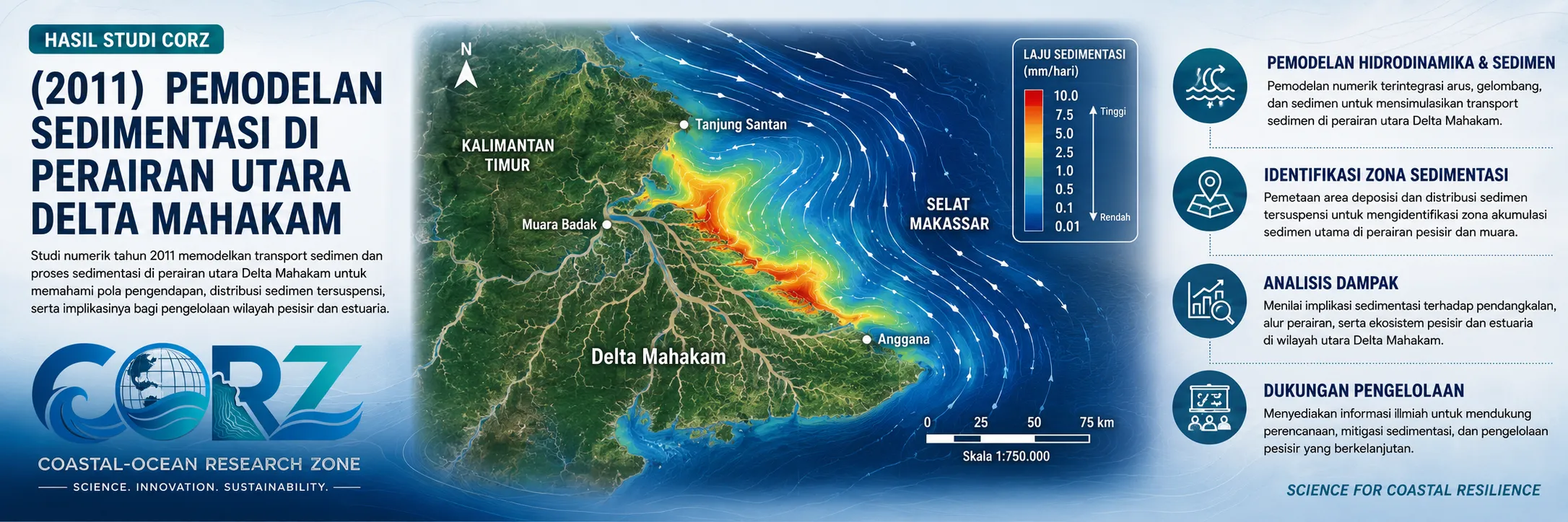
In 2011, CORZ Indonesia conducted Research & Studies involving numerical modelling of sediment dispersion generated by dredging and backfilling activities undertaken to support maintenance of a river-crossing pipeline in the northern Mahakam Delta, East Kalimantan.
Four modelling scenarios were evaluated:
- Worst-Case Scenario
• Sediment Spill Release — 12.5%
• Sediment Spill Release — 14.5%
• Sediment Spill Release — 17.5%
Together, the scenarios provide a framework for examining how changes in sediment-release magnitude can influence the resulting dispersion pattern within the receiving waters.
Mahakam Delta: Where Rivers, Ocean, Sediment, Ecosystems and Infrastructure Meet
The Mahakam Delta is not a simple water body.
It consists of an intricate network of distributary channels, tidal waterways, estuaries, delta plains, mangrove environments and coastal waters connected directly with the Makassar Strait.
Sediment is a fundamental part of the natural system that built the delta.
Marine-geology research has documented the dynamic nature of the outer Mahakam Delta, where sedimentation, erosion and delta progradation can vary significantly across both space and time.
Within this naturally dynamic environment, numerous human activities coexist:
fisheries • river transportation • coastal communities • industry • oil and gas • pipelines • offshore infrastructure
Engineering activities therefore need to address two objectives simultaneously:
maintaining infrastructure reliability
and
protecting the receiving environment.
Numerical modelling provides a bridge between engineering requirements and environmental management.
The 2011 Context: Expanding Energy Infrastructure around Mahakam
The year of the study provides particularly relevant historical context.
On 19 November 2011, ANTARA reported development of the South Mahakam Block in the Makassar Strait. The project involved three offshore platforms and a network of subsea pipelines, including an approximately 67-km pipeline to the Senipah Base. The report also noted that marine notices associated with pipeline installation would affect vessels operating through waters from Balikpapan, Samboja and Senipah to the Mahakam Delta.
ANTARA — Total E&P Indonesie opens new South Mahakam gas field, 19 November 2011
These news reports were not reports about the CORZ study.
They nevertheless demonstrate the intensity of offshore and pipeline development in the Mahakam region during the same period.
Where pipelines intersect active river and delta systems, maintenance activities inevitably become both an engineering issue and an environmental issue.
Why Do River-Crossing Pipelines Require Maintenance?
A pipeline crossing beneath a river exists within a continuously changing environment.
Sedimentation can increase the thickness of material covering the pipeline.
Conversely, erosion and scour can remove protective sediment.
Riverbed morphology can also change due to currents, sediment transport and vessel activity.
Maintenance may therefore require a sequence such as:
DREDGING → PIPELINE MAINTENANCE → BACKFILLING
Dredging provides access to the pipeline corridor.
Following maintenance, sediment may be replaced as part of the backfilling process.
Each stage that disturbs bottom material, however, raises an important environmental question:
How much sediment may escape from the operation and become suspended in the water column?
From Riverbed Sediment to a Suspended-Sediment Plume
Sediment disturbed by dredging can become suspended.
Conceptually:
DREDGING / BACKFILLING
↓
SEDIMENT RELEASE
↓
SUSPENDED SEDIMENT
↓
HYDRODYNAMIC TRANSPORT
↓
ADVECTION & DISPERSION
↓
SETTLING / DEPOSITION
↓
RECEIVING WATERS
This is the process investigated through the CORZ modelling framework.
The sediment source generated by the operation is connected with the hydrodynamic model, allowing the plume to be examined not merely as a concentration at the dredging location but as a phenomenon evolving across:
SPACE × TIME.
Four Scenarios: Testing Environmental Sensitivity to Sediment Release
One of the strongest elements of the 2011 CORZ study is its use of multiple sediment-release scenarios.
Why use several scenarios?
Because actual dredging and backfilling operations involve uncertainty regarding the proportion of bottom sediment that may become suspended.
Instead of relying on a single assumption, the model examines several levels of sediment spill.
- Worst-Case Scenario
The first simulation represents the worst-case condition defined within the study configuration.
This does not mean that the scenario is expected to occur.
Worst-case modelling instead asks:
“If the least favourable sediment-release condition represented in the study occurred, how would the receiving water respond?”
Such a scenario helps assess the upper range of consequences that may need to be considered when planning mitigation and operational controls.
- Sediment Spill Release — 12.5%
The next scenario evaluates a 12.5% sediment-release assumption, according to the operational definition used within the modelling study.
The model then represents the pathway:
resuspension → current transport → dispersion → dilution → settling.
The resulting simulation provides a spatial and temporal representation of the plume for that release condition.
- Sediment Spill Release — 14.5%
The 14.5% scenario represents a higher source input.
It provides an opportunity to assess sensitivity:
Does the plume become wider?
Do concentrations increase?
Does exposure persist for longer?
Which parts of the receiving waters become increasingly important?
Without assuming numerical results that have not been supplied, comparison among scenarios forms the basis of a meaningful sensitivity analysis.
- Sediment Spill Release — 17.5%
The 17.5% scenario represents a further increase in sediment release.
Together, the four simulations form a scenario envelope:
WORST CASE
12.5%
14.5%
17.5%
allowing the relationship:
SOURCE MAGNITUDE → PLUME RESPONSE
to be systematically investigated.
It Is Not Only About How Much Sediment Is Released
Release percentage is only the beginning of the problem.
What matters next is what the hydrodynamic system does with that material.
The same quantity of released sediment may produce very different plume patterns under different:
currents • tidal conditions • locations • water depths • sediment characteristics
CORZ therefore combines the sediment source with hydrodynamic modelling.
The physical principle is:
**SEDIMENT RELEASE
×
CURRENT CIRCULATION
×
SEDIMENT CHARACTERISTICS
×
TIME
SPATIAL DISPERSION**
This is why sediment modelling provides substantially more information than dredging volume alone.
From Concentration Maps to Areas of Potential Influence
Sedimentation-model outputs may be displayed as maps of suspended-sediment concentration.
But the colour patterns represent far more than graphics.
Each model cell carries information about:
WHERE + WHEN + HOW MUCH
When analysed over time, simulations can provide insight into:
- plume direction and development;
- spatial distribution of suspended sediment;
- areas potentially experiencing elevated TSS;
- changes in plume characteristics during operations;
- settling and deposition tendencies; and
- differences among release scenarios.
The analysis therefore transforms:
“Dredging occurs here.”
into:
“What spatial and temporal consequences could result from that dredging operation?”
World Delta Summit 2011: Mahakam in a Wider Environmental Context
In November 2011, Indonesia hosted the World Delta Summit.
ANTARA reported that the meeting would discuss challenges facing river deltas and specifically identified the Mahakam among Indonesia's important delta systems. The summit aimed to build commitments and practical solutions for delta protection.
ANTARA — Indonesia to host World Delta Summit 2011
The historical context highlights two requirements operating simultaneously:
INFRASTRUCTURE DEVELOPMENT
and
DELTA ENVIRONMENTAL MANAGEMENT
The CORZ sediment-modelling study lies directly at that intersection.
Modelling Before Dredging
A traditional engineering question may begin with:
How much material must be dredged?
Environmental assessment adds:
How much may become suspended?
Numerical modelling goes further:
Where could that released material travel?
The decision-support chain therefore becomes:
ENGINEERING DESIGN
↓
DREDGING PLAN
↓
SEDIMENT-RELEASE SCENARIOS
↓
HYDRODYNAMIC & SEDIMENT MODELLING
↓
POTENTIAL AREA OF INFLUENCE
↓
MITIGATION & OPERATIONAL PLANNING
From Modelling to Environmental Decision Support
For CORZ Indonesia, the objective of sediment-plume modelling is not merely to generate colourful simulations.
The real objective is to transform complex sediment dynamics into usable information.
Such modelling can support:
- Dredging Environmental Assessment
• Pipeline Maintenance Studies
• River-Crossing Pipeline Assessment
• Environmental Impact Assessment (EIA/AMDAL)
• TSS & Turbidity Assessment
• Dredging and Backfilling Planning
• River and Marine Environmental Monitoring
• Sediment Management
• Operational Mitigation Planning
The simulations can help decision-makers ask:
Should the dredging method be adjusted?
Can sediment release be reduced?
When should operations be undertaken?
Where should monitoring stations be located?
Which areas require greater environmental attention?
This is where modelling becomes decision support.
Four Scenarios. One Goal: Reduce Environmental Uncertainty.
The 2011 Mahakam Delta study represents an important CORZ Indonesia Research & Studies principle:
do not only quantify what is dredged—understand what happens to what escapes.
Multiple scenarios allow uncertainty to be explored before operational decisions are made.
Understand the Current.
Quantify the Release.
Model the Plume.
Compare the Scenarios.
Reduce the Uncertainty.
Protect the Receiving Waters.
Because responsible engineering should not ask only:
“Can we do it?”
It should also ask:
“How can we do it with a better understanding of the environmental consequences?”
CORZ Indonesia for Research & Studies
Sediment Transport Modelling • Dredging & Backfilling Studies • Hydrodynamic Modelling • Subsea/River-Crossing Pipeline Studies • TSS Assessment • Environmental Impact Assessment
Coastal-Ocean Research Zone (CORZ) Indonesia provides research, modelling, analysis, and technical solutions for coastal and ocean environments.
YouTube: https://www.youtube.com/@CORZIndonesia
Website: https://corz.co.id
Email: info@corz.co.id
© 2026 CORZ Indonesia. All Rights Reserved.


