
CORZ Indonesia | Research & Studies
Understanding the Current to Understand Where Pollution Could Travel
Check out some other model outputs on YouTube @CORZIndonesia
The ocean is never truly stationary.
Beneath its surface, water masses continuously move under the influence of currents, tides, winds, and other oceanographic forces. When a pollutant enters the marine environment, its journey does not end at the source.
The currents begin to take over.
A substance can be transported away from its release point, transferred between different marine areas, diluted, mixed with surrounding water, or eventually reach coastal environments far from where it initially entered the sea.
Before asking:
“What will the pollutant concentration be?”
there is therefore a more fundamental question:
“Where will the water carry it?”
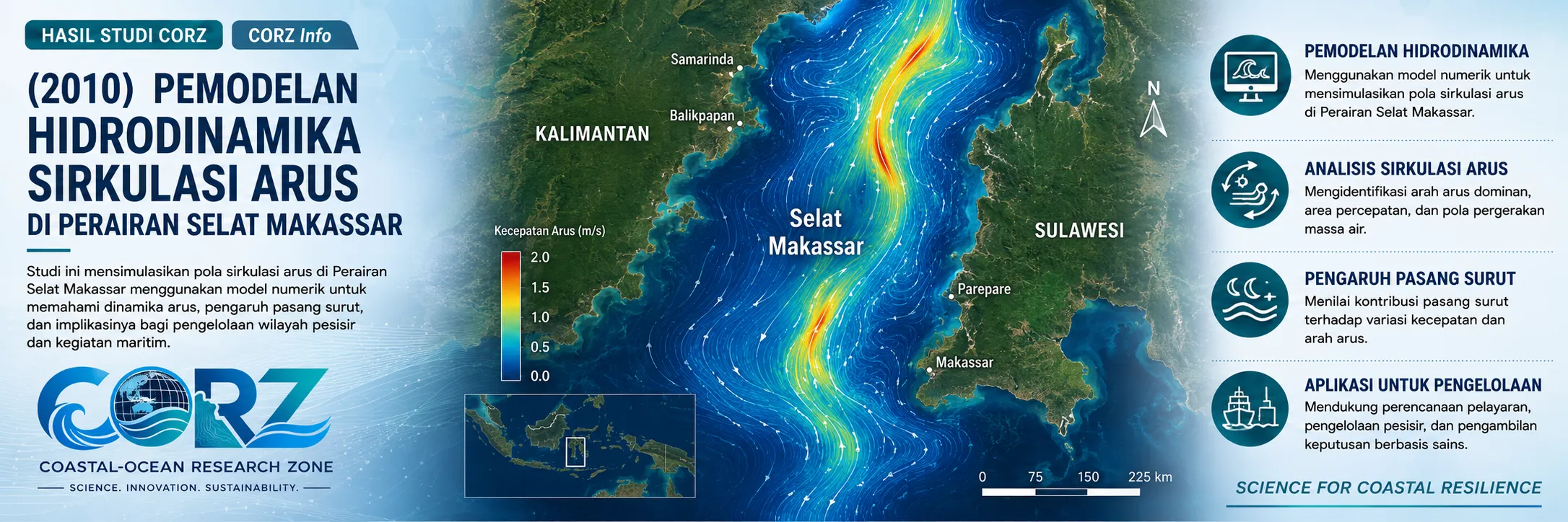
In 2010, CORZ Indonesia conducted Research & Studies involving:
Hydrodynamic Current-Circulation Modelling to Support an Assessment of Potential Pollutant Dispersion in Makassar Waters
The study used numerical modelling to represent current-circulation patterns across space and time, providing a physical foundation for understanding potential pollutant-transport pathways in the marine environment.
In simple terms:
To understand where pollution may travel, we must first understand where the water travels.
Makassar Strait: A Strategic and Dynamic Marine Corridor
The Makassar Strait is one of Indonesia's strategically important marine corridors.
Its waters connect numerous activities and interests:
shipping • ports • coastal industries • oil and gas • fisheries • coastal settlements • marine ecosystems
Makassar's coastal waters also interact directly with rivers, canals, ports, urban areas, and land-based activities capable of delivering materials into the sea.
As human activity increases, so does the importance of understanding how the marine environment transports substances away from their sources.
And during the very year of the CORZ study, a real pollution event demonstrated the relevance of that question.
On 27 July 2010, ANTARA reported that approximately 300 litres of fuel oil/MFO were spilled during bunkering operations involving the tanker MV Marine II in Makassar waters. The report stated that pollution occurred around the Pertamina jetty and had the potential to spread toward the waters of Soekarno-Hatta Port.
ANTARA — 300 Litres of Fuel Spilled in Makassar Waters, 27 July 2010
The incident was not predicted by the CORZ model.
Its relevance is instead conceptual and practical: it demonstrates why understanding currents and potential pollutant-transport pathways matters in Makassar waters.
CORZ Research: Modelling the Ocean's Transport Engine
The CORZ study placed hydrodynamics at the foundation of the assessment.
Why?
Because materials suspended or dissolved in the water column interact with the movement of the surrounding marine environment.
Conceptually:
POLLUTANT SOURCE
↓
HYDRODYNAMIC CIRCULATION
↓
CURRENT DIRECTION & VELOCITY
↓
POTENTIAL TRANSPORT PATHWAY
↓
POTENTIAL DISPERSION AREA
A hydrodynamic model provides information on:
- current direction;
- current-velocity distribution;
- temporal changes in circulation;
- hydrodynamic connections among different parts of the marine domain; and
- pathways through which water masses may transport material.
These outputs can then provide a physical foundation for more detailed advection–dispersion and pollutant-transport modelling.
This distinction is important.
Hydrodynamic modelling alone does not mean that an area will become polluted.
Rather, it helps explain how the marine system moves and which transport pathways may physically develop if a substance is introduced into that system.
Current Vectors: Small Arrows, Powerful Information
One of the most recognisable outputs of a hydrodynamic simulation is the current vector.
On a map, these vectors appear simply as arrows.
Each arrow, however, contains several dimensions of information:
DIRECTION + VELOCITY + LOCATION + TIME
Together, thousands of current vectors produce an evolving representation of how Makassar waters function as a connected physical system.
They help reveal:
where the water comes from → where it travels → how quickly it moves → which marine areas are connected through water-mass transport.
For marine-pollution assessment, those connections matter.
The sea itself can become a transport pathway.
From a Pollution Source to Receiving Waters
Imagine a pollutant source at a single location.
Without hydrodynamic information, we have only a point:
SOURCE ●
But the ocean does not treat that point as isolated.
Once material enters the water:
SOURCE
↓
CURRENT TRANSPORT
↓
ADVECTION
↓
DISPERSION
↓
RECEIVING WATERS
This is why current modelling is an important foundation for pollutant-dispersion assessment.
The key question changes from:
“Where is the source located?”
to:
“Which marine areas are hydrodynamically connected to that source?”
The second question is substantially more valuable when evaluating potential environmental impacts.
Pollution Can Originate from Many Sources
Potential marine pollution is not limited to a single substance or activity.
Sources may include:
- port and vessel operations
• coastal industrial facilities
• marine outfalls
• rivers and urban canals
• petroleum and fuel releases
• suspended material
• nutrients
• certain chemicals
• urban runoff
These sources may have very different characteristics.
Once they enter the sea, however, they share an important factor:
marine dynamics influence what happens next.
Environmental Events Around Makassar Demonstrate the Relevance
Pollution concerns around Makassar did not end with the 2010 fuel-spill incident.
In 2011, ANTARA reported concerns among residents along the Tallo River after several companies were alleged to have discharged liquid waste and hazardous materials. The Tallo River drains toward Makassar's coastal environment, demonstrating how land-based pollution issues can be physically linked to receiving coastal waters.
ANTARA — Residents Concerned About Pollution in the Tallo River
In the wider Makassar Strait, ANTARA reported in 2012 that a fishermen's group in West Sulawesi alleged marine pollution associated with offshore oil-exploration activities. This was an allegation reported by the fishermen, rather than a definitive scientific attribution of pollution, and should therefore be interpreted cautiously. Nevertheless, it illustrates the continuing public concern surrounding offshore activity and environmental quality within the Makassar Strait.
ANTARA — Fishermen Raise Pollution Concerns in the Makassar Strait, 2012
A Decade Later, the Same Challenge Remained Visible
On 20 May 2020, a leak during bunkering of Low Sulfur Fuel Oil caused an oil spill along the Makassar coast.
detikFinance reported that a combined Pertamina response team acted to prevent the oil from spreading over a wider area.
detikFinance — Cause of the Makassar Coastal Oil Spill, 22 May 2020
This incident occurred ten years after the CORZ study and was not directly connected with it.
Yet the underlying physical principle remained unchanged:
when pollution enters the ocean, understanding currents becomes one of the keys to understanding its potential dispersion.
From Hydrodynamics to Pollution Modelling
Hydrodynamic modelling can be viewed as the first layer of a comprehensive marine-pollution assessment.
LAYER 1 — HYDRODYNAMICS
How does the water move?
↓
LAYER 2 — SOURCE DEFINITION
What enters the water, how much, and where?
↓
LAYER 3 — ADVECTION–DISPERSION
How is the material transported and dispersed?
↓
LAYER 4 — CONCENTRATION / EXPOSURE
What concentrations develop and which areas may be exposed?
↓
LAYER 5 — ENVIRONMENTAL ASSESSMENT
What do the results mean for environmental management?
The 2010 CORZ study established current circulation as the physical foundation within this analytical chain.
From Current Maps to Environmental Decision Support
At CORZ Indonesia, a current map is more than a collection of arrows across the sea.
Its value lies in the questions that the underlying simulation can help address.
Hydrodynamic information can support:
- Marine Pollution Studies
• Advection–Dispersion Modelling
• Environmental Impact Assessment (EIA/AMDAL)
• Industrial & Municipal Outfall Studies
• Port Environmental Management
• Oil Spill Assessment
• Dredging & Sediment Studies
• Coastal Water-Quality Management
• Emergency Pollution Response Planning
The workflow can be expressed as:
OCEANOGRAPHIC DATA
↓
HYDRODYNAMIC MODEL
↓
CURRENT CIRCULATION
↓
POTENTIAL TRANSPORT PATHWAY
↓
POLLUTANT DISPERSION ANALYSIS
↓
ENVIRONMENTAL DECISION SUPPORT
Understand the Current Before Tracking the Pollution.
Pollution may originate from a single point.
But once it enters the sea, it becomes part of a moving system.
The 2010 Makassar Strait study reflects a fundamental principle of CORZ Indonesia's Research & Studies:
Identify the Source.
Understand the Current.
Trace the Pathway.
Assess the Potential Exposure.
Support Better Environmental Decisions.
Because to understand:
where pollution may go,
we must first understand:
where the water goes.
CORZ Indonesia for Research & Studies
Hydrodynamic Modelling • Current Circulation • Marine Pollution Studies • Advection–Dispersion • Environmental Impact Assessment • Coastal & Ocean Modelling
Coastal-Ocean Research Zone (CORZ) Indonesia provides research, modelling, analysis, and technical solutions for coastal and ocean environments.
YouTube — CORZ Indonesia
Website — CORZ Indonesia
Email: info@corz.co.id
© 2026 CORZ Indonesia. All Rights Reserved.


