
CORZ Indonesia | Research & Studies
Understanding Where Oil Could Travel in One of Indonesia's Busiest Ports
Check out some other model outputs on YouTube @CORZIndonesia
A major port is where ships, cargo, fuel, industry, people, and the marine environment continuously interact within one highly dynamic system.
At Tanjung Priok Port, understanding an oil spill requires much more than identifying the point where petroleum enters the water.
Once released, oil begins interacting with currents, winds, tides, harbour geometry, and its own physical properties.
The critical questions therefore become:
Where could the oil travel?
How widely could it spread?
Would crude oil and gasoline behave in the same way?
And would the trajectory remain unchanged between the West and East Monsoons?
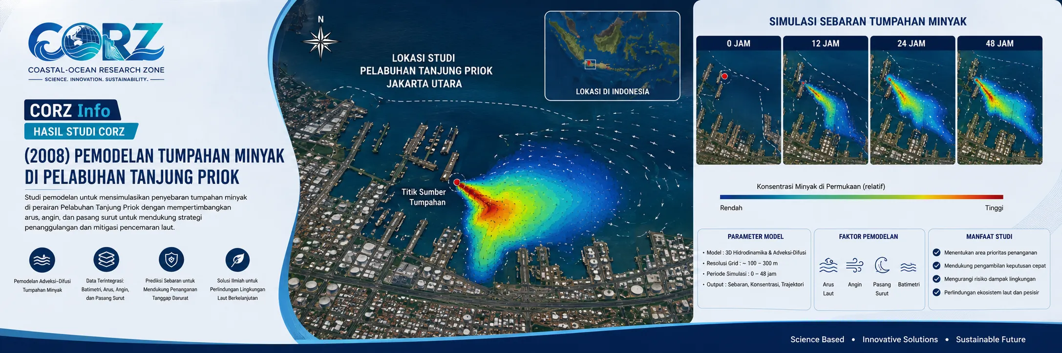
In 2008, CORZ Indonesia conducted Research & Studies involving numerical oil-spill distribution modelling at Tanjung Priok Port, combining two petroleum types with two major seasonal conditions.
The study comprised:
- Crude Oil — West Monsoon
• Crude Oil — East Monsoon
• Gasoline — West Monsoon
• Gasoline — East Monsoon
A single port environment was therefore investigated through four oil-spill scenarios, allowing the combined influence of oil type × monsoon conditions × marine hydrodynamics to be assessed.
2008: Tanjung Priok Under Growing Operational Pressure
The historical context of the study is significant.
On 8 February 2008, ANTARA reported plans to increase the capacity of Tanjung Priok Port by widening and deepening its navigation channel. The report described Tanjung Priok as Indonesia's largest port and highlighted the need for infrastructure improvement in response to growing business activity and demand.
ANTARA — Tanjung Priok Port Capacity to Be Increased, 8 February 2008
Later that year, ANTARA reported that container traffic entering the port had increased by approximately 13–14 percent, reaching around 160,000–185,000 containers per month.
ANTARA — Growing Cargo Traffic at Tanjung Priok, 11 September 2008
These reports were not reports about the CORZ study.
They nevertheless provide important historical context: increasing port and vessel activity also increases the importance of understanding and managing marine environmental risks.
CORZ Research: Connecting Oil Behaviour with a Moving Ocean
Oil released into water does not follow a fixed route.
Its movement is controlled by the interaction between the surrounding marine environment and the characteristics of the petroleum product itself.
Conceptually:
OIL RELEASE
↓
HYDRODYNAMIC CIRCULATION
↓
ADVECTION & DISPERSION
↓
OIL SPREADING
↓
SPILL TRAJECTORY
↓
POTENTIAL EXPOSURE
Numerical modelling enables these processes to be examined across space and time.
The spill source therefore becomes not the endpoint of the analysis, but the starting point of the oil's journey through the marine system.
Crude Oil: Modelling the Movement of Raw Petroleum
The first group of simulations focused on crude oil:
01 — Crude Oil | West Monsoon
02 — Crude Oil | East Monsoon
Crude oil has physical properties that influence spreading, mixing, weathering, and its interaction with the marine environment.
The modelling provides a framework for examining how crude oil released from a given source could interact with circulation within and around the port and develop an evolving spatial distribution.
The output therefore extends beyond simply showing where the spill begins.
It provides insight into the potential trajectory and spatial distribution of oil as the simulation progresses.
Gasoline: Different Petroleum, Different Behaviour
The second group of scenarios represented gasoline:
03 — Gasoline | West Monsoon
04 — Gasoline | East Monsoon
Gasoline differs significantly from crude oil and is generally lighter and more volatile. It would therefore be inappropriate to assume that all petroleum spills behave identically.
The principle is straightforward:
DIFFERENT OIL
= DIFFERENT PROPERTIES
= POTENTIALLY DIFFERENT SPILL BEHAVIOUR
By representing crude oil and gasoline independently, the CORZ study incorporates petroleum type as a fundamental component of oil-spill assessment.
West Monsoon vs East Monsoon
Oil type is not the only variable.
The ocean changes too.
Indonesia's monsoonal climate produces seasonal changes in winds and hydrodynamic circulation.
CORZ therefore evaluated every petroleum type under two seasonal conditions.
The underlying concept is:
**SAME LOCATION
- SAME OIL
- DIFFERENT MONSOON
= POTENTIALLY DIFFERENT SPILL TRAJECTORY**
A spill originating from the same point may not move toward the same area when environmental conditions change.
This seasonal comparison represents one of the strongest features of the study.
Four Scenarios, Two Fundamental Variables
The modelling programme can be summarised as:
CRUDE OIL
01 — West Monsoon
02 — East Monsoon
GASOLINE
03 — West Monsoon
04 — East Monsoon
The analysis therefore examines:
OIL TYPE × MONSOON CONDITION
This framework allows simulations to be compared to understand how variations in petroleum properties and seasonal hydrodynamics can influence spill behaviour.
For a major international port, preparedness should not depend on only one petroleum type and one oceanographic scenario.
Real Events Demonstrate Why Oil-Spill Modelling Matters
Oil pollution at Tanjung Priok is not merely hypothetical.
On 15 March 2016, Indonesian media reported oil contamination in the waters of Tanjung Priok Port, with petroleum residues reaching the coastal area. Pelindo II and port authorities stated that the pollution was not caused by a leaking fuel pipeline but was suspected to have originated from used fuel discharged by vessels. An Oil Spill Combat Team was deployed to prevent the contamination from spreading further.
Republika — Oil Spill Reaches the Tanjung Priok Coastal Area, 15 March 2016
Okezone — Oil Pollution Reported at Tanjung Priok Port
The 2016 incident was not an event predicted by the 2008 CORZ study.
Its relevance lies elsewhere: it demonstrates why understanding possible oil-transport pathways is important in a port environment with intensive vessel operations.
From Modelling to Preparedness
The issue remains relevant today.
In October 2025, Pelindo Regional 2 Tanjung Priok conducted a dedicated marine oil-spill response exercise at the port. The scenario included emergency notification, inter-agency coordination, deployment of a 315-metre oil boom, use of a skimmer, and temporary storage of recovered oil.
ANTARA — Pelindo Conducts Marine Oil-Spill Response Exercise at Tanjung Priok, 30 October 2025
In May 2026, the Tanjung Priok Port Authority and Pelindo again carried out an integrated crisis-management simulation in which oil-spill response was one of the principal emergency scenarios. The exercise involved energy terminals, container terminals, vehicle terminals, and other port facilities.
detikFinance — Oil-Spill Emergency Response Simulation at Tanjung Priok, 13 May 2026
Nearly two decades after the 2008 CORZ study, oil-spill preparedness remains a practical component of Tanjung Priok Port management.
Why Model the Spill Before Deploying the Oil Boom?
During a real emergency, equipment such as oil booms, skimmers, response vessels, temporary storage units, and trained personnel becomes critical.
But an essential question comes first:
Where is the oil likely to go?
Numerical modelling can help support assessment of:
- potential spill pathways;
- changes in trajectory over time;
- seasonal variations in transport direction;
- differences among petroleum products;
- marine areas that may require priority monitoring or protection; and
- scenarios required for an effective Oil Spill Contingency Plan.
The principle becomes:
MODELLING + RESPONSE CAPABILITY = BETTER PREPAREDNESS
From Simulation to Decision Support
For CORZ Indonesia, an oil-spill animation is not the final objective.
An animation visualises the process.
The real objective is usable information.
The workflow can be represented as:
ENVIRONMENTAL & OCEAN DATA
↓
HYDRODYNAMIC MODEL
↓
OIL CHARACTERISTICS
↓
SPILL SCENARIO
↓
TRAJECTORY & DISPERSION
↓
POTENTIAL EXPOSURE
↓
DECISION SUPPORT
Such modelling can support:
Oil Spill Contingency Planning • Port Environmental Management • Emergency Response Planning • Environmental Impact Assessment • Marine Terminal Risk Assessment • Sensitive-Area Protection • Marine Pollution Studies
Model the Spill Before It Reaches What Matters.
At a major port, activity never truly stops.
Ships arrive and depart.
Currents continue to move.
Monsoons change.
And different petroleum products can respond differently to the same marine environment.
The 2008 Tanjung Priok study reflects the CORZ Indonesia Research & Studies approach:
Know the Oil.
Understand the Current.
Compare the Seasons.
Model the Trajectory.
Prepare the Response.
Protect What Matters.
CORZ Indonesia for Research & Studies
Oil Spill Modelling • Hydrodynamic Modelling • Port Environmental Studies • Marine Pollution • Advection–Dispersion • Environmental Risk Assessment
Coastal-Ocean Research Zone (CORZ) Indonesia provides research, modelling, analysis, and technical solutions for coastal and ocean environments.
YouTube: https://www.youtube.com/@CORZIndonesia
Website: https://corz.co.id
Email: info@corz.co.id
© 2026 CORZ Indonesia. All Rights Reserved.


