
CORZ Indonesia | Research & Studies
Understanding the Current Before Infrastructure Is Placed on the Seabed
Check out some other model outputs on YouTube @CORZIndonesia
The sea may appear calm at the surface, yet beneath it water masses are continuously moving, transferring energy through current systems that vary across both space and time.
When a subsea pipeline is planned across the seabed, understanding that moving environment becomes an important part of the engineering assessment.
A pipeline is not installed in a static environment. It operates within a marine system influenced by currents, tides, seabed conditions, sediment dynamics, and other oceanographic processes.
The question is therefore not simply:
“Where should the pipeline be installed?”
More meaningful questions include:
How do currents circulate along the proposed corridor?
What are the dominant flow directions?
How does current velocity vary spatially and temporally?
And how can hydrodynamic information support safer and more effective subsea-pipeline planning?
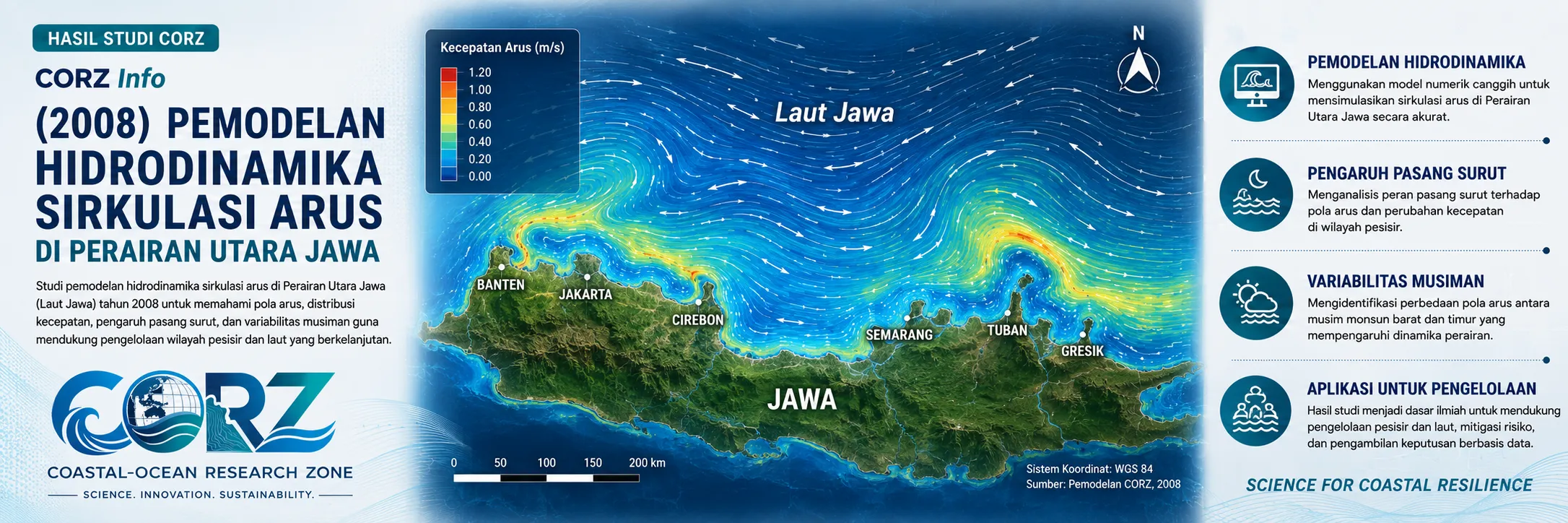
In 2008, CORZ Indonesia's Research & Studies activities included hydrodynamic current-circulation modelling in the waters north of Java to support a seabed pipeline installation study.
The study applied numerical modelling to transform marine dynamics into spatial and temporal information on current circulation, enabling the physical characteristics of the study area to be understood as an interconnected marine system.
Northern Java: A Strategic Offshore Energy Corridor
The waters north of Java have long been important to Indonesia's offshore energy infrastructure.
The historical context of 2008 is particularly relevant. detikFinance reported that PLN was preparing additional gas supplies for the Tambak Lorok power station in Semarang that year. By the end of 2008, PLN and Petronas Carigali had reached an agreement related to gas supply from the Kepodang Field; subsequent development involved plans for a subsea pipeline connecting an offshore gas field north of the Muria Peninsula with Tambak Lorok.
detikFinance — Gas infrastructure development and Tambak Lorok plans in 2008
detikFinance — Kepodang–Tambak Lorok and the offshore-pipeline development context
These reports were not reports about the CORZ study and should not be interpreted as linking the CORZ modelling directly to those projects.
They do, however, provide relevant historical context: during the same period, subsea energy infrastructure in the northern Java marine environment was becoming increasingly important.
This is precisely where ocean science meets engineering.
Before infrastructure is placed on the seabed, the ocean itself must be understood.
CORZ Research: Modelling the Physical Engine of the Ocean
The CORZ study focused on hydrodynamic current circulation as a fundamental component of the marine environment in which subsea infrastructure is installed.
Conceptually, the workflow can be expressed as:
OCEANOGRAPHIC DATA → HYDRODYNAMIC MODEL → CURRENT CIRCULATION → SPATIAL & TEMPORAL ANALYSIS → SUBSEA PIPELINE STUDY
A hydrodynamic model represents how water masses move throughout the study domain.
Simulation results allow current patterns to be analysed in terms of direction, velocity distribution, temporal variability, and spatial differences across the study area.
This is where numerical modelling provides significant added value.
Field measurements describe conditions at particular places and times; numerical modelling helps connect those observations into a broader representation of the marine system.
From Current Vectors to Engineering Information
One of the most recognisable outputs of a hydrodynamic model is the current vector.
Those arrows are more than graphical elements.
Each carries information about:
direction + velocity + location + time
Combined, they provide an evolving picture of how the marine environment behaves along the area being investigated.
For subsea-pipeline studies, such hydrodynamic information is technically relevant to route evaluation, installation planning, assessments of the surrounding seabed environment, and subsequent analyses related to pipeline stability, sediment interaction, or scour.
In other words:
the current does not simply flow past the pipeline—it forms part of the pipeline's environmental design conditions.
A Subsea Pipeline Does Not Exist in Isolation
A subsea pipeline begins interacting with its marine environment from the moment it is installed and continues to do so throughout its operating life.
Water flowing around the structure may be associated with hydrodynamic loading and interactions among the pipeline, sediment, and seabed.
Current modelling can therefore provide an important input to more specialised engineering assessments such as route assessment, pipeline stability, seabed interaction, scour analysis, burial consideration, and installation planning.
Hydrodynamic modelling does not replace geophysical surveys, geotechnical investigations, structural engineering, or pipeline-integrity analysis.
Its role is complementary and powerful:
it connects engineering design with the dynamic marine environment in which that design must operate.
The integrated system can be viewed as:
SEABED + PIPELINE + CURRENT + SEDIMENT + ENGINEERING
Relevance That Continues Nearly Two Decades Later
The need for subsea-pipeline infrastructure in northern Java has continued well beyond 2008.
In June 2025, PHE Offshore North West Java completed construction and renewal of three subsea oil-and-gas pipeline sections totalling 22.06 kilometres in the northern Java Sea. The pipelines connect offshore platforms and support approximately 2,691 barrels of oil production per day.
detikFinance — 22-km subsea pipeline project completed in the Java Sea, June 2025
Later that month, detikFinance also reported development of the OOA offshore platform in northern West Java. The facility was planned to connect to the Balongan Onshore Processing Facility through a 12-inch subsea pipeline approximately 14 km long.
detikFinance — New offshore platform and 14-km subsea pipeline to Balongan
These modern projects are not directly connected to the 2008 CORZ study.
Their significance is that they demonstrate the continuing importance of subsea infrastructure engineering in the waters north of Java.
Technology evolves.
Infrastructure changes.
Yet one fundamental requirement remains:
understand the ocean before engineering within it.
From Simulation to Engineering Decision Support
The value of a hydrodynamic model does not end when the numerical simulation is completed.
Its value begins when the simulation can answer practical engineering questions.
For CORZ Indonesia, the transformation is:
DATA
↓
HYDRODYNAMICS
↓
CURRENT CIRCULATION
↓
ENVIRONMENTAL UNDERSTANDING
↓
ENGINEERING INFORMATION
↓
BETTER DECISIONS
The same approach can support studies involving subsea pipelines, offshore structures, submarine cables, marine outfalls, seawater intakes, ports, reclamation, dredging, and other coastal and offshore infrastructure.
Understand the Current Before Laying the Line.
A subsea pipeline may extend for tens or even hundreds of kilometres.
Yet along every kilometre, it remains within the same fundamental system:
a moving ocean.
The 2008 Northern Java study reflects a core principle of CORZ Indonesia's Research & Studies:
Map the Current.
Understand the Seabed Environment.
Support the Route.
Reduce Uncertainty.
Engineer with the Ocean—not against it.
CORZ Indonesia for Research & Studies
Hydrodynamic Modelling • Current Circulation • Subsea Pipeline Studies • Offshore Engineering Support • Sediment & Seabed Studies • Coastal & Ocean Modelling
Coastal-Ocean Research Zone (CORZ) Indonesia provides research, modelling, analysis, and technical solutions for coastal and ocean environments.
YouTube: @CORZIndonesia
Website: corz.co.id
Email: info@corz.co.id
© 2026 CORZ Indonesia. All Rights Reserved.


