
CORZ Indonesia | Research & Studies
Understanding Where Crude Oil Could Travel in a Changing Ocean
Check out some other model outputs on YouTube @CORZIndonesia
Natuna is far more than a group of islands on Indonesia's northern frontier.
Its surrounding waters form a strategically important marine region where offshore oil and gas resources, international shipping, fisheries, and marine ecosystems coexist within a highly dynamic ocean environment.
In such a region, understanding oil-spill risk requires more than identifying where an accidental release may occur.
The critical questions are:
Where will the oil travel once it enters the sea?
How far could the spill spread?
Which marine areas could potentially be exposed?
And would the trajectory remain the same when the monsoon changes?
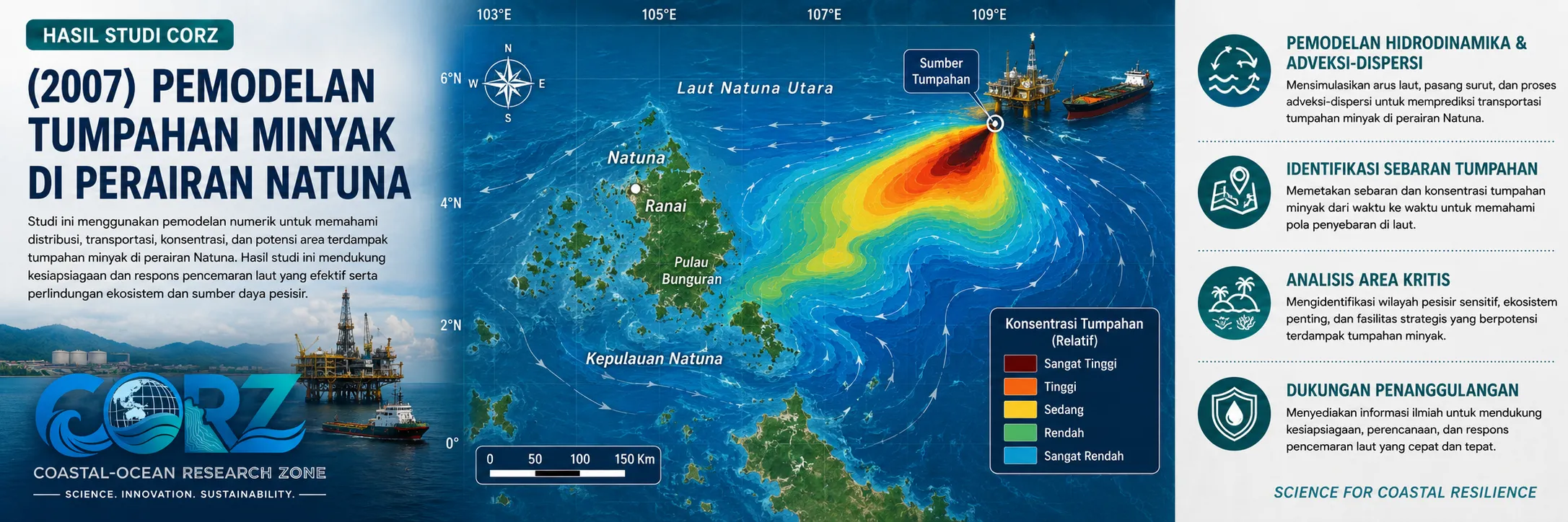
In 2007, CORZ Indonesia conducted Research & Studies involving numerical crude-oil spill modelling in Natuna waters, representing Indonesia's two principal monsoon conditions:
- Crude Oil Spill Distribution Modelling — West Monsoon
- Crude Oil Spill Distribution Modelling — East Monsoon
The two scenarios were used to investigate how seasonal changes in hydrodynamic conditions could produce different transport pathways and spill-distribution patterns from the same potential source.
Natuna in 2007: An Increasingly Strategic Energy Region
The timing of the study provides important historical context.
On 26 March 2007, ANTARA reported that the Indonesian government had asked Pertamina to form a consortium for the development of the Natuna D-Alpha Block, a major offshore gas resource requiring substantial technology and investment.
ANTARA — Indonesian Government Calls for Consortium to Develop Natuna, March 2007
In April 2007, ANTARA again reported government deliberations over the future management of the Natuna D-Alpha Block, demonstrating the strategic importance of offshore energy development in the region during the same period.
These reports were not reports about the CORZ study. They provide historical context showing why understanding marine processes around Natuna was increasingly important as offshore energy activities developed.
Energy development requires technology.
Managing its environmental risks requires science as well.
CORZ Research: From Hydrodynamics to Oil-Spill Trajectory
Oil released into the sea does not determine its own path.
Its movement interacts with the surrounding oceanographic system. Currents transport the oil away from its source, surface conditions influence its movement, and spreading and weathering continue as the spill evolves.
Hydrodynamics therefore acts as the physical engine driving pollutant transport.
Conceptually:
CRUDE-OIL RELEASE
↓
HYDRODYNAMIC CIRCULATION
↓
TRANSPORT & DISPERSION
↓
SPILL TRAJECTORY
↓
SPATIAL DISTRIBUTION
↓
POTENTIAL EXPOSURE
The CORZ modelling approach enables this process to be investigated through both space and time, transforming an oil spill from a static source point into an evolving marine-transport problem.
West Monsoon: One Ocean Condition, One Potential Pathway
The West Monsoon scenario examined how seasonal circulation conditions could control crude-oil transport.
The simulation provides a framework for assessing the potential direction of oil movement, spatial development of the spill, connections between the source and receiving waters, and marine areas lying along potential transport pathways.
The modelling question therefore moves beyond:
“Where did the spill begin?”
toward:
“Where might it go next?”
For oil-spill response, that distinction is fundamental.
East Monsoon: Same Source, Different Marine Response
CORZ then modelled the equivalent scenario under East Monsoon conditions.
This comparison is central to the study.
Indonesia's monsoonal climate creates seasonal changes in winds and marine circulation. Consequently:
**SAME OIL
- SAME SOURCE
- DIFFERENT MONSOON
= POTENTIALLY DIFFERENT TRAJECTORY**
An area that may lie outside the principal spill pathway during one season may experience a different level of potential exposure under another.
This is why multi-season scenario modelling can provide much stronger support for oil-spill preparedness than a single static scenario.
Two Models, One Strategic Question
The Natuna study consisted of:
01 — Crude Oil Spill Distribution | West Monsoon
02 — Crude Oil Spill Distribution | East Monsoon
The comparison isolates one particularly important factor:
SEASONAL HYDRODYNAMIC VARIABILITY
The assessment therefore evolves from the basic question:
“What happens if oil is released?”
to the more strategic question:
“How could the potential consequences change if the same spill occurred under a different monsoon regime?”
Oil-Pollution Risk in Natuna Is Not Merely Theoretical
The continuing relevance of this research became increasingly clear over the following years.
In 2021, ANTARA reported government acknowledgement that Indonesia still needed to improve efforts to prevent oil-spill incidents. The report specifically identified the Natuna Sea as an area with significant pollution potential because of intensive maritime traffic and the possibility of vessel-related pollution, including oil spills.
ANTARA — Indonesian Government Highlights Continuing Oil-Spill Risks
The issue became particularly tangible in July 2023, when Indonesian authorities seized the Iranian-flagged supertanker MT Arman 114 in the North Natuna Sea.
The vessel was carrying approximately 272,569 metric tons of light crude oil and was suspected of conducting an unauthorised ship-to-ship transfer. A Reuters report published by The Jakarta Post also stated that the vessel was suspected of dumping oil into the sea.
detikNews likewise reported the seizure and the vessel's substantial light-crude-oil cargo.
These events were not predicted by the 2007 CORZ modelling study.
Their significance is different: they demonstrate why the capability to simulate crude-oil transport remains relevant for protecting the Natuna marine environment.
Natuna Today: Offshore Energy Continues to Expand
Nearly two decades after the 2007 study, Natuna remains strategically important to Indonesia's energy sector.
On 16 May 2025, first production from the Forel and Terubuk offshore fields in Natuna was inaugurated. ANTARA reported expected combined production of approximately 20,000 barrels of oil per day and an additional 60 MMSCFD of gas.
ANTARA — First Production from Forel and Terubuk Fields in Natuna
This continuing development reinforces an important principle:
ENERGY DEVELOPMENT + ENVIRONMENTAL PREPAREDNESS
The more strategically important an offshore region becomes, the more important its capacity to anticipate and manage marine environmental risks.
From Simulation to Oil-Spill Decision Support
At CORZ Indonesia, oil-spill modelling is not simply about generating an animation of an oil slick moving across a map.
Its greater value lies in the decision-support information derived from the simulation.
A modelling framework such as the Natuna study can contribute to:
Oil Spill Contingency Planning • Emergency Response • Offshore Oil & Gas Studies • Environmental Impact Assessment • Pipeline & Platform Risk Assessment • Sensitive-Area Protection • Marine Environmental Management
During a real emergency, response time is critical.
Numerical modelling can help address questions such as:
Where could the oil travel?
Which areas may require early monitoring or protection?
Could seasonal conditions change the areas at risk?
How should response scenarios adapt to changing ocean conditions?
The transformation is:
DATA → MODEL → TRAJECTORY → EXPOSURE INFORMATION → DECISION SUPPORT
Model the Spill Before the Ocean Decides Where It Goes.
The 2007 Natuna study illustrates a simple but important principle:
The ocean determines the pathway of marine pollutants through its physical dynamics.
And those dynamics change with the seasons.
Oil-spill preparedness therefore begins with understanding the ocean before an emergency occurs.
Understand the Water.
Model the Spill.
Compare the Seasons.
Anticipate the Pathway.
Protect the Marine Environment.
CORZ Indonesia for Research & Studies
Oil Spill Modelling • Hydrodynamic Modelling • Offshore Environmental Studies • Marine Pollution • Advection–Dispersion • Environmental Risk Assessment
Coastal-Ocean Research Zone (CORZ) Indonesia provides research, modelling, analysis, and technical solutions for coastal and ocean environments.
YouTube — CORZ Indonesia
Website — CORZ Indonesia
Email: info@corz.co.id
© 2026 CORZ Indonesia. All Rights Reserved.


