
CORZ Indonesia | Research & Studies
Understanding Water Dynamics to Support Port Development
Check out some other model outputs on YouTube @CORZIndonesia
Developing a port is about much more than constructing terminals, berths, and landside infrastructure. Beneath the water surface lies a continuously evolving system of currents, tides, and sediments that can strongly influence how a port environment develops and performs over time.
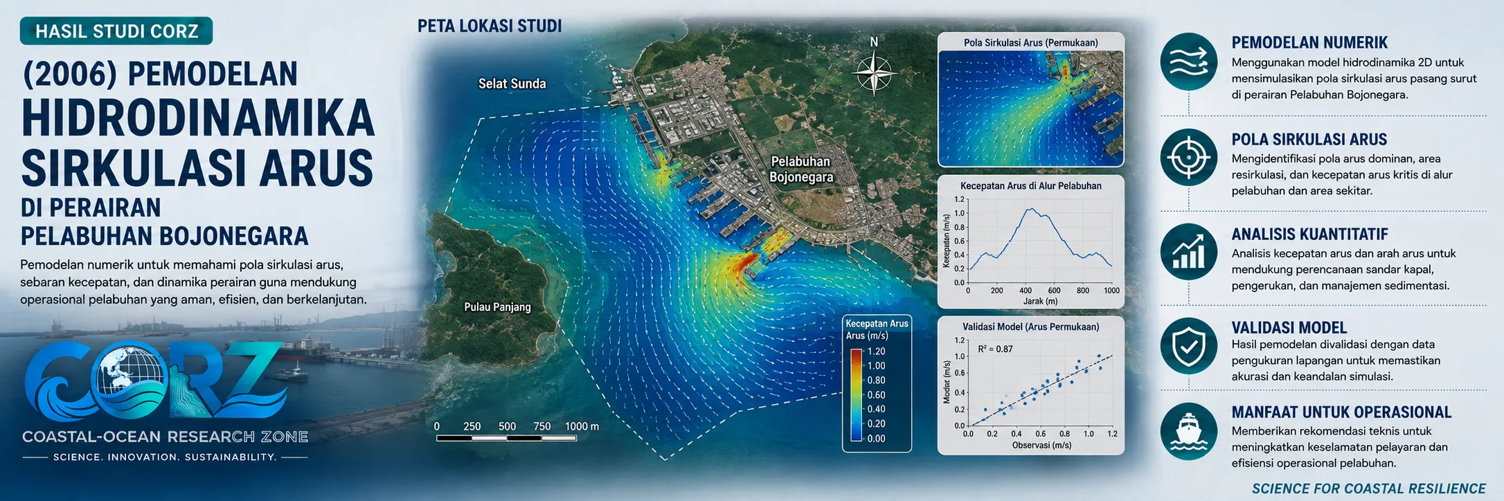
In 2006, CORZ Indonesia's Research & Studies activities included hydrodynamic and mud-transport modelling in the waters of Bojonegara, Banten, as part of a technical study supporting the development of Bojonegara Port.
The study placed numerical modelling at the centre of an important principle: understanding the physical behaviour of coastal waters before making decisions about major coastal and port infrastructure.
When Bojonegara Was Envisioned as a Strategic Port
The year 2006 represented an important period in the development plans for Bojonegara Port.
On 11 February 2006, Indonesian Vice President Jusuf Kalla, accompanied by several cabinet ministers, visited the Bojonegara Port development site. ANTARA reported at the time that the first phase of port development involved an investment of approximately IDR 170 billion. ANTARA — Indonesian Vice President visits Bojonegara Port development, 11 February 2006
On the same day, ANTARA reported the government's confidence that Bojonegara could be developed into an international port, provided that its development was integrated with sufficient land and an industrial hinterland. ANTARA — Vice President confident Bojonegara Port can be developed
The project was also covered by other major Indonesian media. detikNews reported calls for Bojonegara to become part of an integrated industrial area, while Liputan6 reported its potential development as an international port. detikNews — Bojonegara Port and integrated industrial development Liputan6 — Development plans for Bojonegara Port
Within this development momentum, understanding the physical characteristics of the surrounding marine environment became particularly important.
CORZ Research: From Current Circulation to Mud Transport
CORZ Indonesia conducted hydrodynamic modelling to investigate current circulation in Bojonegara Port waters, together with mud-transport modelling to examine the potential movement of fine sediments within the area.
Hydrodynamic modelling provides a numerical representation of how water masses circulate through the marine environment.
The simulations can be used to investigate:
- current circulation patterns and directions;
- spatial and temporal variations in current velocity;
- hydrodynamic behaviour around the port environment; and
- relationships between current circulation and sediment movement.
The study was extended through mud-transport modelling to investigate the dynamic behaviour of fine sediment.
Sediment in a port environment is not static.
Material may be eroded from one location, transported by currents through the water column, and subsequently deposited elsewhere.
Understanding this interaction between hydrodynamics and sediment transport is therefore an important element of port and coastal-engineering studies.
Connecting Hydrodynamics and Sedimentation
An important aspect of the CORZ approach is that hydrodynamics and sedimentation are not treated as completely separate processes.
Currents move sediment.
Sediment responds to current dynamics.
Together, they influence the evolving condition of port waters.
By integrating hydrodynamic and mud-transport modelling, the study provides a framework for understanding water circulation together with potential sediment-transport and deposition patterns.
Such information can provide a technical foundation for evaluating different aspects of port planning and management, including conditions surrounding port infrastructure, sedimentation tendencies, navigational-water assessments, and future coastal-infrastructure development.
Turning Numerical Models into Decision-Support Information
At CORZ Indonesia, the value of numerical modelling extends beyond producing maps, current-vector plots, concentration distributions, or animations.
Its greater value lies in the information extracted from those simulations.
Numerical modelling enables marine processes to be examined across both space and time, providing a way to investigate processes that would be difficult to observe comprehensively through field measurements alone.
The modelling workflow helps transform:
data → simulation → process understanding → technical information → decision support.
This represents one of CORZ Indonesia's fundamental approaches to coastal and ocean studies: combining physical-process understanding with numerical modelling technology to address real-world coastal challenges.
Nearly Two Decades Later, Bojonegara Remains Strategically Relevant
The significance of Bojonegara did not end with the development plans of 2006.
In March 2025, Pelindo prepared Bojonegara Port as a supporting facility to help relieve potential congestion in the Merak ferry-port system. ANTARA — Pelindo prepares Bojonegara Port to support Merak operations
In July 2025, the Governor of Banten proposed developing Bojonegara into a national export port, highlighting its location and naturally favourable water depth as assets for large-scale port development. ANTARA — Bojonegara proposed as a national export port
These developments demonstrate the continuing strategic importance of Bojonegara and reinforce the relevance of understanding the hydrodynamic and sedimentary characteristics of its surrounding waters.
Research Today. Better Coastal Decisions Tomorrow.
The Bojonegara study represents part of CORZ Indonesia's continuing journey in applying ocean modelling at the intersection of science, engineering, and coastal development.
From current circulation to sediment transport, every simulation serves a common purpose:
to understand how the marine environment works before we build and make decisions within it.
Understand the Water.
Model the Process.
Support Better Decisions.
CORZ Indonesia for Research & Studies
Hydrodynamic Modelling • Sediment Transport • Coastal Engineering • Port Studies • Ocean Analysis
Coastal-Ocean Research Zone (CORZ) Indonesia provides research, modelling, analysis, and technical solutions for coastal and ocean environments.
YouTube: https://www.youtube.com/@CORZIndonesia
Website: https://corz.co.id
Email: info@corz.co.id
© 2026 CORZ Indonesia. All Rights Reserved.


